Alberta government seeking feedback on new Edmonton-area flood maps
The Alberta government is seeking public input on the new flood maps for the North Saskatchewan River in the Edmonton area.
The flood study's authors want members of the public to review the maps — accessible now in draft form — and review the reports that go with them.
"We'd like to get any technical comments that they have about it," said Jim Choles, a river engineer with Environment and Protected Areas Alberta and the project lead for the study.
"There may be errors, or something that needs to be addressed," Choles said. "Public engagement is an integral part of our flood studies."
The draft flood maps are an update to existing flood mapping.
Studies that produced the previous flood maps were done in 1994 and 1995, Choles said, and they were extended to Fort Saskatchewan and Devon in 2007.
Those maps are being replaced with the new ones.
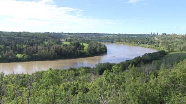
The North Saskatchewan flows from the Columbia Icefield in the Rockies across Alberta and Saskatchewan to Lake Winnipeg, and into the Nelson River before discharging into Hudson Bay.
Part of the purpose of public engagement, Choles said, is raising people's awareness of "flood risks in their community, and perhaps where they live."
This round of public engagement is one of the final steps in the process of the flood maps' design, Choles said.
"Once we've looked at the comments and made decisions on how to handle them, then we will either make corrections, or proceed and finalize the studies."
The new flood maps extend from Range Road 265, west of Devon, downstream to the Vinca Bridge, northeast of Fort Saskatchewan.
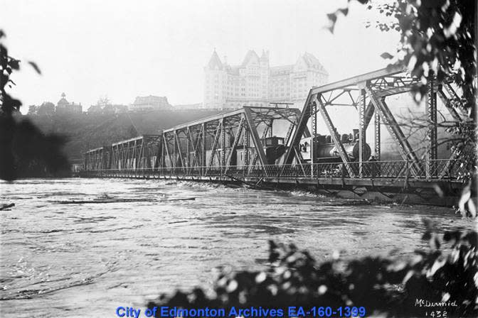
Fast-moving water threatened to destroy the Low Level Bridge in 1915. Train cars loaded down with sand were backed onto the bridge deck to prevent it from washing away. (City of Edmonton Archives)
Green infrastructure helpful for flood mitigation
Choles said the Edmonton area is not especially vulnerable to flooding. The North Saskatchewan River valley is fairly deep and narrow compared to other areas, and there isn't a great deal of development in the valley.
"We do have some, but a lot of it is forested, and so we don't find that there's a lot of areas that can be flooded," Choles said.
Scott Millar, the executive director at North Saskatchewan Watershed Alliance, concurs.
"In terms of the flooding that happens in the mainstem river, I think Edmonton is in an excellent position at this point, because the integrity of the watershed upstream from Edmonton is, actually, in pretty good shape," he said.
"The watershed upstream from Edmonton is able to handle an awful lot of water. And in addition, there's two dams on the river that do help mitigate some of the flows as well," he said. The dams are the Bighorn, in Clearwater County, and the Brazeau, southwest of Drayton Valley.
"In terms of the city itself, of course, the city has a lot of hard roads, and parking lots, and things like that," Millar said.
All these surfaces shed water that has to go somewhere, he said. "It has to be handled by pipes. It has to be handled by drainage."
He said the city and Epcor are working hard to build more green infrastructure, "so that those kinds of overland or surface flooding events are less likely, or impacts are less severe."
Natural systems, such as shoreline vegetation and wetlands, also play a big role in flood mitigation, Millar said. They are able to absorb water and slow down its flow before it enters the river.
For the hazard maps — the ones being used for flood planing and are offered to the public for feedback — the authors included three types of flood 1:100, 1:200 and 1:500.
They focused on the 1:100 flood, which has a one per cent chance of occurring each year. The maps also include larger floods, described as 1:200 and 1:500.
The North Saskatchewan River flood study, which covers Edmonton and adjacent areas, is one of 27 new flood studies being conducted in the province that are at the public engagement stage.
Public engagement for North Saskatchewan River flood study is open until Feb. 12.
People can provide feedback by completing this survey.

