Allen Coral Atlas adds spectacular satellite views of Australia’s Great Barrier Reef
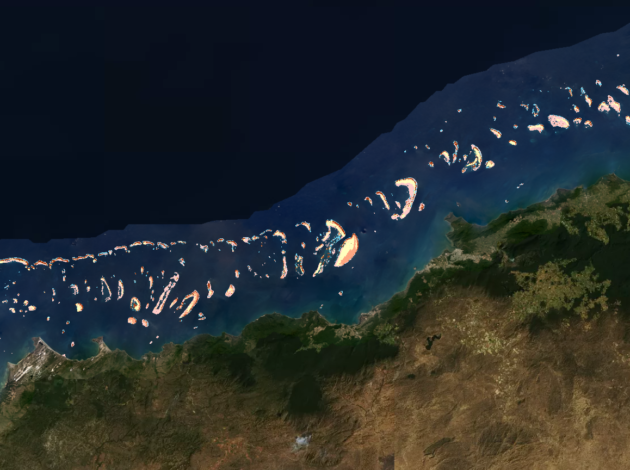
When you think of the crown jewels of the coral reefs, it’s hard not to think of Australia’s Great Barrier Reef — and now those jewels are on full display in the Allen Coral Atlas, one of the scientific legacies left behind by Microsoft co-founder Paul Allen.
The atlas was unveiled just a couple of weeks after Allen’s death last October, following through on one of the late billionaire’s passions: preserving the world’s oceans. This month’s addition of satellite-based imagery covering 3,000 square kilometers of the central Great Barrier Reef, from Cairns to Cooktown, represents the largest expansion of the atlas to date.
The project drew upon expertise from the University of Queensland’s Remote Sensing Research Center in Australia, working in league with National Geographic and the Allen Coral Atlas project’s other partners. Satellite images from the Planet Dove constellation were processed by Arizona State University’s Center for Global Discovery and Conservation Science to produce data about bottom reflectance and depth.
That additional processing makes the Allen Coral Atlas much more than an album of pretty pictures. In the online database, you can click the buttons on the imagery to get a sense of the coral reef’s geomorphic makeup, and gain insights into the coral reef’s benthic habitat thanks to color-coded data overlays.
“This is the first demonstration of our regional scaling model – a methodology that allows our team to quickly map multiple, related reefs using a common set of algorithms,” Lauren Kickham, senior director for the Allen Coral Atlas project at Paul Allen’s Vulcan Inc., said in an emailed statement. “This will accelerate expansion of the atlas to global coverage within two years, giving coral scientists critical information they need to protect and restore the world’s reefs.”

Like the Great Barrier Reef, the atlas is designed to change over time, reflecting how the corals cope with environmental threats from warming oceans and bleaching events, tropical cyclones, pollution and outbreaks of crown-of-thorns starfish.
This month, a U.N. report warned that nearly 33 percent of reef-forming corals are threatened with extinction, and Vulcan Inc. intends for the Allen Coral Atlas to furnish the data needed to track the threat and identify strategies for preserving and restoring the reefs.
Thanks to the latest addition, 237 reefs are now viewable online. The next regional map is scheduled for release this summer — and as Vulcan’s Kickham said, the plan is to have all of the world’s coral reefs covered by the end of next year.
Zero in on the Great Barrier Reef with the Allen Coral Atlas’ online image viewer.
More from GeekWire:
Allen Coral Atlas tracks changes in the world’s reefs from space via satellite
Paul Allen enlists machine-learning tools for monitoring wildlife and ecosystems
Paul Allen team locates another long lost warship as USS Lexington is found 76 years after sinking
Sources: Paul Allen’s family foundation plans to add advisers, with Steve Ballmer among prospects
