Almost 'time to go to work': What to know about wildfire outlook in Larimer County, state
GLEN HAVEN — Chain saws whine and hoes clank as members of the Larimer County Initial Attack Module remove junipers and shrubs and dig fire breaks to create a "catcher’s mitt" just outside Glen Haven, where a ridge over the 2020 Cameron Peak Fire burned frighteningly close.
This is the grunt work to protect Colorado’s ever-growing wildland-urban interface, where homes intermingle with forests and grassland open spaces. In Colorado, the number of homes in this interface is forecast to increase from 300,000 statewide today to 720,000 by 2030.
Larimer County ranks among the top counties in the state threatened by wildfires in this interface.
"The wildland-urban interface is a big part of fires these days," says Brad Stricker, one of the module’s handful of firefighters working on the break. "Everybody wants to build in the mountains, which is great, it’s beautiful, but it poses challenges for us to protect these areas."
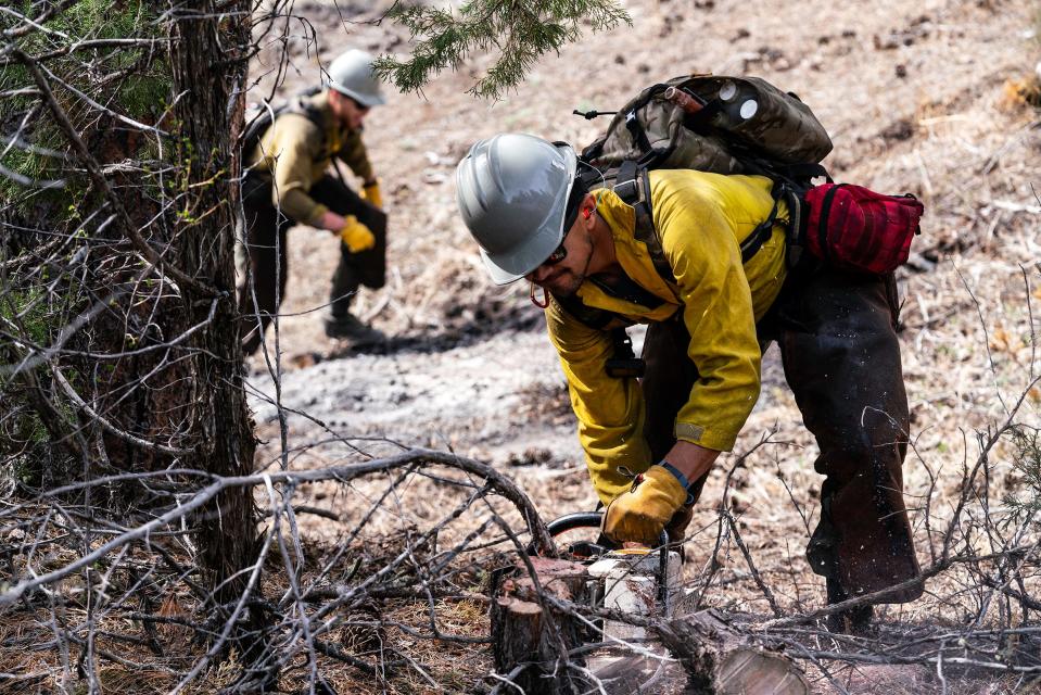
Tuesday’s backbreaking work serves a double purpose. It provides training for the firefighters and it creates defensible space — the catcher's mitt — in case a wildfire threatens the small enclave east of Estes Park.
"This training is important because this is becoming more and more of the firefighting we do," Stricker says.
While crews like this are on the ground, the state also has at its disposal an array of aircraft, including for the first time its own Firehawk helicopter designed to fight wildfires at high altitude and despite up to 70 mph wind.
"Right now, we’re sitting pretty good, but when you are here walking and things are crunching under your boots, definitely the hair on the back of our neck is up and you’re just kind of waiting," Sticker says with hoe in hand. "Floods will probably be more of a concern off the bat but, as we know, everything will dry out and then it’s time to go to work."
With that in mind, here's a look at wildfire history in Colorado and our outlook for this fire season.
Colorado wildfires are increasing, growing larger and threatening more lives. Here's why.
Fifteen of the state's 20 largest wildfires have occurred since 2012.
The three largest wildfires in Colorado history all occurred in 2020: Cameron Peak (208,913 acres), East Troublesome (193,812 acres) and Pine Gulch (139,007 acres).
In the 1990s, Colorado averaged 1,300 wildfires and 22,000 acres burned per year. From 2012 through 2022, Colorado had an average of 5,507 fires and 221,661 acres burned per year.
More than 3 million Coloradans live in the wildfire-prone wildland-urban interface (area where structures and other human development intermingles with wildland vegetation) with homes in this area projected to increase from 300,000 to 720,000 by 2030.
Main reasons for wildfire changes: Changing climate, namely it being drier and warmer in Colorado, and increased fuel loads due to years of fire suppression and such things as beetle kill.
Here's a visual representation of Colorado's largest fires by acreage, homes lost
Here's a visual representation of the average number of fires, acres burned per year
What is the wildfire outlook for the season in Larimer County and Colorado overall?
Experts agree, at least through June, we are looking at moderate conditions in the state and locally. The outlook for the rest of the summer will be announced at a later date.
Becky Bolinger, assistant state climatologist: "Moderate seems pretty good for our area. There is always a risk unless you have snow on the ground. At this point, I don’t see wildfire conditions that could get out of control and really bad. Once we get into summer, things can change quickly if we get a string of hot, dry, windy days."
Colorado Department of Fire Protection: "While it is too early to forecast with accuracy what the 2023 core fire season will bring for certain, significant wildland fire potential is expected to remain normal in many areas of Colorado during the late spring and into the summer. This outlook is heavily weighted upon persistent conditions, continued average to below average temperatures over most of Colorado, and normal precipitation through April."
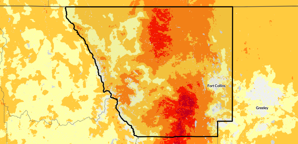
What areas in Larimer County are most vulnerable to wildfires?
There are multiple wildfire risk modeling maps that include this information. Here are some of the more respected sites, according to wildfire experts. Generally, Larimer County is ranked near or in the top five Colorado counties in homes at risk of wildfire in the state.
Colorado State Forest wildfire atlas: Generally, this site says higher risk areas include either side of Taft Hill Road from Fort Collins to Loveland, the area between Wellington and U.S. Highway 287 north, the area between the town of Drake and Masonville north to Buckhorn Canyon, and just west of Loveland, south to Berthoud.
U.S. Forest Service Wildfire Risk to Communities: This site has the county at higher wildfire risk than 76% of counties in the U.S., ranking the county high in risk to homes and wildfire likelihood and medium in homes exposed to wildfire and vulnerable populations. It points toward higher wildfire risk in the north-central part of the county from near Red Feather Lakes north to the Wyoming state line and the area between Fort Collins and Estes Park south to the county line.
First Street Foundation: The site rates the county at major risk of wildfire over the next 30 years. Generally, it concurs with the atlas with the area between Wellington and U.S. Highway 287 and extending into the lower Poudre Canyon and the area between Fort Collins and Loveland west to Estes Park as being at higher risk.
What is the wildfire risk to Larimer County towns and cities?
According to Wildfire Risk to Communities, here is a look at its wildfire assessment of municipalities in Larimer County:
Red Feather Lakes: Very high risk, higher than 96% of communities in the U.S.
Estes Park: Very high risk, higher than 92% of communities in the U.S.
Timnath: High risk, higher than 82% of communities in the U.S.
Loveland: Medium risk, higher than 70% of communities in the U.S.
Fort Collins: Medium risk, higher than 69% of communities in the U.S.
Windsor: Medium risk, higher than 66% of communities in the U.S.
Wellington: Medium risk, higher than 63% of communities in the U.S.
Severance: Medium risk, higher than 57% of communities in the U.S.
Projects in place for Larimer County wildfire mitigation
Black Diamond Landscape Resiliency and Risk Reduction Project: In 2022, the Canyon Lakes District of the Roosevelt National Forest began planning its ambitious project that would authorize various mitigation treatments to protect communities, wildlife, watersheds and other values at risk from high-severity wildfires. The project includes nearly 265,760 acres in northern Larimer County, including 71.5% forest service land and 28.5% local, state or private land. The project is hoping for a decision on the project in 2023.
Pierson Park Fuel Project: This forest service project is planned to start this summer south of Estes Park, primarily along Pierson Park Road, Johnny Park Road and several other U.S. Forest Service road segments in the U.S. Highway 36 corridor. Its aim is to reduce overgrown and hazardous forest conditions along forest service roads through mechanical thinning and prescribed burns, allowing firefighters to manage and contain fires.
Magic Feather Prescribed Burn project: Burning is scheduled to resume in spring as conditions allow. The treatment area is located east and southeast of Red Feather Lakes. Numerous previous prescribed burns have taken place in the Red Feather Lakes and Poudre Canyon area in recent years.
Slash pile burning: During the 2022-23 winter months, the Canyon Lakes Ranger District burned more than 16,000 slash piles across the district.
How to be alerted during a wildfire and prevention tips
NOCO Link: This is the latest tool Larimer Emergency Telephone Authority is using to link Larimer County emergency communication centers to livestream videos and photos from mobile callers with reception in real time. Visit leta911.org/nocolink to learn more.
LETA alerts: Visit nocoalert.org to sign up. Log into your account or create an account. Then go to "my subscriptions," select "event alerts" and then select the categories you would like alerts for and fill out the information. The system can send you alerts via cellphone, landline and email.
Text messages: For alerts on an array of emergency events throughout Larimer County, text NOCOAlert to 888777.
Social media accounts to follow:
LETA: On Twitter at @LETA_911 and on Facebook at www.facebook.com/LETA911.
National Weather Service (Boulder): On Twitter at @NWSBoulder and on Facebook at www.facebook.com/NWSBoulder.
Larimer County Sheriff's Office: On Twitter at @LarimerSheriff and on Facebook at https://www.facebook.com/larimersheriff.
Poudre Fire Authority: On Twitter at @PoudreFire and on Facebook at www.facebook.com/PoudreFire.
Homeowner wildfire mitigation tips
Colorado State Forest Service offers wildfire mitigation tips at https://csfs.colostate.edu/wildfire-mitigation/.
This article originally appeared on Fort Collins Coloradoan: What to know about wildfire risk in Larimer County, Colorado

