Arctic blast to send a chill through midwestern, eastern US


Cold air will dive down from Canada and greet much of the central and eastern United States by the end of the week.
Following a swath of snow pushing through the northern tier early in the week, colder air will move in behind the storm and even farther south into parts of the south.
While the temperatures expected during the middle of the week will not be as brutal as the last cold spell with temperatures some 5 to 20 degrees Fahrenheit higher, it will still be a drastic change.
A warmup will precede the cold plunge.
"Before a storm moves through the eastern half of the country, places from Chicago to Philadelphia will experience temperatures that are on the order of 5-10 degrees above normal for mid-February," said AccuWeather Meteorologist Max Gawryla.
 |
This image shows actual temperatures as of 1 p.m. EST Monday, Feb. 17, 2020. (AccuWeather) |
On Monday, temperatures climbed into the 40s around Chicago, while Philadelphia can reach the 50s for the second day in a row on Tuesday.
Once the colder air sweeps in, the springlike temperatures will be erased and replaced with conditions more similar to January.
 |
"The Arctic air mass will send temperatures tumbling on Tuesday night across the Midwest, with lows in the single digits," added Gawryla.
Temperatures will be well below zero across parts of northern Illinois, Iowa, Wisconsin and Minnesota by Wednesday night.
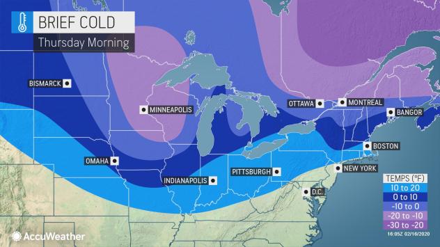 |
By Thursday morning, temperatures will be as low as 10 to 20 degrees below zero across parts of Minnesota and Wisconsin.
Without much wind to accompany the cold, AccuWeather RealFeel® temperatures will not be too far below the actual mercury reading. During the day, when the sun is shining, RealFeel® temperatures may actually be a little higher than the actual air temperature.
CLICK HERE FOR THE FREE ACCUWEATHER APP
The lowest temperatures are expected in the Northeast by Friday morning. Temperatures are expected to dip into the single digits and teens across interior parts of the Northeast.
Lows are forecast to be from 13 degrees in Pittsburgh to 10 degrees in Syracuse, New York, Friday morning. In perspective, the blast from this past weekend brought morning low temperatures of 8 above zero and 5 below zero in the two cities respectively.
"Even though this Arctic outbreak will not be as intense as late last week, it will last a little while longer," according to AccuWeather Senior Meteorologist Alex Sosnowski.
"The blast from late last week was generally limited to 24-36 hours. The cold outbreak this week will likely last 48-72 hours," he said.
All of these sub-freezing temperatures will help to retain the recent snowpack across the Upper Midwest, Great Lakes and northern New England.
Although temperatures won't be subzero, the colder air will not halt in the northern tier of the country, but also dive down into the Tennessee Valley.
"On Tuesday night, lows will remain quite mild, only falling into the mid-50s across much of the area. Just 24 hours later, low temperatures will easily drop by 20 degrees or more," said Gawryla.
Nashville's typical high in the lower 50s will be replaced by a high in the mid-40s Thursday, and will dive down into the lower to middle 20s Thursday night. Such temperatures are about 10 degrees below normal for mid-February.
Similar drops in temperature are expected for cities like Little Rock, Arkansas; Atlanta and Charlotte, North Carolina.
Any wet spots or standing water on the ground following the rain from the early week storm may freeze up, causing slick spots on roads and sidewalks.
The colder-than-normal air that moves in through Friday will only remain for a brief time.
Warmth will build in the center of the country at the end of the week, helping to moderate the air in the East going into the weekend.
Keep checking back on AccuWeather.com and stay tuned to the AccuWeather Network on DirecTV, Frontier and Verizon Fios.
