Another blast of dangerous winter weather in store for Southeast


Another blast of winter weather is on the way for portions of the eastern United States, but this time the heaviest snow and ice from Friday into Saturday will target many areas farther to the south and east when compared to the storm that hit over the Martin Luther King Jr holiday weekend.
Parts of the Southeast and mid-Atlantic are expected to bear the brunt of winter precipitation in the next round, AccuWeather meteorologists caution, rather than areas across the interior Northeast and Appalachians, which were hit the hardest from the last storm.
Winter storm watches, winter weather advisories and ice storm warnings were issued for central and eastern portions of the Carolinas ahead of the approaching storm. This included the first winter storm watch for the Charleston, South Carolina, area since Jan. 5, 2018. A separate zone in south-central Texas had winter storm warnings and winter weather advisories in effect Thursday, as the storm may bring a dose of winter weather to that region before it shifts eastward.
A state of emergency has been declared in South Carolina and North Carolina due to the impacts expected from the wintry weather.
The storm will arrive after a new mass of Arctic air presses into the region, and it will track a few hundred miles farther to the south and east compared to the storm last weekend. Those factors will have a significant impact on which areas receive snow and ice and which areas will dodge the winter weather.
 |
"While the storm may start as some ice near and northwest of I-85 in North Carolina, much of the storm will come as snow in places such as Raleigh and Charlotte, North Carolina," AccuWeather Senior Meteorologist Adam Douty said.
The greatest chance of snow accumulations that could reach as high as a foot is expected in southeastern Virginia and the southern Delmarva Peninsula, according to AccuWeather forecasters. That zone spans part of the Interstate 95 corridor. Cities such as Virginia Beach and Norfolk, Virginia, are projected to receive 4-8 inches of snow. Both of these locations snuck away with a minute amount of snow and ice from the storm last weekend.
Norfolk typically picks up about 6 inches of snow on average during the entire winter, and the city may receive all or most of that from this one storm. A storm on Jan. 3 brought the only measurable snowfall, 0.4 of an inch, to the city thus far this season.
 |
However, the coastal city has been the target of blockbuster snowfalls in the past. Most recently, Norfolk measured 10.3 inches of snow from Jan. 4-5 in 2018. Prior to that, a storm from Dec. 26-27 in 2010 buried the city under 14.2 inches of snow.
Farther west along I-85, in Charlotte, North Carolina, up to a few inches of snow will fall, following the 1-2 inches of snow, sleet and glaze of ice that occurred from Saturday night to Sunday. Little or no snow should fall from this storm in Greenville, South Carolina, a far cry from last weekend's 6-7 inches, but any snow can create dangerous travel that can persist in the wake of the storm as Arctic air settles in.
Like Raleigh, Atlanta also avoided anything more than snowflakes from the storm this past weekend. Atlanta is likely to largely miss out on this event. The last time that the city picked up measurable snowfall was on Jan. 18, 2018, more than four years ago. The longest-ever streak with no snow in Atlanta's history stands as 1,477 days, beginning on Feb. 2, 1948, and ending on Feb. 25, 1952, according to the National Weather Service.
 |
Since it appears that the storm will track offshore, areas from Washington, D.C., and Baltimore to Philadelphia and New York City will likely be on the edge of the snowfall area, according to AccuWeather Meteorologist Dean DeVore. He added that it is not out of the question for the storm to wander closer to the coast if it strengthens over the warm Atlantic waters. In that case, it could bring impactful snow toward the I-95 corridor in the Northeast.
AccuWeather is currently projecting no snow along I-95 from Washington, D.C., to New York City from Friday night to Saturday. One to 3 inches of snow may fall to the southeast in parts of southern New Jersey, Delaware and the eastern shore of Maryland unless the storm shifts its track farther west.
 |
CLICK HERE FOR THE FREE ACCUWEATHER APP
A major buildup of ice is possible from portions of central Georgia to the Midlands of South Carolina to southeastern North Carolina from Friday to Saturday. In this zone, there is the likelihood of 0.25 to 0.50 of an inch of ice accrual on elevated surfaces. Localized areas may end up with an even thicker glaze.
The weight of the ice can bring down tree limbs, which, in turn, are likely to bring down power lines. AccuWeather forecasters say people in this region should be prepared for long-lasting power outages. Cities at risk for a substantial buildup of ice and lengthy power outages include Columbia, Florence and Charleston, South Carolina, and Fayetteville, Goldsboro and Greenville, North Carolina.
 |
Problems due to ice are also predicted to occur all the way to the coast in the Carolinas as well.
"While warm waters surrounding the [coastal] region may mitigate the ice storm somewhat, motorists should be prepared for slippery conditions, especially on elevated surfaces such as bridges, overpasses and causeways," AccuWeather Senior Meteorologist Brett Anderson said.
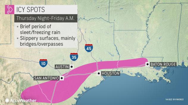
Very early on during the storm, the first area at risk from the late-week storm will be parts of Texas and Louisiana, where just enough cold air may catch up with moisture to produce spotty sleet and freezing rain late Thursday night to early Friday.
A winter weather advisory has been issued for the San Antonio area with winter storm warnings in place farther south, including Corpus Christi.
 |
"The potential icing event coming up for central and coastal areas of Texas and central and southern Louisiana will be a far cry from the disaster that occurred last winter," AccuWeather Senior Meteorologist Jake Sojda said, adding that the concern this time would generally be limited to bridges and overpasses, which are likely to cool down the fastest Thursday night.
Most surfaces are likely to be just wet, or even dry off in this case, following midweek temperatures in the 70s and lower 80s F. Still, the sharp turnaround in temperatures could feel jolting to many in those areas and AccuWeather forecasters advise motorists to exercise extra caution Friday morning from parts of the lower Rio Grande Valley to Houston and Baton Rouge, Louisiana, with an anticipated 40- to 50-degree temperature plunge coming.
For the latest weather news check back on AccuWeather.com. Watch the AccuWeather Network on DIRECTV, Frontier, Spectrum, fuboTV, Philo, and Verizon Fios. AccuWeather Now is now available on your preferred streaming platform.
