High winds to arrive ahead of severe storms Tuesday in Volusia-Flagler: What's expected?
Another round of severe weather arrives on Tuesday in Central Florida, with the potential for thunderstorms, high winds and potential tornadoes now anticipated by mid-morning in Volusia and Flagler counties, according to the National Weather Service in Melbourne.
Here’s what you need to know:
Potentially hazardous weather signals cold front arrival
Another strong cold front is forecast to move through the area on Tuesday, according to a hazardous weather advisory issued by the National Weather Service in Melbourne.
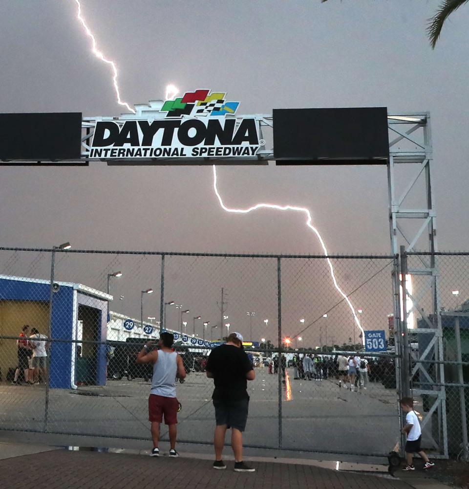
A band of strong to severe storms capable of producing thunderstorms, damaging wind gusts, as well as the potential for a few tornadoes, is forecast to move rapidly across the peninsula starting by mid-morning Tuesday, according to the latest NWS update.
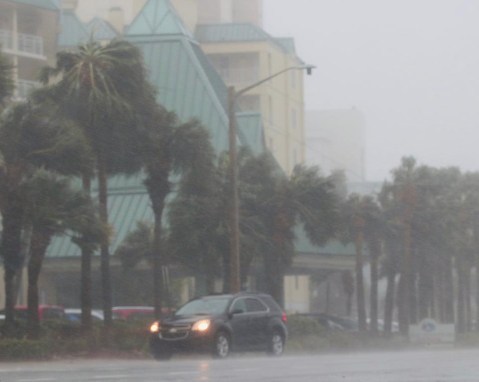
Southerly winds are expected to increase to 20-30 mph with gusts 35-45 mph in the late morning and afternoon ahead of thunderstorms coming later in the day, according to a post by the NWS in Melbourne on X, formerly known as Twitter.
While these winds are forecast to diminish in the late afternoon, the arrival of storms will maintain a wind threat into the evening, the NWS stated.
Also, on Tuesday morning, there were media reports of a tornado touching down near Panama City Beach on Florida's Gulf Coast. There, residents were under an assortment of hazardous weather advisories by Tuesday morning, including a severe thunderstorm warning, tornado watch, wind advisory, high wind warning, high surf warning and coastal flood advisory.
When is the worst weather expected in Volusia-Flagler?
In Volusia and Flagler, a high surf advisory was in effect on Tuesday morning through 7 p.m. for large breaking waves of 5 to 7 feet expected in the surf zone. Conditions also include rough choppy surf and a strong northward flowing longshore current with a moderate risk of rip currents expected.
In Volusia, a wind advisory also is effect from 8 a.m.-7 p.m. Tuesday in anticipation of south winds of 20-30 mph with gusts up to 45 mph expected ahead of strong to severe storms later in the day.
The advisory states that gusty winds could blow around unsecured objects. Tree limbs could be blown down and a few power outages may result.
Residents are advised to use extra caution when driving, especially if operating a high profile vehicle and to secure outdoor objects.
In Volusia and Flagler, the biggest potential severe weather is expected to start by late afternoon Tuesday.
How high are wind gusts expected to be in Volusia-Flagler?
The main storm threats associated with this band of storms will be strong, damaging wind gusts 60 mph and greater, a few tornadoes, frequent lightning strikes, and small hail, according to an advsiory issued early Tuesday.
Heavy rain will also be possible within the band of storms, but it will be moving quickly, so rain accumulations of only 1-2 inches are forecast. It's strongly advised that residents and visitors prepare ahead of this line of storms and stay weather aware Tuesday afternoon into overnight hours.
On Monday, a small craft advisory was scheduled to go into effect at 4 p.m. in Daytona Beach, according to the NWS. East-southeast winds were expected to be 15 to 25 knots and seas up to 7 feet.
In case you missed it: 'All of the sudden, the house started shaking': Palm Coast tornado victims share story
In addition, a gale warning is in effect at 10 p.m. Monday for southeast winds expected to be 25 to 35 knots with wind gusts up to 45 knots and seas 7 to 12 feet. The gale warning will expand to include the nearshore waters after 4 a.m. on Tuesday, the NWS stated.
What’s the forecast for the week ahead?
Here’s the NWS extended forecast for Daytona Beach:
Tuesday: Showers and possibly a thunderstorm after 1 p.m. Some of the storms could produce gusty winds and heavy rain. High near 78. Windy, with a south southeast wind 20 to 30 mph, with gusts as high as 40 mph. Chance of precipitation is 80%, dropping to 60% overnight.
Wednesday: Sunny, with a high near 61. West wind around 10 mph. Nighttime low around 45.
Thursday: Partly sunny, with a high near 64. Northwest wind 5 to 10 mph becoming northeast in the afternoon. A 40% chance of nighttime showers, with a low around 55.
Friday: Showers likely and possibly a thunderstorm. Mostly cloudy, with a high near 76. South wind around 15 mph, with gusts as high as 25 mph. Chance of precipitation is 60%, dropping to 40% at night with a low around 57.
Saturday: A 20 percent chance of showers and thunderstorms. Mostly cloudy, with a high near 67, nighttime low around 50.
Sunday: A 20% chance of showers. Mostly sunny, with a high near 64.
Here’s the extended forecast for Palm Coast:
Tuesday: Showers and possibly a thunderstorm after 1 p.m. High near 78. Very windy, with a south wind 21 to 28 mph, with gusts as high as 40 mph. Chance of precipitation is 90%. Severe nighttime storms also possible, with a nighttime low around 46.
Wednesday: Sunny, with a high near 61 and nighttime low around 42.
Thursday: Partly sunny, with a high near 63 and nighttime low around 52, with a 50% of nighttime showers.
Friday: Showers likely and possibly a thunderstorm. Mostly cloudy, with a high near 76. Nighttime low around 54.
Saturday: A 20% chance of showers. Mostly cloudy, with a high near 67. Nighttime low around 45.
Sunday: A 20 percent chance of showers. Mostly sunny, with a high near 64.
This article originally appeared on The Daytona Beach News-Journal: Volusia-Flagler forecast calls for storms, high winds, tornado risk

