Another storm brings weekend threat of flooding, severe weather to the South

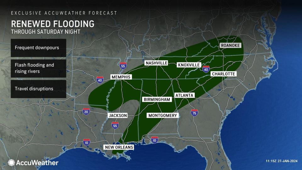


The waterlogged South will have to contend with one more moisture-packed storm this weekend that AccuWeather meteorologists warn will bring a renewal of stream and highway flooding and perhaps even a few gusty thunderstorms and tornadoes.
The prospect of more rain and severe weather in the region is a harsh one, as the region is still reeling from multiple waves of soaking downpours that moved through earlier in the week, resulting in over a foot of rain, dozens of waterways leaving their banks and damage from strong thunderstorm winds.
"This weekend's storm will be the caboose of a 'storm train' that has brought flooding and severe weather this week to areas from southeastern Texas to Alabama," said AccuWeather Senior Meteorologist Joe Lundberg.
 |
The first raindrops from this new storm began to fall across the Plains and along the northern Gulf Coast on Friday. Tapping into the rich moisture flowing out of the Gulf of Mexico, more rain and thunderstorms will continue to blossom through Saturday from Mississippi to the Carolinas.
Among the threats faced in the recent bout of storminess, the flooding rainfall aspect has dominated the conversation. That will continue to be the case as the region faces the final storm this weekend.
Over the past week, a large swath of real estate stretching from central Texas to the Gulf coast and northward through the Mississippi and Tennessee valleys has recorded more than 3 inches of rain. The heaviest, most repetitive downpours have occurred from eastern Texas to Louisiana, southern Arkansas and Mississippi, where rainfall estimates from NOAA's Advanced Hydrologic Prediction Service are between 6 and 15 inches since late last week.
 |
7-day multi-sensor observed precipitation across the South, as of Friday morning, Jan. 26, 2024. (NOAA/AHPC) |
Within this zone, Shreveport, Louisiana, recorded an impressive 6.85 inches of rain from Monday through Thursday while Jackson, Mississippi, was not far behind at 5.94 inches. That amount of rain is beyond what is typical for the entire month of January and was in addition to the wet first half of the month.
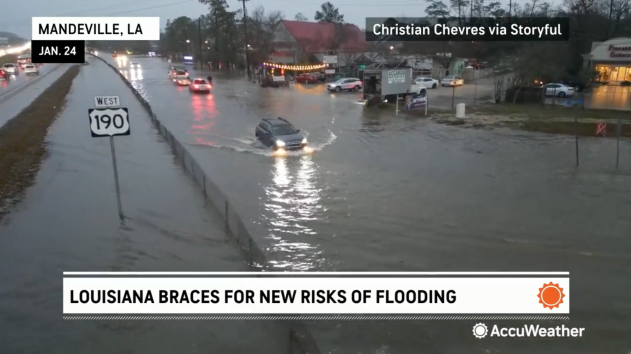
The torrential downpours led to dozens of flood warnings across the region, for low-lying areas, highways and rivers and streams. According to CBS News, emergency crews had to use boats to rescue people from more than a dozen homes in Mandeville, Louisiana, while TV station WGNO reported numerous road closures in other parts of the state.
 |
Flood watches and warnings issued by the National Weather Service across the South, on Friday morning, Jan. 26, 2024. (AccuWeather) |
AccuWeather meteorologists expect the area of heaviest rain with this last storm to be displaced a bit more to the north and east compared to the activity earlier this week, stretching more into the Southeast and even up the East Coast through Saturday night, but it will overlap in some areas.
"There are numerous rivers near or above flood stage from eastern Texas into Louisiana and Mississippi," said AccuWeather Senior Meteorologist Adam Douty. "The additional rain expected into the weekend can push these rivers even higher and lead to rises on other waterways."
Rain gauges will show 1 to locally 3 inches of rain from this last event from the New Orleans area to Birmingham and Montgomery, Alabama; Atlanta; Knoxville and Nashville, Tennessee; and even as far east as Charlotte and Raleigh, North Carolina. In some spots, heavy rain may fall quickly, heightening the risk of flash flooding, overwhelmed storm drains and flooded roads.
"This bout of rain and storms is not anticipated to bring as much rain as was seen across the region during the past several days," added Douty. "However, in a lot of areas, it will not take as much rain to cause flooding as it would have a week ago."
 |
While the heavy rain and flooding have caused significant disruptions to daily life, there will be long-term benefits. According to the latest U.S. Drought Monitor, which contains data through Tuesday, Jan. 23, 42% of Louisiana and 53% of Mississippi were experiencing extreme or exceptional drought, the Monitor's two most dire categories. That was down from 89 and 70 percent, respectively, from three months ago.
"Despite the prospects of good news in the long range, it is important to remember that, even if there is an ongoing drought, flooding can still happen in heavy rain," pointed out Douty.
 |
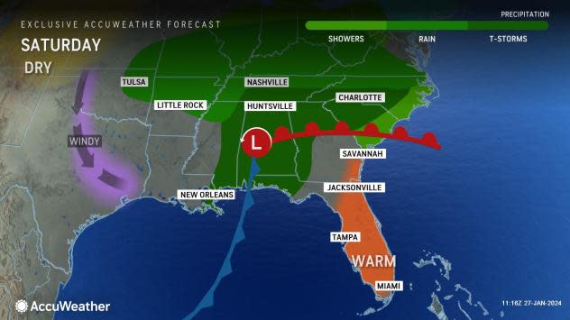
After soaking the South with heavy rain through the first half of the weekend, the storm's moisture will then march into the Northeast, where there can be a round of travel-disrupting, accumulating snow to end the weekend and start the new week.
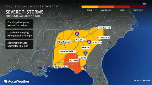
Amid the torrent of rain, a few thunderstorms have also become severe as storms have moved through the South in recent days. AccuWeather meteorologists warn that this will continue to be the case over the weekend.
"The best chance for severe weather with the next storm will be from Saturday into Saturday night from southern Mississippi all the way to the western Carolinas," said Lundberg. While downpours and flash flooding will remain far and away the biggest threat, a few storms can generate damaging wind gusts, hail and even an isolated tornado or waterspout.
Tornado watches were issued along the Florida Panhandle and far southwestern Georgia Saturday afternoon, along with special marine warnings that noted the potential for waterspouts along the coast and strong winds.
 |
Wind gusts from the strongest storms will be mostly between 60 and 70 mph, and the AccuWeather Local StormMax™ for winds is 80 mph, which is more than enough to cause damage to trees, power lines and even some structures. Travel at area airports and along portions of Interstates 10, 20 and 75 can be impacted from even non-severe storms. The greatest risk for a few tornadoes will be in central Alabama.
While it is the heart of winter, powerful thunderstorms can still occur, especially in this part of the country where the ingredients will sometimes come together just right.
"Unusually warm, moist air for January is being drawn northward from the Gulf of Mexico ahead of this storm," added Lundberg. "Combined with cool air aloft, it can cause thunderstorms to develop that can turn severe."
 |
Another, albeit smaller risk for gusty thunderstorms will exist before the storm and its associated cold front move past the East Coast on Sunday.
"As the front pushes across eastern North Carolina on Sunday, a few gusty thunderstorms cannot be ruled out," said Douty. AccuWeather meteorologists are also keeping an eye on the central Florida Peninsula, including the parks and resorts around Orlando, as another area where strong storms can form.
Fortunately, the storms will move swiftly for those with outdoor plans to end the weekend.
"The front is expected to push off the Carolina and Florida coasts around midday on Sunday, ending the threat for any storms by the afternoon and evening hours," added Douty.
Want next-level safety, ad-free? Unlock advanced, hyperlocal severe weather alerts when you subscribe to Premium+ on the AccuWeather app. AccuWeather Alerts™ are prompted by our expert meteorologists who monitor and analyze dangerous weather risks 24/7 to keep you and your family safer.
