Storm timeline: When will snow, heavy rain, damaging wind begin impacting Massachusetts?
Flood watches and a high wind warning have been issued for Massachusetts as another storm packing drenching rain and damaging wind gusts takes aim at the region after many communities were buried by more than a foot of snow on Sunday.
Track the storm on interactive radar
The Boston 25 Weather team has issued a Weather Alert for Tuesday evening into Wednesday with snow, heavy rain, flooding, and damaging wind gusts in the forecast.
This approaching system comes on the heels of a major weather event that prompted winter storm warnings and blanketed the region in snow.
Precipitation will arrive between 3 p.m. and 4 p.m. Tuesday ahead of the evening commute as an initial burst of snow at elevations.
“Even though it will be washed away by heavy rain, the evening commute could be quite slippery in parts of central Massachusetts and southern New Hampshire,” Boston 25 Meteorologist Spear wrote in her weather blog. “Only a coating to a few inches will fall before rain comes along.”
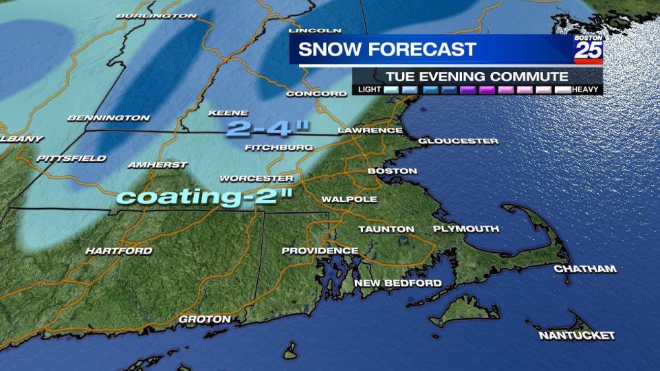
By 10 p.m., the snow will shift over totally to drenching rainfall, according to Spear.
“It’s going to pour overnight into Wednesday morning,” Spear said. “The heaviest rain goes probably to about 5 a.m. to 7 a.m.”
The National Weather Service has issued a flood watch for Franklin, Hampden, Middlesex, Essex, Hampshire, Norfolk, Plymouth, Bristol, Worcester, Berkshire, and Suffolk counties through Wednesday morning.
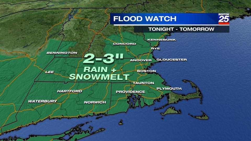
In a statement, the NWS said, “Excessive rainfall of between two the three inches falling Tuesday Night into Wednesday morning in combination with snowmelt may result in rapid stream and river rises. Snow-clogged drains may also contribute to the flood risk in poor drainage and urban areas.”
A coastal flood watch is also in effect for Barnstable, Dukes, Essex, Norfolk, Plymouth, Bristol, Nantucket, and Suffolk counties.
Boston 25 Reporter John Monahan braved the elements in Scituate as the coastal town faced winds and heavy rains. Power outages are expected overnight as the wind speeds increase.
The Massachusetts Emergency Management Agency reminded residents to clear snow, ice, and debris from storm drains and downspouts near their property to allow water to flow through.
As you shovel out, don’t forget to clear snow, ice & debris from any storm drains/downspouts near your property to allow water to flow through.
Another high-impact storm expected tomorrow night is forecast to bring heavy rain, which combined with snowmelt may lead to flooding. pic.twitter.com/HrnSMNPB2s— MEMA (@MassEMA) January 8, 2024
Last fall, many cities and towns saw extreme flooding, like in Leominster where basements were underwater, cars were stalled on roads and parking lots, and yards turned into lakes. Some homes were even on the verge of falling into sinkholes.
The NWS issued a high wind warning for Barnstable, Dukes, Essex, Plymouth, Nantucket, Bristol, and Berkshire counties.
A wind advisory is also in effect for Middlesex, Hamden, Franklin, Hampshire, Norfolk, Worcester, Suffolk, and Essex counties.
Wind gusts are already breaking 50 MPH on the Cape & Islands. Over 40 MPH in Providence and parts of the North Shore. Heck of a pressure gradient we're seeing across the region too pic.twitter.com/71LbAp93Gn
— Tucker Antico (@tuckerweather) January 10, 2024
Wind gusts of 50 to 70 mph are possible in the impacted areas from Tuesday evening through Wednesday afternoon.
“Because of these strong winds, you can see an elevated risk for power outages Tuesday night into Wednesday, especially along the coastline,” Spear said.
A second Weather Alert is in the upcoming seven-day forecast for Saturday, with more rain and wind expected.
For more on Tuesday’s storm, visit the Boston 25 Weather page for updates.
Download the FREE Boston 25 News app for breaking news alerts.
Follow Boston 25 News on Facebook and Twitter. | Watch Boston 25 News NOW

