Another wave of bitterly cold air has re-started the lake-effect snow machine through this weekend

On the heels of a wintry week, another gasp of bone-chilling air and snow will continue this weekend across the Great Lakes and Northeast, AccuWeather meteorologists warn.
"A reinforcing shot of cold air and a renewal of lake-effect snow are in store through the weekend," said AccuWeather Meteorologist Brandon Buckingham. "This follows what has been the coldest stretch of days so far this winter for residents of the Great Lakes and Northeast."
The wintry blast will ensure that the cold weather gear and snow removal equipment stay out for a few more days. In some areas, it will push weekly snow totals close to an incredible 7 feet, while AccuWeather RealFeel® Temperatures can, once again, drop to dangerously low levels well below zero.
 |
The lake-effect snow will closely follow a winter storm that will moved off the mid-Atlantic coast after dropping several inches of snow into Friday evening.
Lake-effect snow is generated from cold air moving over comparatively warmer lake waters. A shift in the direction of the wind behind the initial storm will not only generate these lake-effect snow bands but also result in the temperature drop that will last into the weekend. It can also send the snow to different areas compared to earlier in the current cold snap.
"Unlike the lake-effect event that unfolded in recent days in the west-to-southwest prevailing snow belts, a northerly wind this weekend will shift these bands into different areas," said Buckingham. "This predominant wind direction will bring very heavy snow to places like northwestern Pennsylvania and along the south shore of Lake Ontario."
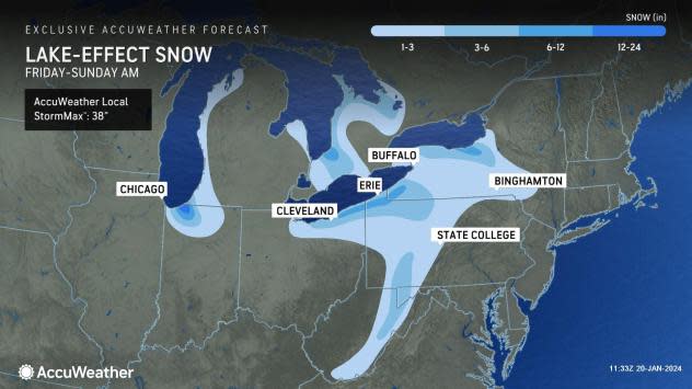
Several rounds of lake-effect snow blasted western New York from last weekend into earlier this week, dropping as much as 75 inches of snow over a multiday period in the Southtowns of Buffalo. While additional accumulations can push weekly snow totals in this area to close to 7 feet, heavier amounts will fall this time in places such as Michigan City, Indiana; Ashtabula, Ohio; and Edinboro, Pennsylvania; with an AccuWeather Local StormMax™ of 30 inches.
 |
Patrick Sahr shovels snow in Buffalo, N.Y., Wednesday, Jan. 17, 2024. City hall was closed, and school districts declared snow days. Travel bans were issued for several suburbs. (AP Photo/Carolyn Thompson) |
The lake-effect snow began on Friday morning downwind of Lake Michigan but downwind of lakes Huron, Erie and Ontario, the snow bands wasted no time setting up. The snow will diminish as the wind direction switches again, shifting farther east by Sunday morning.
In areas where the heaviest snow is forecast to fall, including parts of the Cleveland, Erie and Buffalo metropolitan areas and along stretches of Interstates 71, 80, 86 and 90, the white stuff can fall at an intensity where snow plows will struggle to keep up-up to 2 or 3 inches per hour for a time. The expected wind will also blow around the snow, further reducing visibility.
 |
Farther away from the lakes, snow showers and flurries can fly in places such as Pittsburgh and Binghamton, New York, deep into the weekend, resulting in light accumulations. While the larger cities along I-95 from Baltimore to Boston will avoid lake-effect snow, they will not avoid the cold winds.
"Even in areas removed from the lake-effect snow, the gusty winds in the wake of Friday's storm can lead to areas of blowing and drifting snow across a wide swath of the Northeast," added Buckingham. The proclivity for the snow to move around will be due to its dry, powdery nature.
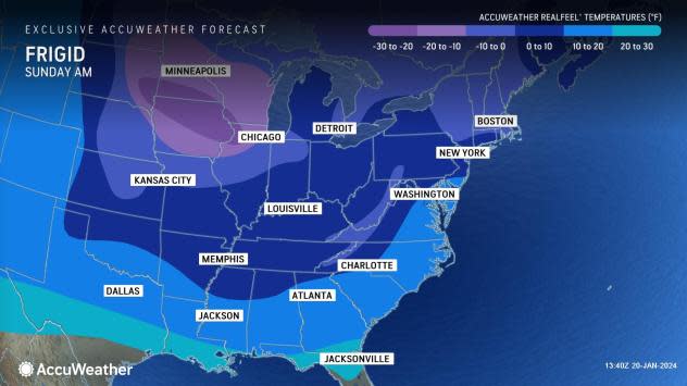
Adding to the dangers of traveling in lake-effect snow will be a bitter chill. The already cold weather will be reinforced by the change in wind direction, allowing temperatures to drop another 10-20 degrees or more through at least the first half of the weekend. This will result in temperatures mainly in the single digits and teens, and AccuWeather RealFeel® Temperatures as low as 20 below zero, increasing the risk of frostbite.
 |
For those growing weary of the cold air, there is some light at the end of the tunnel. A milder weather pattern should take hold over much of the Great Lakes and Northeast next week.
"After the bitterly cold air into this weekend, there are signs of a major warmup on the horizon next week," said Buckingham. "This means temperatures will finally rise above freezing early in the week and perhaps well into the 40s in some areas by midweek."
However, the upcoming thaw next week will present problems in the form of fog, ice and even more snow.
Want next-level safety, ad-free? Unlock advanced, hyperlocal severe weather alerts when you subscribe to Premium+ on the AccuWeather app. AccuWeather Alerts™ are prompted by our expert meteorologists who monitor and analyze dangerous weather risks 24/7 to keep you and your family safer.
