Answer Man: Radar serving Asheville, WNC, broken for 1 month? Are we weather-blind?
Usually the Citizen Times calls National Weather Service meteorologists curious about what the forecast holds in store, but this question had us calling to talk about broken gear.
Got a question for Answer Man or Answer Woman? Email Interim Executive Editor Karen Chávez at kchavez@citizentimes.com and your question could appear in an upcoming column.
Question: I follow AshevilleWX, Hunter Ward, on social media. He just posted this: “The KGSP radar which is the primary radar for the Asheville area will be down for the next month.” What is the KGSP radar and what does that mean for weather forecasts in Asheville? Will we not know when the next snowstorm or cold snap is coming?
Answer: Indeed, an important piece of weather tracking equipment that provides real-time weather information for Western North Carolina is broken.
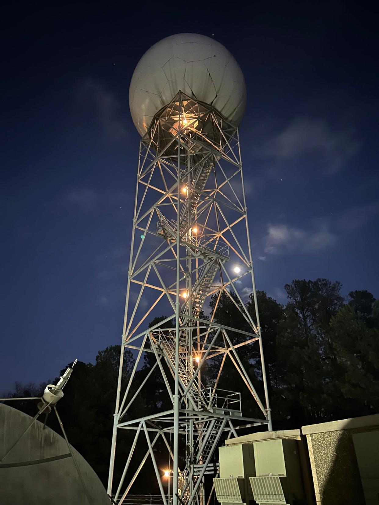
The National Weather Service-operated Doppler radar in Greer, South Carolina, at Greenville-Spartanburg International Airport, or KGSP, may be nearly 80 miles away from Asheville, but it’s one of the most important tools when it comes to providing real-time weather data.
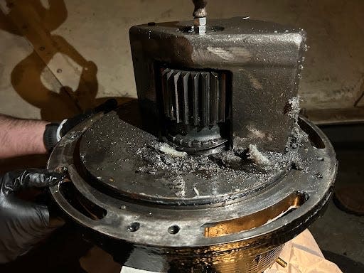
On Dec. 31, according to NWS warning coordination meteorologist Trisha Palmer, a 25-year-old piece of hardware called a bull gear on the radar tower gave out, crippling the tower’s ability to rotate its antenna since. When online, the tower picks up weather data in a 120-mile radius.
Related:It's so cold in Western NC, wind chill temperature at Mt. Mitchell beats its record low
Related:Answer Man: What is the coldest, hottest it’s ever been in Asheville? Mt. Mitchell?
Related:Answer Woman: Why is the Blue Ridge Parkway closed when it's warm and sunny in Asheville?
But, until at least the beginning of February, it will be down.
“We were going to actually replace it next month,” Palmer said. The tower was scheduled for routine updates in February — part of the NWS’s Service Life Extension Program designed to extend equipment life through 2040 — but it just happened to give out before those updates got underway.
“The problem is that the contractors have a schedule and they have a lot of other radar repairs,” said Palmer, who noted repairs will require a “very big” crane. “We've got to find out this week if we can move that. Either way, we're going to get the bull gear fixed and we're going to get the radar back up by Feb. 6.”
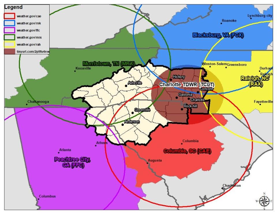
The tower’s radius covers a good portion of WNC. The other NWS radar tower has a radius that covers WNC over the mountains in Morristown, Tennessee. Naturally, the mountains create blockages for radar, which is like a beam that crashes into raindrops and snowflakes, converting that data into moving weather.
“This is a big deal,” said local meteorologist Hunter Ward on Facebook Jan. 5. Ward runs the 37,000-follower page Ashevillewx-Meteorologist Hunter Ward and ashevillewx.com where he uses his own skills and tools to track and report on local weather. “The KGSP radar which is the primary radar for the Asheville area will be down for the next month. We will rely on the KMRX radar which experiences significant beam blockage for many areas of WNC.”
It’s true, Palmer said. Mountains create beam blockage making it harder for the Morristown NWS radar to provide real-time information.
“That's just the way it is when you've got topography,” she said. “And we've got the highest topography in our forecast area east of the Rockies.”
Luckily, she added, January isn’t a “severe weather time.”
Moreover, a crippled tower doesn't necessarily spell a crippled forecast.
“The radar outage would have nothing to do with the reliability of forecast data,” Palmer said.“This has nothing to do with model data or forecast data. This is just real time observations and just one of the many observations.”
Asheville residents, she said when asked, have nothing to worry about in the event another cold snap slices through the region: NWS still has sufficient tools, resources and personnel to track temperatures.
Related:'Unacceptable,' 'Third-World'; legislators pan Asheville handling of water crisis
Related:Boil water advisory lifted for all Asheville water customers, western area water restored
“We use a total observation concept,” Palmer said, which includes citizen scientists with the Community Collaborative Rain, Hail & Snow Network — CoCoRaHS for short — automated observation sites, satellite observations and other tools.
Another tool is people who have phones and the mPING app.
The National Oceanic and Atmospheric Administration National Severe Storms Laboratory collects reporter information on this app to “fine-tune” forecasts, according to the app’s website.
Palmer said this is a very helpful resource for NWS regardless of outages.
“Radar or no radar, that’s still a huge help all the time because it's fascinating for us to see how the precipitation type changes. As winter weather moves in, it's hugely helpful for us.”
Ward agreed the temporary radar outage won’t necessarily hamper vital weather information needed to predict severe changes, but noted it would be nice to have another tower that provides radar information to the region.
“Weather enthusiasts and meteorologists in North Carolina have been huge proponents for getting another radar in the area,” he said in an interview. “We need one in Central North Carolina. … Like the Boone area you can't hardly ever see what's coming.”
It would take a study to figure out where exactly to place such a tower, but, hypothetically, Ward said he’d put it north of Hickory or in the Greensboro area.
Radars are supported by three federal agencies: NOAA National Weather Service, United States Air Force, and the Federal Aviation Administration, according to a news release from Palmer.
More information on the radar’s status will be forthcoming as repairs move forward.
Andrew Jones is an investigative reporter for the Asheville Citizen Times, part of the USA TODAY Network. Reach him at @arjonesreports on Facebook and Twitter, 828-226-6203 or arjones@citizentimes.com. Please help support this type of journalism with a subscription to the Citizen Times.
This article originally appeared on Asheville Citizen Times: Asheville, Western NC to lose some weather data due to broken radar

