Arctic air mass will bring hard freeze, wind chill warnings to area
Gadsden will be under hard freeze and wind chill warnings heading into Christmas weekend, which should be no surprise given what weather forecasters say is about to unfold over much of the United States.
A mass of arctic air will sweep into the area in the early hours of Friday morning, which according to the latest forecast discussion by the National Weather Service’s Birmingham office could send temperatures plunging by as much as 30 degrees in a few hours.
Amplifying that will be brisk winds that are likely to drive wind chills below zero at times and keep them in single digits until at least Saturday morning.
Etowah County is under a wind chill warning from midnight to noon Friday; a wind chill watch from hard freeze warning from noon Friday to noon Saturday; and a hard freeze warning from midnight Friday to noon Sunday.
After a high of 53 degrees on Thursday, the NWS predicted a low of 9 degrees for Gadsden Thursday night/Friday morning, with winds of 10 to 20 mph with gusts as high as 35 mph.
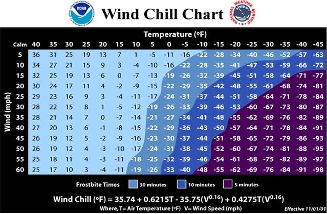
That brings the wind chill temperature — defined by the NWS as “how cold people and animals feel outside” — into the equation. The NWS forecast a wind chill as low as -5 degrees Friday morning.
According to the NWS, wind chill is “based on the rate of heat loss from exposed skin caused by wind as cold,” and also includes factors such as skin tissue resistance.
Increasing winds draw heat from the body, decreasing skin and, eventually, internal body temperatures and making it feel colder than the recorded temperature.
Based on the NWS’ wind chill chart, for instance, when it’s 15 degrees and the wind is blowing at 15 mph, the wind chill temperature is zero.
It will remain windy throughout Friday — 15 mph sustained and 30 mph gusts — when the NWS predicts a high near 22 and a low of 8, again with a potential wind chill of -5.
Saturday will still be brutally cold, with a high near 27 and a low of about 12, with 10 mph winds and gusts as high as 20 mph still causing issues. The high will finally top the freezing mark on Christmas Day, barely, at 33, but the low will remain in the teens at 14.
Temperatures will begin to "warm" on Monday, to a high of 39 and a low of 21, according to the NWS, and in one of those "only in Alabama" scenarios, Birmingham forecaster James Spann said during his morning video presentation on Wednesday that highs could be in the mid-60s by Dec. 30.
Measurable snow remains unlikely, according to the NWS, except in Alabama’s most northern and northwestern counties.
NWS forecaster Daniel Martin told the Montgomery Advertiser earlier this week that even though Alabama is in a La Niña, which generally means a warmer than usual winter, “these kinds of cold periods” can happen during those weather patterns.
Warming stations are already open through Friday in Gadsden, but local officials say they will review that time frame depending on the conditions.
Updates are available at www.shelteretowah.com; information also can be obtained from the Gadsden-Etowah Emergency Management Agency by email at ema@cityofgadsden.com, by Facebook message at https://www.facebook.com/GECEMA or by phone during business hours at 256-549-4575.
The current locations:
Family Success Center, 809 E. Broad St., Gadsden, during its regular hours of operation.
Freedom Center, 1601 W. Meighan Blvd., Gadsden, during its regular hours of operation; it could convert to an overnight shelter if other options are full.
Gadsden Public Library main branch, 254 College St.; East Gadsden branch, 802 E. Broad St.; and genealogy branch, 2700 W. Meighan Blvd., during normal hours of operation.
Salvation Army, 1101 First Ave., warming station and overnight shelter.
The Tuscaloosa News reported these tips from the NWS for dealing with cold of this magnitude:
Protect people: Make sure to bundle up and wear layers outdoors. Have extra blankets ready in case power goes out. Check in with family and neighbors — especially those who are more at-risk, such as people who are elderly or disabled.
Protect pipes: To prevent freezing and possible bursting of outdoor water pipes, pipes should be wrapped, drained or allowed to drip slowly.
Stay weather aware: Be sure to stay alert by checking the latest forecast.
Protect your plants: Know the temperature thresholds of your plants. If possible, cover your plants before sunset to retain heat.
Vehicle preparedness: Make sure your car has supplies, such as water and blankets in case you are traveling anywhere with icy roads and get stranded. Check to see if you need to fill up your gas tank before a cold weather event.
Protect your pets: Bring your pets inside.
This article originally appeared on The Gadsden Times: Gadsden area faces hard freeze, wind chill warnings
