Arctic blast to bring 10 inches of snow as Met Office issues amber weather warning
Heavy snow alerts has been issued for parts of the United Kingdom as an Arctic blast is set to freeze the country and bring travel disruption.
The Met Office has issued two amber weather warnings, the second most serious alert, for parts of England and Wales. Some yellow weather warnings for rain and snow will also be in effect across almost the entire country.
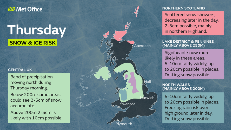
Up to 10 inches of snow could fall on higher ground above 300 metres in the Peak District and the southern Pennines, which are under an amber warning from noon until 6pm on Thursday.
In north Wales and north-west Shropshire, a separate amber warning for snow and ice will be in place from 8am to 3pm on Thursday, with up to 6 inches of snow expected in areas above 200 meters.
Met Office meteorologist Amy Bokota said an easterly wind meant that places “inland and higher up” were likely to see the most snow.
Some travel disruptions are also possible. The forecaster warned it was “safer not to drive in these conditions” unless necessary.
“The snow could cause some pretty poor driving conditions for parts of the Pennines and Wales, particularly through the afternoon and early evening,” Ms Bokota said.
“The cold snap is likely to affect vehicle breakdown levels, with faults such as flat batteries and wiper faults,” she added.
“Make sure that for your journey times you plan longer, especially in the snow,” Met Office chief meteorologist Kathryn Chalk said.
Untreated pavements and cycle paths may become impassable. Power cuts are possible and there is a good chance of some rural communities being temporarily cut off.
The freezing conditions are a result of an Arctic air mass pushing down over the UK colliding with a rain front moving north-east across England and Wales.
There are lots of warnings out for the remainder of the week for rain, snow and ice ⚠️⚠️
Take a look below for a summary 👇 and get more details here 👉 https://t.co/QwDLMfRBfs pic.twitter.com/J5s4WFEomE— Met Office (@metoffice) February 7, 2024
Yellow weather warnings are scattered around the country covering large parts in Scotland, England, Wales and entire Northern Ireland.
“It will be quite a short-lived cold snap for much of the UK, but continuing on a little bit longer through parts of northern England and Scotland into the early hours of Friday and the start of the weekend,” Ms Bokota said.
One yellow rain warning covers much of southern England and south-east Wales – including London and Cardiff – starting from 2am on Thursday to 6am on Friday, with 15-25mm likely and up to 45mm on higher routes.
Another yellow snow and ice warnings covers southern and central Scotland from 6pm on Thursday to 3pm on Friday. While in Northern Ireland, the warning starts from 10am on Thursday until 6pm on Friday. Up to 3-4 inches of snow could fall in both regions.

