Arctic Blast to Hit 240 Million People Across the U.S. With Freezing Temperatures and Weather Warnings
Cold weather is hitting large swaths of the country this week and many could experience “record colds,” according to the National Weather Service (NWS).
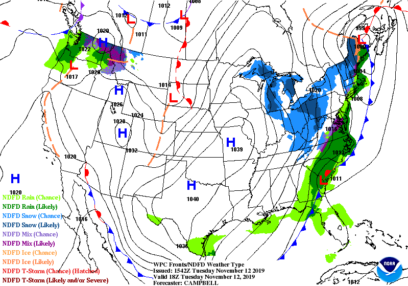
The NWS forecasts “widespread record cold spreading from the Plains eastward toward the East Coast,” spreading across the eastern two thirds of the United States. The cold blast will last from Tuesday Nov. 12 until Thursday Nov. 14.
Around 240 million people will face winter weather warmings, watches, and advisories, according to CNN.
The Midwest and parts of northern New England already experienced snow on Monday, brought on by the “arctic air mass,” per the Associated Press.
Which parts of the country are getting hit with cold weather?
“Record cold” temperatures will spread in the Ohio Valley and down into the southern Plains on Tuesday as the “arctic airmass” moves south and eastward, according to the NWS. By Wednesday morning, “record low temperatures” in the teens and 20s can be expected throughout most of the East Coast, the Ohio Valley, and as far south as the upper Texas coast. The NWS says it will “feel like the middle of winter for these areas.”
NWS predicted on Monday that more than 300 daily-temperature record lows could occur between Monday and Wednesday.
The cold has reportedly caused school closures or delays across the U.S., including in the Midwest, the Mid-South and even Texas.
UPDATE: Nearly every school in NW Ohio and SE Michigan is CLOSED. Dreams do come true kids. pic.twitter.com/nHQ2W9uHB7
— Chris Vickers (@ChrisWTOL) November 12, 2019
The NWS predicts that “Rain will likewise move rapidly across the Deep South and the Southeast today before the arctic chill arrives.”
According to the NWS, freezing temperatures have already hit the Midwest and are spreading as far south as Georgia and Texas.
A few record low max temps were set today:
Marshfield 19°
Oshkosh 23° (tie)
Rhinelander 17°
Wisconsin Rapids 21°#wiwx— NWS Green Bay (@NWSGreenBay) November 12, 2019
3 PM CST Temperatures:
Rhinelander, Wisconsin: 13°
Green Bay, Wisconsin: 22°
Barrow, Alaska: 25°
Anchorage, Alaska: 30°#wiwx pic.twitter.com/VJoUKxkSKS— NWS Green Bay (@NWSGreenBay) November 11, 2019
#Indy has dropped another degree. The record for the date is now 8°. This is the coldest temperature this early in the season on record. Next closest was 11° on November 3rd, 1951. #Brrr #INwx
— NWS Indianapolis (@NWSIndianapolis) November 12, 2019
The cold air arriving tomorrow has made the trip all the way from the Arctic over the past week! This shows where the air coming to ATL has come from according to our GFS model. It won't be as cold as it was when in the Arctic, temps will get into the 20s tomorrow night! 🥶 #gawx pic.twitter.com/o5tR7sds1k
— NWS Atlanta (@NWSAtlanta) November 11, 2019
A Wind Chill Advisory is in effect today for all of Deep South Texas. Strong winds combining with cold temperatures will make it feel like it is below 30F through much of the day. Remember to wear multiple layers when headed out! #coldfront #RGVwx #txwx pic.twitter.com/Awjqsy3mbZ
— NWS Brownsville (@NWSBrownsville) November 12, 2019
Are any parts of the country expected to get snow?
The NWS also predicts “a wide large swath of snow” from “Tennessee Valley, along the Appalachians and upstate New York into northern New England.” But a lot of the snow is expected to “taper off” later on Tuesday.
Also on Thursday a separate disturbance of air will move across the Pacific Northwest and spread snow through the interior sections of the Northwest and the north Rockies, creating “light accumulations,” per the NWS. On Wednesday the “light snow and mixed precipitation” will likely move on top of the central Plains and reach the Great Lakes on Thursday.
Here's a broad look at the areas currently forecast to be impacted by snowfall through midday Thursday.
Follow your local NWS office for detailed information. Find them at https://t.co/GWrG0hCgjd https://t.co/OFqZQaz2ij pic.twitter.com/dAKck9Fu7e— National Weather Service (@NWS) November 12, 2019
This morning, #GOESEast zoomed in on yesterday's #snowfall that covers an area from the #Midwest and the #OhioValley to northern #AR and northwestern #TN. Expect bitter #cold temps throughout the region as a #ColdFront sweeps eastward. #Snow ❄️
More: https://t.co/ufS1wXH1hm pic.twitter.com/EU1laikL7f— NOAA Satellites (@NOAASatellites) November 12, 2019
On Monday, the NWS predicted as much as a foot of snow in the interior of the Northeast of the U.S., and warned that wet snow would mix with freezing rain in update New York to north-central New England.
Here are the latest Key Messages associated with the early season winter storm impacting the Interior Northeast: pic.twitter.com/dO3Bzt9DIt
— NWS WPC (@NWSWPC) November 11, 2019
Wintry conditions have moved into the southern Plains and extend into the Northeast. Several inches of snow possible from the Mid-South to portions of the Northeast. A foot or more of snow is possible in the Great Lakes. pic.twitter.com/vHVpWfuTay
— National Weather Service (@NWS) November 11, 2019
Eastern US snowfall reports received by NWS forecast offices as of 1030 pm Monday evening. Snow continues to fall across most of these areas as of 1030 pm. pic.twitter.com/PBq2bmSYGD
— NWS Eastern Region (@NWSEastern) November 12, 2019
What’s the forecast for later in the week?
The NWS predicts the cold front will lessen up by Thursday, and the high pressure system of cold air moves north.
Rain will likely continue in Florida through Thursday, and the Gulf Coast can also expect rain beginning Thursday as air moves north from Mexico, per the NWS.
Will the cold weather affect flights?
On Monday morning, an American Airlines flight landing at Chicago’s O’Hare airport slid off the runway because of icy conditions, according to WBBM-TV. No one was injured.
BREAKING: @AmericanAir Flight AA4125 from @flyfrompti to @fly2ohare slides off runway in Chicago this morning. Passengers tell me everyone is OK, deplaned and on buses to terminal. Video: Joseph Lian from Greensboro. @ABC11_WTVD @ABC #ABC11 pic.twitter.com/rBwyqfVtiU
— Andrea Blanford (@AndreaABC11) November 11, 2019
CBS 2 reports that over 1,200 flights were also canceled on Monday at Chicago’s O’Hare and Midway airports because of winter weather conditions.
According to FlightAware, 261 flights have already been canceled within the United States on Tuesday.
How can you stay safe in cold weather?
Cold air has already settled over the Plains and the Midwest of the U.S., and at least four people reportedly died on Monday in connection to the dip in temperature. Three women were killed in a crash near Charlotte, Michigan, according to WLNS.com, and authorities reportedly said weather conditions were a factor. The Associated Press reports that one person was killed after a trick sold on nice in Kansas.
Here are the latest Key Messages associated with the early season winter storm impacting the Interior Northeast: pic.twitter.com/dO3Bzt9DIt
— NWS WPC (@NWSWPC) November 11, 2019
So how can you stay safe? The NWS recommends you minimize travel and stay indoors when possible. Make sure to keep your pets inside. If you have to travel, check your car’s tire pressure, antifreeze levels and defroster before you leave. Also make sure to keep a winter survival kit in your vehicle, which should include a blanket, a flashlight, and a first aid kid.
Another round of wintry precipitation is expected to push from the northern Plains into the Northeastern US over the next few days. How might you handle potentially slippery road conditions?
Delay travel? Find a different route? pic.twitter.com/XrIZyZs1Nz— National Weather Service (@NWS) November 12, 2019
The NWS recommends wearing layers of loose-fitting, lightweight warm clothing and a hat, as well as mittens rather than gloves. Try to cover your mouth to protect your lungs from the cold air and stay dry and out of the wind.
The NWS of Cleveland urges caution about the risk of a snow squall, or a sudden heavy snowfall with strong winds. If a driver is caught in a snow squall, NWS Cleveland urges drivers slow down, durn on their headlights, and avoid slamming the brakes.
This year is the second year where we will be issuing Snow Squall Warnings throughout the winter. Please take a minute to learn more about snow squalls and how dangerous they are. For more, visit: https://t.co/ZjFJT9yDZs#WinterPrep #PAwx #ThisIsCLE #CLEwx #NWS pic.twitter.com/xUEkrUgiF9
— NWS Cleveland (@NWSCLE) November 12, 2019
When a snow squall hits, visibility can drop to almost nothing in an instant. There is no safe place on a highway during a snow squall, but if you do get stuck on the road: reduce your speed, turn on your headlights, and don’t slam on your brakes! #WinterPrep #PAwx #CLEwx #NWS pic.twitter.com/xkSzv1zcQR
— NWS Cleveland (@NWSCLE) November 12, 2019

