Arctic cold front could bring snow squalls and winds up to 40 mph to Wisconsin
An arctic cold front is forecast to bring snow showers to Wisconsin on Friday, forecasters say.
Forecasters say some of the snow showers combined with gusty west winds could create snow squalls — quick bursts of brief, heavy, wind-driven snow that can send visibility down to almost zero and make driving difficult.
Here's how things are shaping up for Friday:
The cold front will move throughcentral Wisconsin during the late morning and early afternoon, the weather service said.
Winds are expected to gust from the west at 35 mph to 40 mph as the front passes.
That cold air and wind could kick up what are known as "convective snow showers."
Such snow showers occur when cold air interacts with energy and instability in the atmosphere, said Jaclyn Anderson, a meteorologist at the weather service office in Sullivan.
The result is often quick bursts of snow.
Exactly where and how intense the snow showers will occur is something that is notoriously difficult to forecast. Some areas may see brief bursts of moderate to heavy snow while other areas may see no snow showers at all.
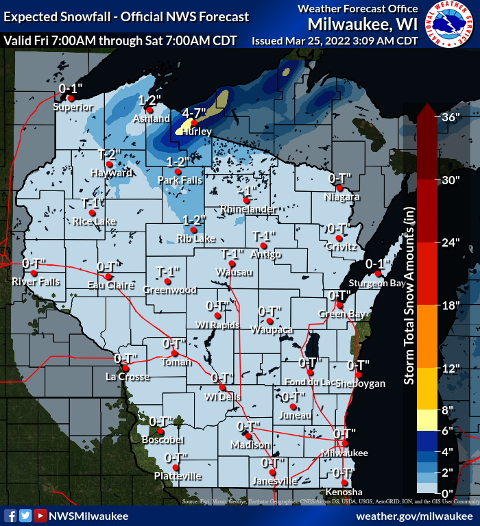
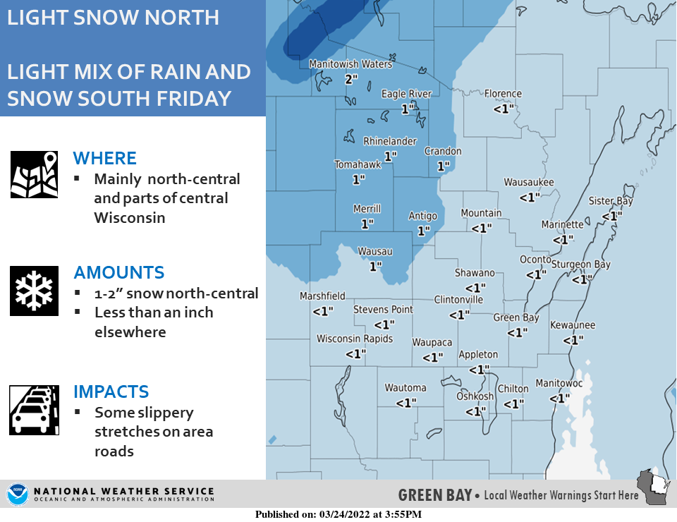
Most of northeastern Wisconsin won't see much snow accumulation, less than 1 inch. But parts of central Wisconsin could see up to an 1 inch of snow, according to the National Weather Service in Green Bay.
Snow squall warnings are fairly new
Don't be surprised if your mobile phone starts buzzing with snow squall warnings on Friday.
The weather service decided to begin issuing snow squall warnings because of, among other things, the number of big freeway pileups and crashes in the U.S. that have occurred with snow squalls.
A sudden burst of heavy snow in April 2021 caused a 100-vehicle pileup on I-41 in Washington County.
If any snow squall warnings were to be issued, they would alert via wireless emergency alert (WEA) system and show up on mobile phones, according to the weather service.
"Snow Squall Warnings are a new product that the (weather service) is sending out to try and warn motorists of dangerous, quickly changing conditions," the weather service said in November.
Cold weekend ahead
It will be cold in northern and central Wisconsin. The overnight low in Wausau for Saturday into early Sunday is forecast to be 10 degrees.
The Saturday night low in Green Bay is forecast to be 16 degrees. The Sunday high is expected to be 31 degrees with sunny skies.
Wisconsin weather radar

Can't see the radar? Click here.
Contact Joe Taschler at (414) 224-2554 or jtaschler@gannett.com. Follow him on Twitter at @JoeTaschler or Facebook at facebook.com/joe.taschler.1.
This article originally appeared on Green Bay Press-Gazette: Quick bursts of snow known as squalls possible in Wisconsin on Friday

