Arkansas River Basin snowpack below Colorado averages, but more storms could help
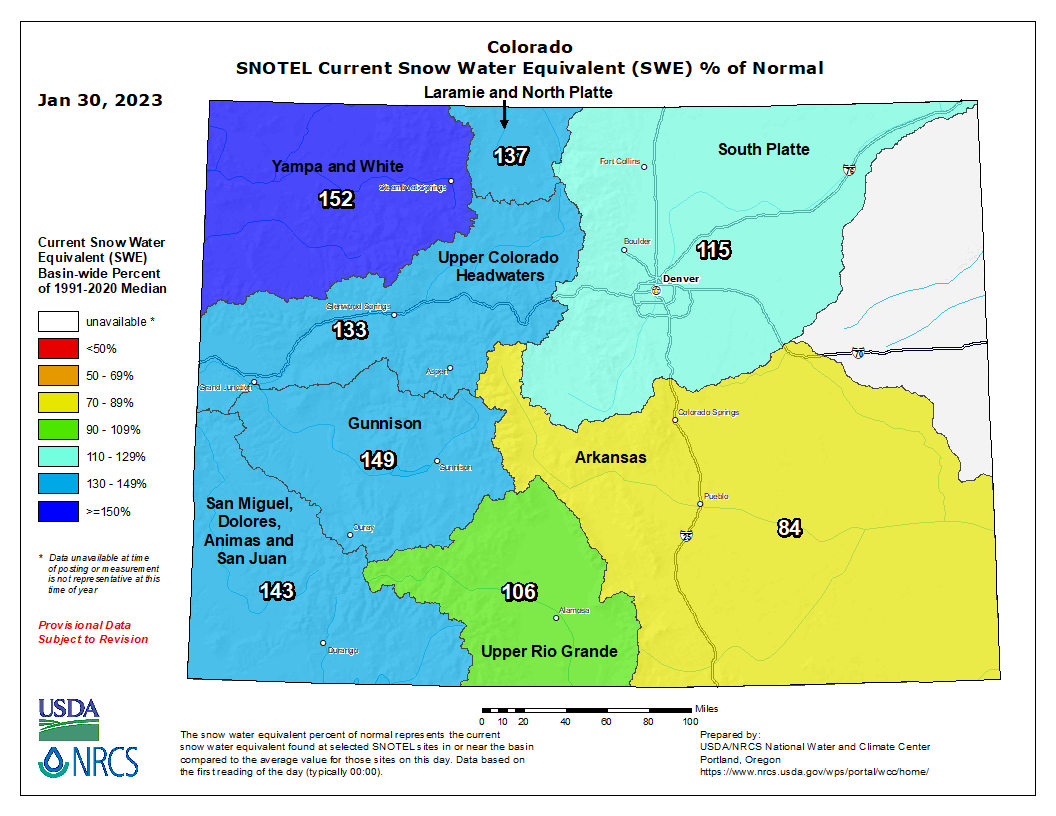
Much of Pueblo County is under “extreme” drought conditions per the U.S. drought monitor, and snowpack in the Arkansas River basin is at approximately 84% of its seasonal average for this time of year.
The region could use more moisture, but drought conditions have been worse in the past and the winter storm season is not yet over, said Stephen Hodanish, a senior forecaster with the National Weather Service of Pueblo.
The Arkansas River basin’s current snowpack levels, 84% of the seasonal average between 1991-2020, are lower than Colorado’s other river basins and the statewide average of 132%.
River basins west of the continental divide are faring especially well: the Gunnison River basin is at 149% of the seasonal average.
Hodanish said the western half of the state has gotten substantial snowfall from recent storms that have come from the Pacific Ocean, but the Front Range and southern Colorado have not received as much moisture.
Most of the drinking water on the Front Range, including Pueblo, is sourced from the Western Slope: an intricate network of tunnels moves snowmelt from the less-populated side of the Continental Divide to the ever-growing network of cities and towns along the Interstate 25 corridor.
Much of Pueblo County and the Eastern Plains are experiencing some level of drought, but most areas of the Western Slope are not under any drought conditions. “That’s a good thing,” Hodanish said.
More Pueblo news:Meet the 2 political newcomers running for Pueblo mayor
Colorado is faring better than some of its neighbors: parts of Kansas, Nebraska and Oklahoma are experiencing “exceptional” drought, the highest-intensity category on the map. Most of Utah is experiencing some extent of drought, including “extreme” drought in the central part of the state.
The state has been experiencing a “megadrought” for the past 23 years amid a warming climate and rapid population growth.
"Since the turn of the century, we're seeing an increased frequency in the droughts that we're experiencing and an increase in the severity of those droughts," said Assistant State Climatologist Becky Bolinger.
Hotter temperatures decrease the moisture in the atmosphere, which can also lead to reduced precipitation.
"The atmosphere wants to take more water from the surface because of those warmer temperatures ... and that just increases those deficits that you might be experiencing from precipitation," Bolinger said. "Southeast Colorado is an area that precipitation can be very hit or miss and it is very easy to build up a precipitation deficit when you add on those warming temperatures that we've been experiencing."
After a recent cold snap and snowstorm that brought a few inches of snow to Pueblo, temperatures will rise within the next week, Hodanish said. The “next chance” for precipitation is early next week when a Pacific storm could bring some moisture to the region.
More:Gas prices are soaring in Pueblo and throughout Colorado. Here's why
Pueblo and the surrounding region have historically received more precipitation in the late winter and early spring months from storms coming up from New Mexico and the Four Corners region, he said.
Bolinger said that precipitation in the upcoming months will be "critical" for southeast Colorado. The forecast for the next few months is "up in the air" but models indicate that there could be slightly less than average precipitation.
April is one of the most important months for precipitation, Bolinger said, because that's when the snowpack levels usually peak.
Anna Lynn Winfrey is a reporter at the Pueblo Chieftain. She can be reached at awinfrey@gannett.com or on Twitter, @annalynnfrey.
This article originally appeared on The Pueblo Chieftain: Arkansas River Basin snowpack currently below Colorado averages

