Asheville breaks heat record June 13. NWS says more record heat could come
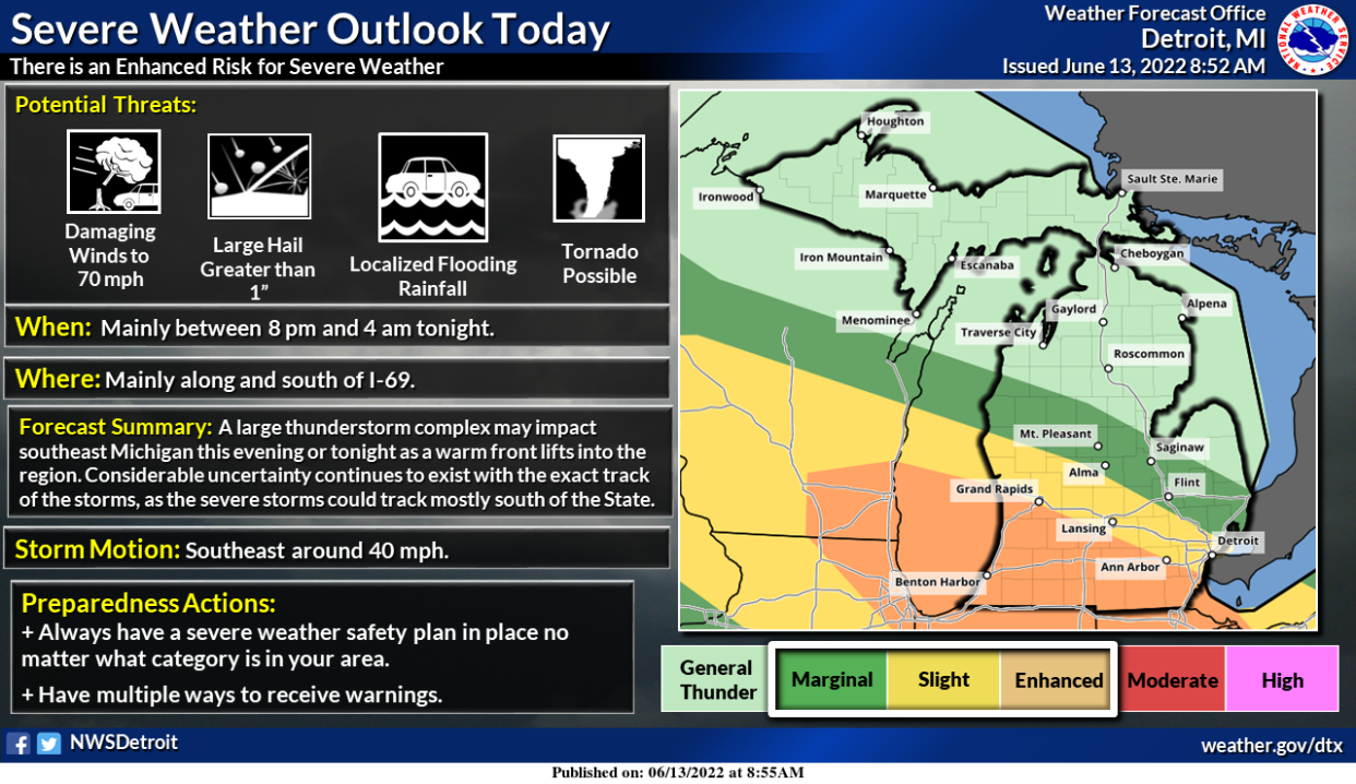
Temperatures in Asheville reached a record high on Monday at 92 degrees, surpassing the previous record high of 91 degrees set in 1894, and the record heat is not over just yet.
Asheville is currently experiencing record-level heat, and according to the National Weather Service, the high today, June 14, of 92 degrees would match the previous record set in 2016. Tomorrow, June 15, is not much better, with the forecasted high of 94 degrees set to beat the 1954 record of 93 degrees.
National Weather Service Meteorologist Doug Outlaw said this current bout of heat is due to the current weather pattern. Western North Carolina, eastern Tennessee and upstate South Carolina are currently experiencing extreme levels of heat due to the position of the upper-level ridge, an area of relatively high pressure in the atmosphere.
In simpler terms, Outlaw explained that jet streams—strong upper level winds—move west to east, with cool air to the north of the stream and warm air to the south in an oscillating motion reminiscent of waves. This boundary of warm and cool air moves northward or southward depending on the time of year.
The upper level ridge, currently centered over this region, resembles a cul-de-sac, trapping in the heat.
The current weather pattern may be responsible for this record level heat, but Outlaw said the current weather is “not normal because it’s an extreme.”
Despite an early start to the heat this summer, Outlaw said the current weather pattern has no implications for the rest of the summer or the summers to come. Yet he did note: “We didn’t get this hot this early last year.”
Fortunately, the projected 50-60% chance of precipitation for June 15-16 will provide a short reprieve from the heat until the weekend cool front arrives Friday, June 17. The forecast for Saturday and Sunday are clear skies and low-80 degree weather.
Unfortunately, Asheville will return to 90 degree weather starting early next week.
Tips to keep cool and signs of heat exhaustion
Extreme temperatures, specifically extreme heat, can be very dangerous if the proper precautions are not made. The Buncombe County Department of Health and Human Services has a number of steps to follow in order to remain safe and stay cool:
• Be sure to turn on the air conditioning in your home, if available, or spend the day in an air-conditioned building, such as the public library, a restaurant or a store.
• Drink plenty of fluids, but avoid alcohol, caffeine and sugary beverages as they can lead to dehydration.
• Take cool showers.
• Wear lightweight, light-colored clothing.
• Stay out of the sun as much as possible.
• If you must be out in the heat limit outdoor activity to the mornings and evenings. Take breaks every hour, preferably in shady locations if possible.
• Protect yourself from the sun by wearing a hat and sunscreen over SPF 15.
• Most importantly, become familiar with the signs of heat exhaustion and heat stroke. Heat exhaustion presents itself through heavy sweating, fatigue, muscle cramps, clammy skin, nausea, vomiting and fainting. In the case of heat exhaustion, drink water, move to a cooler location, lie down and apply cool, wet clothes to your body. If the symptoms persist, seek medical attention immediately.
Symptoms of heat stroke are a body temperature of 103 degrees or higher, a rapid and strong pulse, hot, red, dry or moist skin, and possible unconsciousness. Call 911 immediately as this is a medical emergency.
This article originally appeared on Asheville Citizen Times: Asheville, NC weather: Monday heat breaks record, tips to stay cool

