Asheville's 1st on-ground heat mapping study with NOAA; Where are hottest places in city?
ASHEVILLE - Days like the sweltering ones that are baking the Asheville area this week, and headlines of record-heat around the country, bring the face of climate change and an ever-warming planet into sharper focus.
National Weather Service Meteorologist Christiaan Patterson told the Citizen Times that their average recorded temperature for the month of July between 1991-2020 is 85 degrees. This year, their average temperature for the week of July 24 is 88 degrees, a scorching reminder of the gradual increase in global temperatures.
But while we know that the Earth — and Asheville — is getting hotter, one local environmental group is out to show how not everyone feels the heat equally.
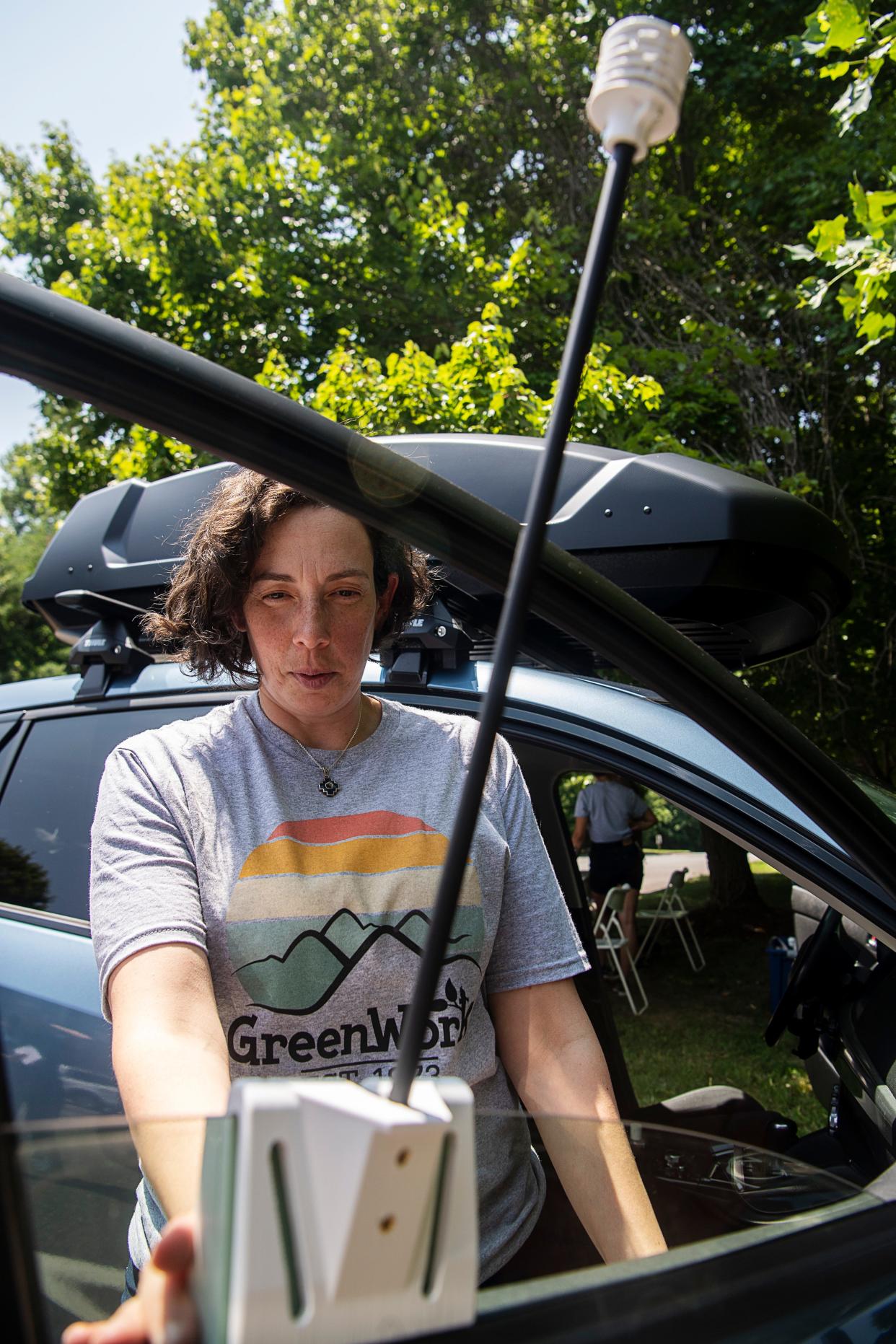
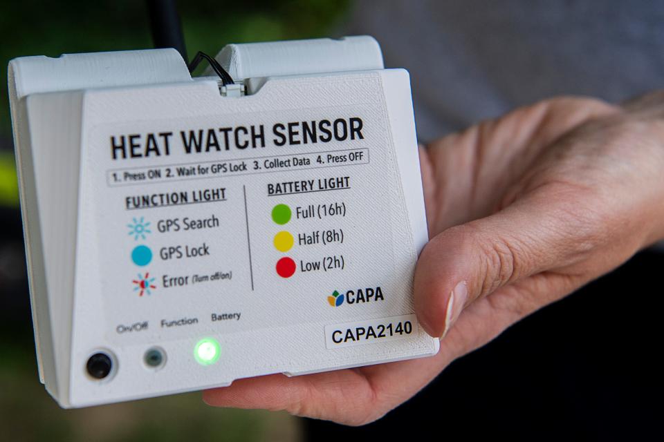
Asheville GreenWorks completed a heat mapping survey of the city July 24, the results of which will allow the nonprofit to provide data to the city that may inform decisions on how to protect its most vulnerable residents. Roughly 60 volunteers braved July temperatures to hunt down the valuable information, meeting in the sunny parking lot of the U.S. Fish and Wildlife Service office to travel Asheville roads in a fleet of vehicles marked with GreenWorks magnets and specialized heat sensors.
Asheville is one of 18 cities so far to receive the opportunity to undergo a heat mapping survey coordinated by the National Oceanic and Atmospheric Administration Climate Program Office, the interagency National Integrated Heat Health Information System and CAPA Strategies LLC.
Nicole McNeill, marketing and communications director for GreenWorks, took a break from greeting volunteers in the blazing sun to explain what they’re measuring.
“We're taking temperature and humidity data, and the purpose is to identify the hottest streets in the greater Asheville area. So what we did to actually determine where to study happens is we took satellite data. We looked at where is extreme heat already an issue, and that's where we're trying to dig into more details.”
More: Asheville 1 of 18 cities in heat-mapping campaign; GreenWorks to lead study
The National Weather Service helped GreenWorks determine the best day on which to take the data by pulling historic weather data, which showed that the week of July 24 was historically the hottest week of the year in Asheville.
Working on a day chosen for its estimated high temperatures didn't scare off the roughly 60 volunteers who worked in hour-long shifts to collect the data over the course of a single day. Window-mounted heat sensors recorded temperatures as the volunteers drove through heat-vulnerable parts of Buncombe County including Asheville, Woodfin, Swannanoa, Black Mountain, Candler and Arden.
The data collected will open doors for further projects from GreenWorks — and the community as a whole. Some uses of the data will include:
Identification of cooler and hotter areas.
The creation of an interactive color-coded map highlighting heat disparities across neighborhoods.
Mapping six health conditions vulnerable to heat impact.
Pinpointing neighborhoods with residents more susceptible to heat-related health issues to guide future outreach plans to address chronic health concerns.
Identifying the best locations to plant trees.
More: Asheville ranks on list of cities most likely to see impact of 'climate migration'
The World Health Organization states that people with conditions that are cardiovascular, respiratory, cerebrovascular and diabetes-related are particularly vulnerable to extreme heat. In communities with high heat that have residents with these health issues, GreenWorks hopes to help facilitate important changes through projects including strategic tree planting.
“In extreme heat, a well-placed tree could save someone’s life,” former GreenWorks Executive Director Dawn Chávez stated in a recent news release.
Asheville has helped to fund GreenWorks nurseries that grow trees including oaks, maples, sycamores and river birches for planting in these vulnerable urban areas. Ideally, McNeill said GreenWorks would contribute to an “urban forest master plan,” a holistic, specified guide to preserving Asheville’s trees and planting new ones.
“As part of its climate municipal Climate Action Plan, the City of Asheville has made it a priority to restore tree canopy in places where those trees are really kind of an important part of the climate resilience for those neighborhoods,” McNeill said. “So the one of the purposes of this data is to help identify where are the real priority locations that where we should be planting trees?”
High heat areas related to housing discrimination
According to past data collected by GreenWorks, there is a connection between high heat levels and discriminatory housing practices like redlining and urban renewal. Many of the areas surveyed by volunteers are affected by these issues.
“There is a very strong correlation between heat and this housing discrimination,” McNeill said. “Those are communities that have lost a lot of trees, that have a lot of new pavement, and they have a lot of vulnerable populations.”
Ashiya Gillette, youth environmental leadership program assistant, spoke to the Citizen Times before climbing into a GreenWorks truck to collect data for the cause. Gillette has come to understand that the low-income communities often affected the most by extreme heat simply don’t have the option to spend time seeking solutions.
“They don't have the time to vouch for having green spaces,” Gillette said. “And so I think that's one reason why there are less green spaces, they don't have the time to go out and campaign or resources to reach out.”
As an area with many microclimates, heat levels in Asheville vary widely based on a number of factors. With GreenWorks’ new data, they hope to be able to provide a closer look at these factors and their effects, and take another step toward a healthier community.
GreenWorks and its partners will analyze data this fall in order to create the map and other resources. In November, they will make the heat data available to the public and to other researchers.
More: Asheville fills long-awaited urban forester position. Who got the job, what will they do?
More: Answer Woman: Why aren't there shade trees at Malvern Hills Pool in West Asheville?
Iris Seaton is a news intern for the Asheville Citizen Times, part of the USA TODAY Network. Please support local, daily journalism with a subscription to the Citizen Times.
This article originally appeared on Asheville Citizen Times: Asheville heat mapping seeks heat-vulnerable areas of city

