Atlantic heats up: Tropical rainstorm brewing in the Gulf to join already active basin


Throughout the upcoming week, AccuWeather meteorologists will be tracking a multitude of features across the Atlantic Basin. These storms will span from the Cabo Verde Islands just off the west coast of Africa all the way to the Gulf of Mexico.
Some systems, such as Emily and Gert, will fade in a matter of a couple of days without bringing impacts to land. Others, such as Franklin and a tropical rainstorm in the Gulf of Mexico will have much more substantial impacts to lives and property.
 |
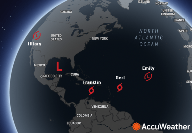
Tropical systems at 11 a.m. EDT on Aug. 21, 2023 as shown on the AccuWeather.com Hurricane Tracker. From left to right: Tropical Rainstorm Hilary, a Tropical Rainstorm in the Gulf, Tropical Storm Franklin, Tropical Storm Emily. |
Of immediate concern for the United States, a tropical wave tracked westward over the Florida Peninsula throughout the day on Sunday, which allowed for enhanced showers and thunderstorms to move into the region, creating rough surf and strong rip currents. This wave, dubbed a tropical rainstorm by AccuWeather this past weekend and Potential Tropical Cyclone 9 by the National Hurricane Center at midday on Monday, is forecast to move westward across the warm waters of the Gulf of Mexico and stands a high chance of developing into a short-lived tropical depression or tropical storm as it nears South Texas into Tuesday.
 |
"This feature will not have much time to develop before it likely moves into South Texas, although it will be moving across very warm water which can aid in rapid development," explained Pydynowski.
Locations along the Texas Gulf Coast are currently facing levels of moderate to extreme drought, according to the U.S. Drought Monitor. Cities such as Corpus Christi, Texas, have not recorded any measurable rainfall in August so far. Meanwhile, Brownsville and McAllen, Texas, have only observed a trace of precipitation to date.
Regardless of if this feature organizes into a tropical depression or tropical storm, an influx of tropical moisture will still spread inland across areas of South Texas and far northeastern Mexico from Monday night to early Wednesday as a tropical rainstorm. Given the dry conditions present, the crops and depleted reservoirs in this region would benefit from a stretch of wet weather.
 |
Some areas of southern Texas can observe a general swath of 1-2 inches of rain from Monday night to Wednesday morning as this energy shifts over the region. In locations where the most persistent downpours occur, totals can reach between 2-4 inches, which would be the most substantial rainfall observed in this area in the last several months. The last time this area recorded close to 1 inch of rainfall over the course of a few days was during the first week of June.
The heaviest rainfall associated with this feature is expected to occur in northeastern Mexico. The AccuWeather Local StormMax™ for this event is 12 inches. A slight northward shift in the track could bring the heaviest rain along parts of the Lower Rio Grande Valley and the mountains around the Big Bend area of Texas.
Have the app? Unlock AccuWeather Alerts™ with Premium+
In southern Texas, areas that receive persistent downpours early this week could face localized flash flooding as this feature tracks over the region. Locations along the coast could face an elevated risk for flooding, along with poor-drainage areas farther inland.
In addition to impacts from ample rainfall, residents can notice a slight decline in daytime temperatures across South Texas. Following an extended stretch of maximum temperatures trending several degrees above the historical average since roughly mid-June, locations such as Brownsville and Corpus Christi can briefly drop a few degrees below typical late-August values.
 |
Winds associated with the tropical rainstorm will ramp up along the Texas Gulf Coast from Monday night to Tuesday. Gusts can range from 40-60 mph during this timeframe with the AccuWeather Local StormMax™ of 70 mph.
Forecasters have rated the tropical rainstorm as less than 1 on the AccuWeather RealImpact™ Scale for Hurricanes in the United States and Mexico due to the risk of flooding rainfall, coastal wind impacts, rough seas and strong rip currents.
 |
The National Hurricane Center named Tropical Storm Franklin late Sunday afternoon as a low-pressure system had formed in the Caribbean, about halfway between Puerto Rico and Venezuela in South America.
 |
"This feature will bring an increase in rainfall across Puerto Rico and Hispaniola this week as it makes a more northward turn and eventually moves into the southwestern Atlantic," explained AccuWeather Senior Meteorologist Dan Pydynowski.
In the long term, it is possible that after moving over the open waters of the Atlantic, Franklin could take a northwestward turn toward Bermuda. Should this occur, it is possible for the system to later be drawn toward Atlantic Canada. Regardless, Franklin may be an active tropical system for many days should it survive the trip around the mountainous Greater Antilles.
Tropical Storm Emily organized roughly a thousand miles west-northwest of the Cabo Verde Islands Sunday morning with peak winds of 50 mph. Forecasters say that it will take on a northwesterly track through midweek before curving northward, gradually losing wind intensity as it travels over the open waters of the Atlantic Ocean.
On Sunday, tropical storm-force winds extended outward from Emily nearly 200 miles, nearly the equivalent of the boundary length of the South Carolina coastline. But, as of the midday hours on Monday, Emily was becoming poorly organized and transitioning into a tropical rainstorm.
Shipping interests in the Atlantic Ocean near the path of Emily should closely monitor the storm's position and intensity as it transitions to the northwest.
During Sunday night, the Atlantic gave birth to yet another tropical storm.
One of many areas over the basin that AccuWeather meteorologists have been monitoring for development has organized enough to become Tropical Storm Gert.
 |
A current view of Gert continues to show a relatively poorly organized cluster of showers and thunderstorms a couple of hundreds of miles east of the northern Leeward Islands. Through Monday, Tropical Storm Gert is expected to track to the west and gradually lose wind intensity as it approaches the northeastern Caribbean Islands.
Conditions in the path of Gert may only allow a short life span as a tropical storm. Forecasters expect a quick transition to a tropical rainstorm early this week prior to approaching the islands.
Areas of the northern Leeward Islands can have rounds of downpours from Monday afternoon to Tuesday.
AccuWeather forecasters are now calling for a moderate to high chance of development early this week for not one tropical wave but several pieces of energy churning from the central Atlantic to the Gulf of Mexico. Following a relatively quiet July in terms of tropical activity across the Atlantic Ocean, the remaining weeks of August are beginning to paint a vastly different picture.
 |
A view of the AccuWeather Enhanced RealVue™ Satellite across the Atlantic basin on Monday, August 21, showing numerous tropical features showing some level of promise for development this week. Tropical Storm Franklin is located southeast of Hispaniola, while Tropical Storm Gert is churning to the east of the Leeward Islands. |
Two tropical waves, one near the Cabo Verde Islands and another expected to emerge off of the west coast of Africa in the coming days, will pose a medium and low risk for formation from early to later this week.
 |
Forecasters say that even though conditions are ripe for development across portions of the basin, there are certain factors that storms will have to overcome in order to organize.
"Despite the fact that the ocean waters are abnormally warm, we will need other factors to come together for storms to develop. Wind shear, which is an increase in wind speed with height above the Earth's surface, is expected to be a limiting factor for development in some parts of the Atlantic basin," explained AccuWeather Senior Meteorologist Michael Doll.
Want next-level safety, ad-free? Unlock advanced, hyperlocal severe weather alerts when you subscribe to Premium+ on the AccuWeather app. AccuWeather Alerts™ are prompted by our expert meteorologists who monitor and analyze dangerous weather risks 24/7 to keep you and your family safer.
