Atmospheric River bringing steady stream of rainfall to Northwest US
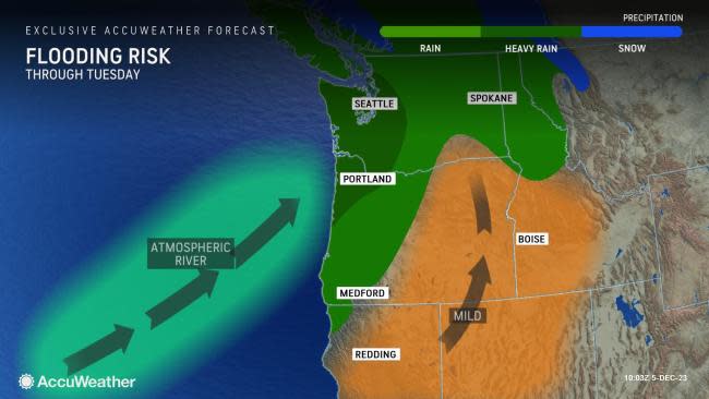


An atmospheric river that has streamed into the Pacific Northwest over the last few days has soaked the region with rounds of rainfall and blanketed mountain ranges with feet of snowfall in some cases. Forecasters warn that additional wet weather will spread across the region into midweek.
The latest round of rain that began on Sunday will continue through Wednesday. AccuWeather meteorologists anticipate that locations across Washington, Oregon, Northwest California, northern Idaho and western Montana will pick up anywhere from an additional 1-2 inches of rain to 4-8 inches along the coast. The AccuWeather Local StormMax™ for rainfall is 18 inches.
There have been numerous reports from the start of the weekend of flooded roadways, travel disruptions, rock and mudslides from Northwest California to western Washington. Residents are warned that additional rain to target the Northwest through Wednesday could further worsen conditions for locations already impacted by the deluge of rainfall over the previous days.
 |
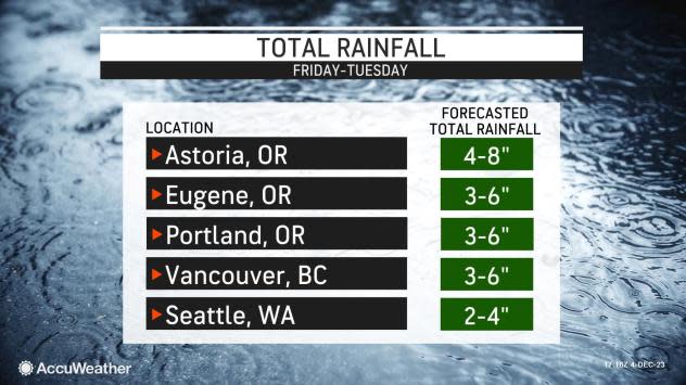
The highest population centers of the Pacific Northwest, Seattle and Portland, Oregon, could potentially total a month's worth of rain in the first six days of December as the prolonged stretch of rain continues.
"As of Tuesday morning, 2.99 inches has fallen in Seattle since the start of the month, while Portland has recorded 2.48 inches. Both cities are expected to receive an additional 2-4 inches of rain through Wednesday. The historical average rainfall for the month of December is 5.72 inches in Seattle and 5.77 inches in Portland," explained AccuWeather Meteorologist Elizabeth Danco.
Over 1.36 inches of rain were recorded on Monday alone in Seattle, with an additional 0.06 inches being recorded in Portland.
 |
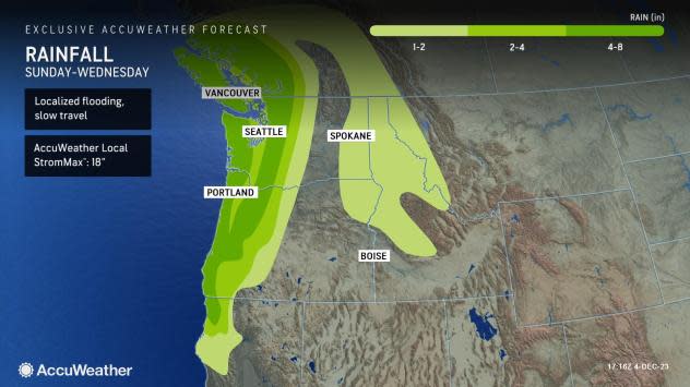
Flood warnings, watches and advisories were put in place for numerous counties across western Washington and Oregon through Wednesday night due to the steady stream of rainfall that will continue to spread inland.
"The combination of liquifying snow at rather high elevations, combined with torrential rain will have small streams and rivers that flow out of the Cascades, Olympics and Coast Ranges in Washington and northern Oregon surging rapidly into Wednesday," AccuWeather Senior Meteorologist Alex Sosnowski said, adding, "Due to the rapid rise of these streams, dangerous and life-threatening conditions may evolve."
 |
This image shows the water level forecast from National Weather Service hydrologists along the Skagit River, near Concrete, Washington. |
Some of the rivers in western Washington that will experience rapid rises into Tuesday night include the Skagit, Snoqualmie, Snohomish, Grays and Nisqually.
These areas are not strangers to ample amounts of rainfall over a short period of time, especially during the winter months from November to January. However, locations across western Oregon and Washington are currently enduring levels of moderate to severe drought, according to the U.S. Drought Monitor.
Cities such as Seattle have endured a relatively dry summer, setting the stage for the drought to set in. Observations from Seattle showed that they collected approximately 2.51 inches of rain from May through the end of August this year when the normal precipitation during this timeframe is nearly double that at 4.67 inches.
Forecasters say that although the generous rainfall totals expected over the upcoming days may be impactful in terms of travel disruptions, road closures and major flooding, the persistent rainfall could gradually help to improve the drought conditions.
 |
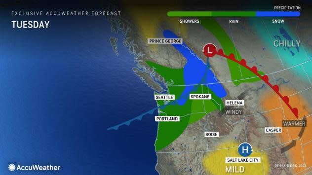
In the wake of rounds of snow that have turned the Northwest mountains into a winter wonderland and impacted travel across passes such as Willamette, Santiam, White and Snoqualmie late last week into the weekend, snow levels have risen significantly as warmer conditions set in since Sunday.
"Rising temperatures through Wednesday can lead to snow melting, especially in the Cascades where over a foot of snow has fallen. The snowmelt, in addition to the heavy rain Monday and Tuesday, can lead to flooding concerns and dangerous travel, especially in the mountains and foothills," explained AccuWeather Meteorologist Haley Taylor.
Have the app? Unlock AccuWeather Alerts™ with Premium+
Danco also added that along with the flooding risk, heavy rain falling in the mountains amid rising temperatures could cause the snowpack on steep mountain slopes to become more unstable, increasing the risk of avalanches.
The Northwest Avalanche Center issued avalanche warnings on Saturday and Sunday, stating that areas along the slopes of the Washington Cascades, Mount Hood, Stevens Pass and Snoqualmie Pass would face a level four-high avalanche danger.
 |
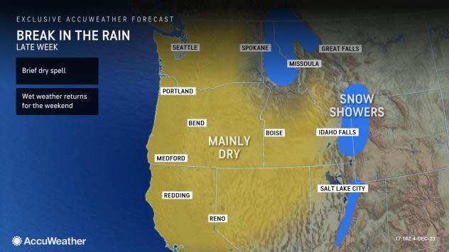
Forecasters say that although the steadiest rain will taper off late Wednesday, there will likely be a break in the lingering damp conditions by Thursday night.
"Looking ahead to later this week, a storm moving into the Northwest can bring colder air back into the region on Thursday, allowing for temperatures to drop closer to the historical average. However, the stormy pattern should shut off," stated Taylor.
Mainly dry conditions are expected to continue on Friday, but another round of rain and mountain snow can sneak back into the Pacific Northwest by late Friday into Saturday.
 |
Want next-level safety, ad-free? Unlock advanced, hyperlocal severe weather alerts when you subscribe to Premium+ on the AccuWeather app. AccuWeather Alerts™ are prompted by our expert meteorologists who monitor and analyze dangerous weather risks 24/7 to keep you and your family safer.
