Atmospheric river to dump rain on Fresno region. How it will affect weekend plans
Less than two days after a winter storm dumped almost two-thirds of an inch of rain on the Fresno area, forecasters with the National Weather Service say more heavy rain is coming to the central San Joaquin Valley this weekend, along with snow in the nearby Sierra Nevada.
Forecasters say the storm won’t be as cold as the system that hit the region Thursday.
“This is going to be a warmer atmospheric river event with moisture coming from the south to the north,” J.P. Kalb, a meteorologist at the NWS Hanford office, told The Fresno Bee on Friday afternoon. “Much of the moisture is coming in from the central Pacific Ocean.”
The forecast anticipates the first rain and snow to begin falling at about 10 p.m. Friday night, with the storm continuing to dump precipitation on the area until it tapers off Monday morning, Kalb said. The storm will also bring winds expected to gust to 20 to 25 mph on the Valley floor to as much as 50 to 60 mph in the mountains.
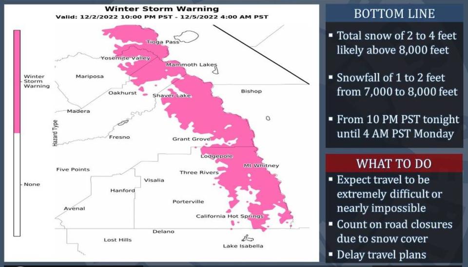
This storm will be warmer compared to Thursday’s system, but NWS forecasters issued a winter storm warning effective Friday night into early Monday morning for the Sierra Nevada range from Yosemite National Park southward into the mountains east of Tulare County.
Heavy Sierra Nevada snowfall is expected at times throughout the weekend , and accumulations could reach as much as 2 feet at elevations between 7,000 and 8,000 feet, and as much as four feet at elevations over 8,000 feet.
“The majority of precipitation associated with this storm system will fall Saturday and Saturday night,” forecasters reported Friday. “Snow levels will start at around 7,000 feet Friday night, before dropping to about 5,000 feet Sunday.”
The high winds coming along with the snow could make mountain travel dangerous.
On the Valley floor, “we are looking at 0.75 to 1.75 inches of rain for most of the Valley,” Kalb said, with lesser volumes at the south end of the Valley in Kern County and southern Tulare County.
The heaviest rainfall is expected in the Sierra foothills, where “intense showers are possible” between early Saturday morning and early Sunday morning, forecasters said. “Rainfall rates of around one in ch per hour are conceivable, which could result in localized flooding.”
Once the system clears the Valley, forecast models suggest the prospect of freezing overnight temperatures Wednesday and Thursday. Kalb added that there are indications the region could see another storm come in late next week, “but it’s a little too early to know right now.”

