Atmospheric river forecast this weekend; snow levels lag behind last year’s totals

LAS VEGAS (KLAS) — A forecast issued Friday by the National Weather Service Weather Prediction Center contains the magic words: atmospheric river.
“An atmospheric river is forecast to bring heavy precipitation, including mountain snow, to the Northwest and the northern Rockies this weekend. Low snow levels at the onset are expected to rise markedly by the latter half the weekend. Impactful snows are likely downstream as ample moisture and energy moves into the central Rockies,” according to forecast discussion on the Weather Prediction Center website.
The Pacific Northwest could get 12 inches of snow at higher elevations, with several feet by late Saturday along the higher peaks.
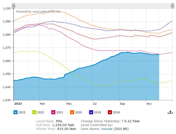
Last year, the western U.S. rode waves of atmospheric rivers to better-than-normal snow conditions in the mountains. The resulting snowpack in the Upper Colorado River Basin peaked at 160% of normal, helping to refill Lake Mead, Lake Powell, and smaller reservoirs in the Upper Colorado River Basin. The Sierra Nevada was hit even harder, reaching 237% of normal.
This weekend’s storm won’t be as strong as the January storms that buried the mountains and soaked the valleys. It will be farther north, and if it does dip further south, only a few inches of snow are expected in the central Rockies — snow that will be long gone soon, melting before winter takes hold.
Monitoring the snowpack won’t get serious for another month or two as climatologists look ahead to the anticipated peak on April 1. There’s still plenty of time for storms to bring winter snows to satisfy the thirsty Southwest. About 40 million people rely on Colorado River water, and attention turns to snow this time of year. Here’s a look at current conditions:
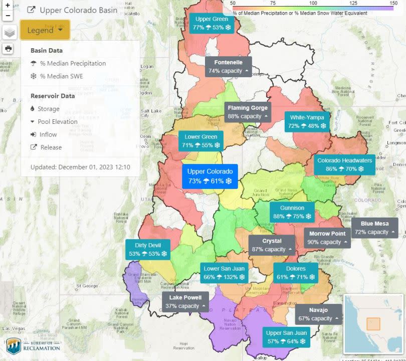
Currently, the “snow-water equivalent” (SWE) measured in the Upper Colorado River Basin is at 61% of normal.
Last year, the heavy storms hit around Christmas and repeated frequently. Early season storms had SWE levels at 164% on Nov. 1, 2022, but that shrunk to 113% three weeks later. By Dec. 29, levels were up slightly to 117% when the action really picked up in January. Another major factor: temperatures. Last year, snowpack accumulated as it stayed cold in the mountains.
Call it good fortune or dumb luck, it arrived when the nation’s two largest reservoirs, Lake Mead and Lake Powell, had dropped to about a quarter full. Going into this winter, Lake Mead is 34% full and Lake Powell is at 37%.
Relying on the weather
Should we worry that we’re only at 61% now? It’s early, and what happens by April 1 literally depends on the weather. El Niño’s impact is expected to bring warmer temperatures to the north, which could melt snow faster.
A year ago, atmospheric rivers bailed out the Lower Colorado River Basin states — Nevada, Arizona and California — but there’s no certainty that will happen again.
Conservationists and climate experts have reminded the public that climate change is here to stay. The World Meteorological Organization warned Thursday that 2023 is all but certain to be the hottest year on record, up 2.5 degrees from pre-industrial times. Those averages are important because even the slightest change over many years can spell doom for plants and animals that make up critical components of the globe’s ecosystems.
We watch the snowpack because it feeds the Colorado River. But real control over the water shortage isn’t likely to come from a few good years of snowfall. More likely, it will come from smarter use of the water that we’ve got.
To that end, new agreements announced Friday by California water agencies will help keep Lake Mead’s level higher.
New conservation agreements
The largest user of Colorado River water is the Imperial Irrigation District, providing farms in Southern California with the water to grow crops. The district has agreed to forego delivery of 100,000 acre-feet of water — that’s 32.5 billion gallons — keeping that amount in Lake Mead this year.
The agreement includes about $77.6 million in Biden administration payments that will fund projects for water conservation, water efficiency and protection of critical environmental resources in the Colorado River System this year.
A U.S. Bureau of Reclamation news release said the federal government is continuing to work with the Imperial Irrigation District on agreements for 2024 through 2026.
Another one-year agreement announced Friday involves the San Diego County Water Authority, keeping an additional 50,000 acre-feet in Lake Mead. The agreement is expected to bring $15 million to $20 million in savings for the agency.
A Politico investigation this week said the Biden administration is paying water districts to change habits they have already changed — effectively inflating the price of future agreements.
The agreements figure into short-term reductions in the use of river water. That’s important because Reclamation Director Camille Calimlim Touton has said there’s more water promised than actually exists. The 33-year “megadrought” has taken a heavy toll, and by 2050, the Colorado River’s flow will likely be 20% lower than it was in the mid-1900s.
Touton’s agency is in the process of drafting a new plan that will take effect in 2027.
In the meantime, conservation proposals submitted by Nevada, Arizona and California are providing a foundation that has stabilized the lake levels.
For the latest news, weather, sports, and streaming video, head to KLAS.

