Heavy snow, rain to blast West Coast states with travel disruptions

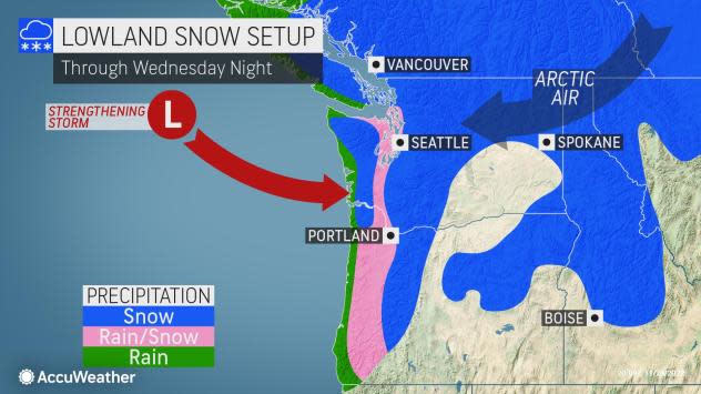


A quick-moving stream of moisture that will blast areas of the Pacific coast this week could cause major travel disruptions as it produces heavy snow, drenching rain, flooding and strong winds, AccuWeather meteorologists warn.
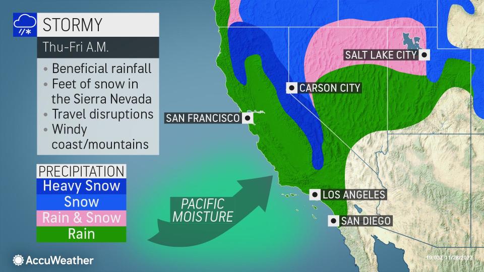
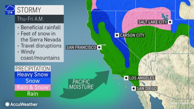
The moisture will continue to take aim at much of the West Coast and move steadily southward through Thursday, before weakening by Friday prior to reaching Southern California. The setup can lead to excessive amounts of rain and snow in a short period of time in the northern and middle portions of the Pacific coast.
 |
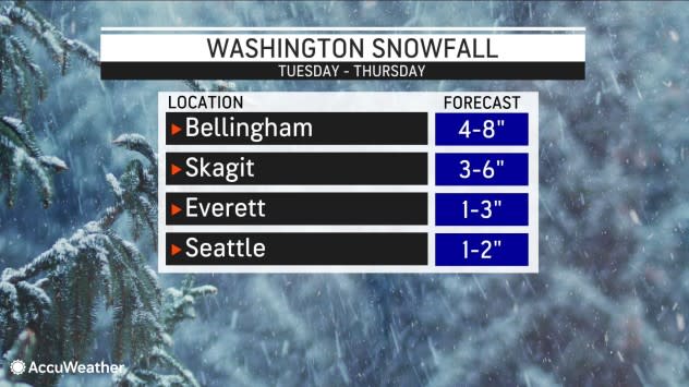
The precipitation from the storm is likely to be heavy for a period of eight to 12 hours with the worst conditions likely in western Washington into Wednesday evening, forecasters say. Top reports of snowfall neared double-digits in Stevenson and up to two inches accumulated in the western Washington city of Duvall, as well as in Longmire and Neah Bay.
Before precipitation changed over to rain, even Seattle-Tacoma International Airport recorded 0.9 of an inch of snow on Tuesday. This was Seattle's first measurable snow of the season. A mere 0.2 of an inch typically falls during all of November in the Emerald City.
 |
In western Oregon, the storm will hit hard from Wednesday through Wednesday night. From late Wednesday night to Thursday evening, the storm will hammer Northern California as it progresses slowly to the south.
Travel-snarling snow is likely in the intermediate and high elevations of the west-facing slopes of the Cascades as the main part of the storm and the stream of moisture drops southward. There is a chance that the major passes in the Cascades, including Snoqualmie, could close for a time due to rapidly accumulating snow.
A general 1-2 feet of snow will fall at pass levels in Washington and Oregon with locally higher amounts and several feet of snow likely over the high country. Snow could fall at the rate of several inches per hour for a time.
As is often the case with many storms that move in from the Pacific, a surge of warm air will occur and limit and perhaps prevent much snow from falling right at sea level.
However, due to the anticipated intensity of the precipitation close to the onset of the storm, the forecast around Seattle is tricky with the likelihood of an inch or two of snow and the potential for a heavier accumulation should rain change back to snow Wednesday night.
 |
Snow could also quickly pile up to several inches over the hilltops in the Interstate-5 corridor near and south of Seattle. A few hundred feet in elevation can make the difference between mostly rain and a bit of slush to 6 inches of snow and slippery travel.
Warm air is likely to have more time to reach areas farther south at low elevations in southwestern Washington and western Oregon, including the Portland area. There can be a brief period of wet snow or mixed rain and wet snow at the conclusion of the storm.
Rain will be substantial and could be heavy enough to lead to urban and small-stream flooding. Motorists should be on the lookout for rockslides and other debris flows.
Strong winds will add to travel difficulties for a time, especially for those flying into and out of the region. Gusts can be strong enough to break tree limbs and lead to sporadic power outages in coastal areas and along the western slopes of the Cascades.
Farther south in Northern California, the storm will pack a punch during the second half of the week.
"While the rain and mountain snow will be beneficial from a drought standpoint, enough can fall to lead to travel delays and disruptions," AccuWeather Meteorologist Haley Taylor said.
Long-term drought conditions range from moderate to exceptional based on the latest conditions from the United States Drought Monitor.
 |
During Thursday, as rain spreads southward along the coast and over the Sacramento Valley of California, snow will waste no time falling at a heavy rate in the Coast Ranges, Siskiyous and northern Sierra Nevada.
Travel will become slippery and difficult over Siskiyou Summit, along I-5, in southern Oregon on Thursday morning. Road closures are possible.
Snow will reach Donner Pass, California, along I-80 on Thursday and will continue into Thursday night with the potential for enough to lead to major travel delays and perhaps even a road closure for a time. A general 1-3 feet of snow is likely in the northern and central Sierra Nevada with locally greater amounts over the high country and at some of the ski resorts.
 |
The bulk of the rain will fall on the San Francisco and Sacramento areas on Thursday. While the rain may not be as intense as areas farther north along the Pacific coast, it can still lead to significant runoff, slick driving conditions and even ponding on some roads.
Rain is forecast to reach Los Angeles and San Diego, and the lower south and west-facing slopes of the mountains from Thursday night to Friday. While the rain will not be nearly as intense as that of areas in the Northwest and in Northern California, it can still lead to slow commutes due to slick roads, poor visibility and some runoff.
Snow levels are likely to remain above Cajon and Tejon passes in Southern California, but some of the ridges and peaks in the region could receive a few inches of snow on Friday, Taylor said.
 |
A couple of rain showers may survive the trip over the mountains and reach the deserts in Southern California on Friday afternoon and night as well.
Want next-level safety, ad-free? Unlock advanced, hyperlocal severe weather alerts when you subscribe to Premium+ on the AccuWeather app. AccuWeather Alerts™ are prompted by our expert meteorologists who monitor and analyze dangerous weather risks 24/7 to keep you and your family safer.
