Pineapple express delivers soaking rains in B.C., elevates flood, avalanche risk
A pineapple express will usher in several rounds of rain to B.C.'s southern and central coast this week.
Initial rainfall reports from the first round are trickling in on Sunday. More than 50 mm of rainfall was recorded across Metro Vancouver, while the city's airport documented 40 mm of precipitation. That made it the latter's rainiest day in the month since Jan. 3, 2019 (54.8 mm).
More rainfall is on the way, considerably raising the flood potential this week. The pattern is also conducive to an elevated avalanche risk.
DON’T MISS: El Niño is hanging strong—but a big change is on the way
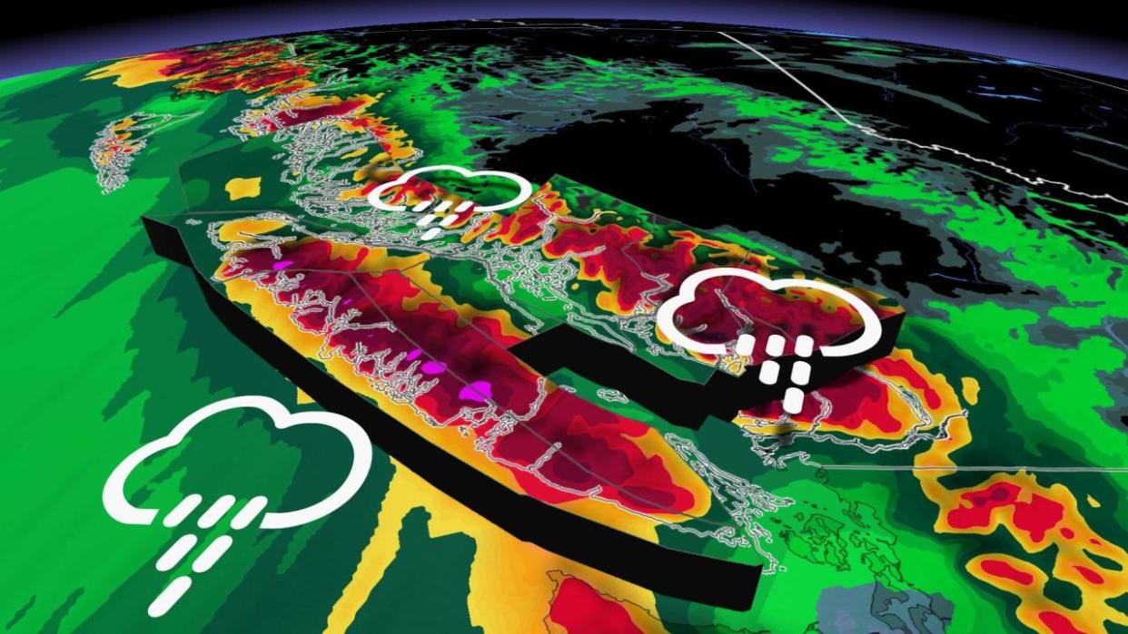
Series of storms threaten the coast with excessive rains
A steady parade of storms rolling through the northeastern Pacific Ocean will train an atmospheric river on coastal B.C. through the first half of this week.
The tropical moisture aiming for the West Coast is a bit of evaporated paradise heading to the region straight from Hawaii –– a classic pineapple express setup for the region.
Each storm will tap into this vast reserve of moisture aloft to fuel heavy rainfall across the region. Disruptions began this weekend with the arrival of heavy rain on Saturday evening.
RELATED: Backcountry enthusiasts beware as weather warms, experts cite avalanche risk
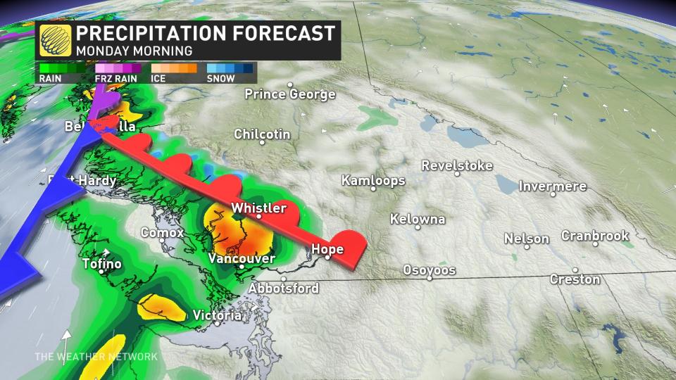
Conditions rapidly improve Sunday morning, but then quickly deteriorate in the evening again. This pineapple express will target more towards central and northern Vancouver Island, and the Sunshine Coast.
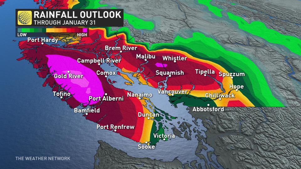
Communities most at risk include Tofino, Port Alberni, Powell River, Gibsons, and Sechelt. Close to 200 mm is forecast to fall in 24 hours across western Vancouver Island, which would put the region at risk for flooding and mudslides.
The hazard with this setup is that the atmospheric river isn’t really moving anywhere. It’ll remain in place and fuel heavy rain across southwestern B.C. through early Tuesday before the ribbon of moisture begins slumping southeast.
By the time the atmospheric river weakens Monday night, more than 200 mm of rainfall is likely across the higher terrain along western Vancouver Island. Other regions that could accumulate heavy rainfall include the Sea-to-Sky Corridor, where up to 150 mm of mild rainfall is forecast through Tuesday afternoon.
The freezing levels are concerning. The deep, tropical moisture is more bad news for ski resorts along the North Shore and Vancouver Island, as freezing levels will jump above Whistler by peaking higher than 2500 metres into this week.
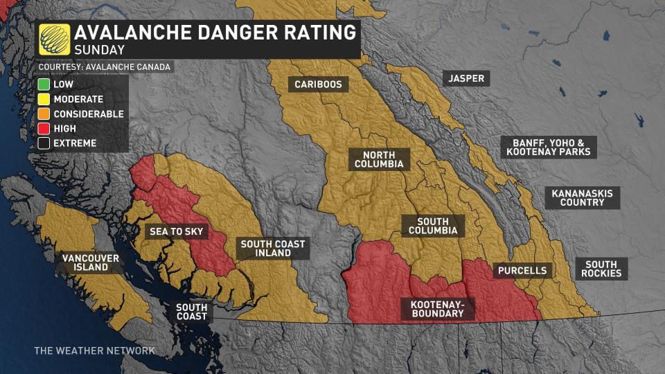
Combined rainfall and snowmelt will lead to a flooding risk around the mountains, as well as creating an unstable snowpack that will enhance the potential for avalanches in the backcountry, to considerable levels in many areas, along with mudslides.
MUST SEE: Get ahead of disaster: Six tips to manage flooding
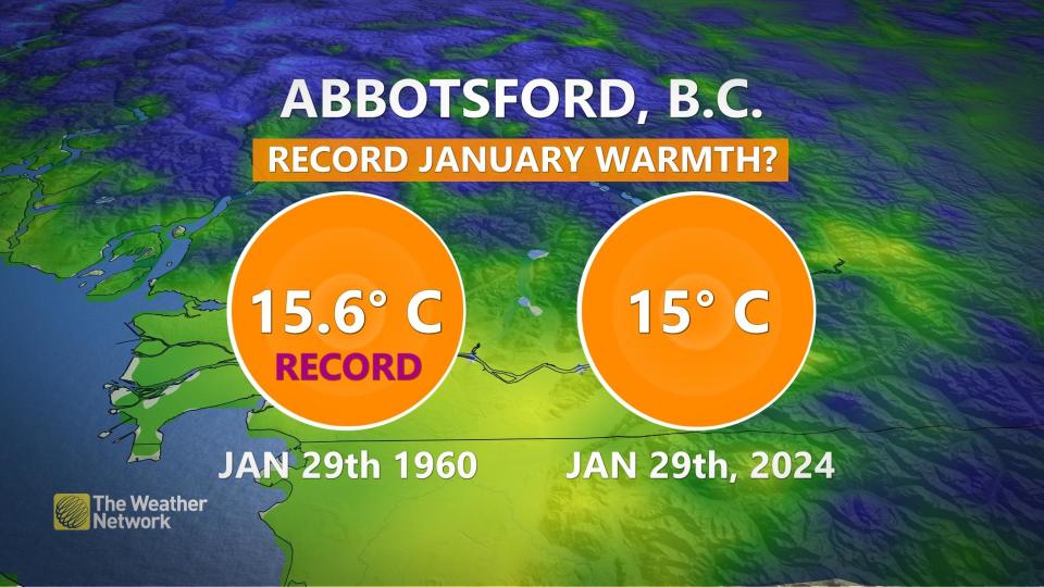
The strong and mild southwest flow mean temperatures on Monday will be in the low teens across southern Vancouver Island and Metro Vancouver, up to 10 degrees above seasonal. A couple of stations may record temperatures as warm at 15 or 16°C –– making it one of the warmest January days on record across Metro Vancouver.
Record-breaking temperatures are forecast to remain in place Tuesday.
B.C.’s River Forecast Centre issued flood watches for all of Vancouver Island and a large portion of the South Coast, including Howe Sound, Sunshine Coast, Sea-to-Sky, and North Shore Mountains.
High streamflow advisories are in effect for the Lower Fraser River tributaries, the eastern Fraser Valley including Abbotsford and Hope, as well as the Fraser Canyon.
Take some time before the rain starts to clear out debris any storm drains to ensure run-off doesn’t begin pooling up.

