Atmospheric rivers bring rain and snow, but will they feed the Colorado River?
LAS VEGAS (KLAS) — The attention is on Southern California right now, but an atmospheric river’s path will extend inland with potential flooding — and possible drought relief.
If you’re watching the weather, it’s still a little early to tell whether these storms will go where they can hope Las Vegas the most. That’s anywhere in the Upper Colorado River Basin, where there’s a chance they could produce snow to help the river that supplies 90% of the water used in Southern Nevada.
When it rains in Las Vegas, officials remind residents to turn off their outdoor sprinklers and rely on nature instead. Those water savings make significant contributions to conservation efforts.
Search and rescue locate 4 previously-missing people after Lee Canyon avalanche
The paths of this year’s atmospheric rivers are unlike the ones that slammed the Sierras last year. Those storms carried snow straight east through Northern Nevada and Utah, feeding the Rocky Mountains with snowpack levels that reached 160% of normal by the end of winter. That snow provided relief from drought years that had everyone watching nervously as Lake Mead dropped in 2022.
This time, the moisture is following a path that is causing concern in Death Valley, where roads were destroyed less than six months ago by the remnants of Hurricane Hilary. Death Valley National Park is under a flood watch through Tuesday, and officials caution travelers not to drive through active flooding.
Las Vegas is on the path’s southern edge, and moderate rain brought almost a half-inch to some parts of the valley:
Mountain’s Edge: 0.47 inches
Wigwam at Eastern: 0.43 inches
Warm Springs at Jones: 0.39 inches
Reid International Airport (official): 0.29 inches
The Spring Mountains outside of Las Vegas are expecting 2-3 feet of new snow. On Tuesday, rain is expected to return to the valley, possibly with thunderstorms.
But where will the atmospheric river go from there? The path is currently extending to Salt Lake City, where it fizzles out as it runs up against the Wasatch Mountains.
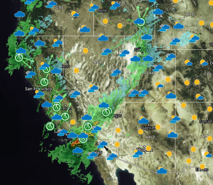
It’s not done yet, and it could shift — the chance for thunderstorms in Los Angeles is 72% on Tuesday, but only 15% on Wednesday.
And after rains let up, the biggest question remains: Will the moisture reach the Upper Colorado River Basin? That’s the drainage area that feeds the Colorado River, extending from central Utah to the Continental Divide in Colorado. The moisture is currently tracking toward the upper Green River basin, the northern tip in the map shown below:

Rainfall in the city or snowmelt from Mt. Charleston is a drop in the bucket compared to water stored in the snowpack in the vast basin. That “snow water equivalent” (SWE) is monitored closely, but it’s never more important than on April 1 each year. That’s the typical date when snowpack reaches its peak, according to hydrologists.
Currently, total SWE levels for the Upper Colorado River Basin are at 92% of normal — an improvement over recent weeks. The level was 93% on Jan. 18, and dipped as low as 85% since then, according to information from the U.S. Bureau of Reclamation.
This year’s atmospheric rivers might not produce the same results as last year’s. Forecasts in the central Rockies call for snow on Wednesday and Saturday, and again on Valentine’s Day.
Lake Mead, Lake Powell
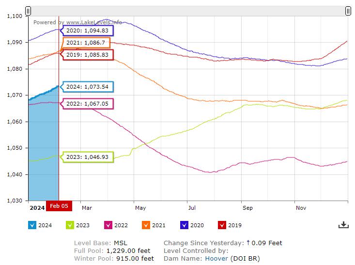
Lake Mead continues to rise, hitting 1,073.54 feet above sea level today. The trend follows the pattern of previous years (2019 and 2020), but the lake is expected to begin dropping starting in March, according to Reclamation projections. Lake Mead is projected to go from its current level to 1,044.33 feet by December 2025 — a drop of about 29 feet.
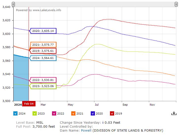
Lake Powell has been dropping steadily, but the government plans to keep more water there as spring runoffs begin. Projections indicate Reclamation will raise Lake Powell by about 10 feet from its current level by the end of 2025. The lake’s surface is currently at 3,564.61 feet above sea level.
And if spring runoff doesn’t cooperate, the federal government has been working with tribal governments and state agencies to secure agreements to conserve water — which will be stored in Lake Mead.
Those conservation agreements get a boost when there’s rain in Southern California. Lower demand for river water helps the whole system.
For the latest news, weather, sports, and streaming video, head to KLAS.

