What are the ‘atmospheric rivers’ that keep flooding California?

Millions of California residents are currently under flood watches and severe storm warnings as more unprecedented amounts of rain are expected to hit, per NBC News.
The record-breaking rains have hit San Diego and Ventura county within the past month, forcing residents to evacuate, according to Reuters.
The phenomena fueling these storm surges is a mix of atmospheric rivers, El Niño and the the “Pineapple Express.”
What are atmospheric rivers?
The National Oceanic and Atmospheric Administration, or NOAA, describes atmospheric rivers as long, narrow areas in Earth’s atmosphere that carry water vapor from the tropical equator to other parts in the world.
Known for their uncanny resemblance to rivers, atmospheric rivers are essential in bringing water to areas near the poles and away from the equator, per the Department of Energy.
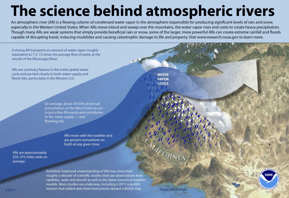
A graphic provided by the NOAA gives a simple example of what an atmospheric river looks like from above and how it normally hits California, a common location for it.
Did El Niño influence these atmospheric river storms?
El Niño is a weather event when the Pacific Ocean surface is warmer than normal, especially in the Eastern and Tropical zones, according to the U.S. Geological Survey.
Many weather forecasters rely on El Niño (or its counterpart, La Niña, where it’s dry weather) to predict the weather, according to extreme weather expert Katerina Gonzales in an interview with Scientific American.
Gonzales said that this year California weather reporters were predicting a dry winter because the past two winters had been overall dry and it’s currently the third year of La Niña, per Scientific American.
According to Reuters, the two atmospheric river storms hitting California this week occurred because of warm ocean water around the Hawaiian islands, also known as a “Pineapple Express.”
What’s a ‘Pineapple Express’ storm?
One of the strongest atmospheric river storms is known as the “Pineapple Express,” where moisture from Hawaii travels to the western United States with a ferocity to cause extreme rainfall, floods, mudslides and other serious damage, according to the NOAA.
The “Pineapple Express” hitting California this week is expected to have two storm systems, both originating from Hawaii, with forecasters expecting them to increase in intensity throughout the week.
The New York Times reports that there have already been landslides in western Washington state due to the storms, while predicting that the second storm in the “Pineapple Express” could be worse this coming Sunday. The first storm is expected to hit Wednesday.
San Francisco is expected to have high winds, heavy rains and possible flooding starting on Wednesday, according to NBC News, with snow up to 20 inches in the mountains that can cause almost “impossible” travel conditions.
Climate scientist and meteorologist Daniel Swain from the University of California says there is a chance for flooding in Southern California on Thursday, but Northern California can expect heavy rains lasting 6 to 12 hours, per Reuters.

