Austin's summer weather: May was hottest ever. June was hottest ever. July: Hold my beer.
We're only halfway through the year, but 2022 already is becoming a benchmark in Austin weather history, marked by record levels of extreme heat and increasingly parched soils.
Drought conditions have worsened to the point that the Lower Colorado River Authority announced Saturday that it was cutting off releases of water from the Highland Lakes to its agricultural customers in Colorado, Wharton and Matagorda counties for the year's second growing season, typically from August to mid-October, under requirements in the state-approved Water Management Plan.
“The majority of the Hill Country has only received between 5 and 10 inches of rain since October, well below average, and the amount of water flowing into the Highland Lakes from January through June is the lowest on record for that six-month period,” said John Hofmann, who oversees the LCRA's water operations.
The Water Management Plan requires the LCRA, which manages the water supply reservoirs in the Highland Lakes, to give priority to supplying cities, businesses and industries with water. Still, the LCRA is asking municipalities and industries to voluntarily reduce their water use by 5%.
"LCRA curtailed the amount of water from the lakes available during the second growing season in 2018 and cut off water from the lakes for interruptible customers in 2012 through 2015," the agency said in a statement.
For weather watchers in Central Texas, 2022 has already been a source of anxiety after:
A January that went 27 days without rain.
A brief freeze in February that triggered memories of the statewide disaster the previous year and put the region on edge.
As many as five tornadoes tore through Central Texas on March 21, leaving trails of damage across multiple counties.
A spring with only 4.7 inches of rain in a season that normally produces about 10.3 inches.
A May and a June that were each Austin's hottest on record.
And it's only July.
To understand what's going on this year, let's unpack some more statistics for Austin, as recorded by the National Weather Service.
Drought weather: Why a hurricane coming to Texas might be our best hope to curb Austin's drought
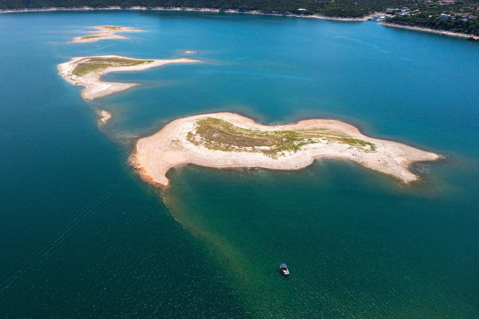
57% full: Portion of Lake Travis considered full by the LCRA, which manages the lake for flood control and hydroelectricity.
The water elevation at Lake Travis, which is both an aquatic playground and a critical water reservoir for the Austin area, was at 650.2 feet above mean sea level — about 17 feet below the historical average for July.
67.6 degrees: Average temperature for the first half of 2022, January to June, at Camp Mabry, site of Austin's main weather station.
That average includes some notable temperature readings by themselves:
April's average temperature of 73.7 degrees made it Austin's sixth-warmest on record.
May was Austin's hottest ever, with an average temperature of 82.3.
June also was Austin's hottest ever, with an average temperature of 87.7.
When we compare 2022's six-month average to three of Austin's hottest years, we find that this year is still trailing 2020's average of 68.6 degrees, 2011's 68.8 and 2017's 70.3 degrees. But 2022 is definitely in the running.
Lake safety: 'Drowning is preventable': Authorities urge safety on Central Texas rivers, lakes this summer
100.4 degrees: Average maximum temperature in June.
That's the highest such reading for June and the first time it's been in triple digits, according to the weather service. It's also what happens when two-thirds of the month's daytime highs are 100 degrees or warmer. Austin logged 21 days of triple-digit temperatures in June, eclipsing the previous record of 20 days for the month, set in 2008.
As a side note, the average maximum temperature in May was 94.3 degrees, also an all-time record for the month.
Heat safety: Use hydration, common sense to protect yourself from Central Texas heat
2.28 inches: Total rainfall in June at Camp Mabry.
Even though the month normally produces only about 3.68 inches, June was exceptionally dry with 28 rain-free days. About 0.6 of an inch of rain was recorded June 4 and about 1.68 inches fell June 27.
12.13 inches: Total cumulative rainfall for 2022, January to June.
Austin's normal cumulative rainfall by July 3 is about 18.8 inches, which is more than 6 inches higher. Rain is absent from the weather service's extended seven-day forecast, so the deficit is sure to worsen in July.
June heat: Austin breaks June record for 100-degree days — and 5 other things to know about the weather
89.7 degrees: Highest average temperature for July in Austin, a record set in 2011.
Here are some other July statistics that we need to remember, in case they get superseded this year:
The driest July in the past 20 years was in 2015, when we got only a trace of rain.
Six of Austin's 10 warmest Julys were in the past 20 years, as the effects of climate change have become more apparent.
The average temperatures in the five hottest Julys were 88 in 2016, 88.9 in 2017 and 2020, 89.5 in 2009, and 89.7 in 2011.
July 2011 shares the record with August 2011 for the month with the most 100-degree days — 29.
On Saturday, Austin recorded its 23rd day of triple-digit temperatures for the year and the first one for July. If the current forecast holds, we will be facing at least another week's worth of 100-degree weather. The forecast highs for Independence Day, Tuesday and Wednesday are all 101, Thursday and Friday are 102, and Saturday is 103.
Wildfire dangers: 'A bad year coming': Experts warn of high chance for significant wildfire season in Austin area
52% chance: The likelihood that La Niña will continue from July to September.
We really can't talk about our unseasonably warm and dry conditions without understanding La Niña, which is the cooling of sea temperatures in the tropical waters of the eastern Pacific.
Its effect on the jet stream in the Northern Hemisphere — keeping storm-making colder air penned up north, for instance — typically leads to warmer and drier conditions in Texas. An usually persistent La Niña — one that has been in effect since the end of last year — continues to hold Central Texas hostage to extreme heat and drought.
A sliver of hope for relief can be gleaned from a June forecast by the National Weather Service's Climate Prediction Center, which found that "uncertainty remains over whether La Niña may transition to (neutral) during the summer."
Earlier this year, the climate center put the chances of La Niña for June through August at around 65%, but it said in its most recent forecast that "the odds for La Niña decrease into the Northern Hemisphere late summer (52% chance in July-September 2022)" before increasing in the fall and winter.
This article originally appeared on Austin American-Statesman: Half of Austin's weather year: Records set, what they mean for summer

