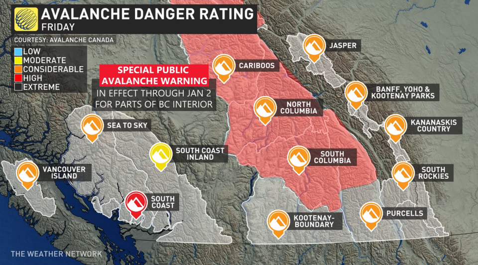
High avalanche danger for B.C. South Coast, warnings span Interior
Recent storms combined with mild weather in British Columbia have set the stage for potentially dangerous conditions.
Another system is set to bring wet light snow to higher elevations. When you take into account the precipitation and the warmer temperatures, there is serious concern for avalanches in higher elevations.
Avalanche Canada has issued a special public avalanche warning (SPAW), which is in place until Jan. 2, for most of B.C.'s Columbia Mountains, Glacier and Mount Revelstoke national parks, as well as the Northern Rockies.
The SPAW extends from the southern boundaries of the Purcell Wilderness Conservancy, and Kokanee Glacier and Valhalla provincial parks to Williston Lake, north of Pine Pass and Mackenzie.
“A prolonged cold and dry start to the winter created a number of persistent weak layers in the snowpack across the interior ranges of B.C.,” states Avalanche Canada. “The recent storm and warming temperatures have now destabilized that weak snowpack, making large, human-triggered avalanches likely.”
Recent storm cycles for Western Canada over the past weekend added significant snow on top of an exceptionally weak, lower snowpack. This has brought the conditions to a tipping point where dangerous avalanches are likely, states Avalanche Canada.
While avalanche danger ratings may start to decrease as the weather improves, the risk will still be there.
There are ways to help manage threats, including making conservative terrain choices such as sticking to lower-angle slopes.

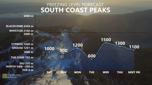
For B.C.’s South Coast, rain is forecast for the weekend. Through Saturday morning, the Lower Mainland may see 20-40 mm of rain while 10-20 mm is possible for the Victoria region.
WATCH: Treacherous travel throughout Vancouver as freezing rain hits streets
Check The Weather Network for the latest updates in British Columbia.

