B.C. to endure major pattern change as atmospheric river arrives
Big changes tend to happen all at once these days, and there’s no shortage of drama in the atmosphere above Western Canada as we look toward the end of September.
A pattern change is on the way for British Columbia that’ll bring an extended period of wet weather for coastal sections of the province.
Multiple bouts of rain are possible in the days ahead, offering much-needed relief for an area that’s endured a high-impact drought for much of the summer.
DON'T MISS: Wildfire season not over yet: Some B.C. blazes might burn into winter
A lurch from dry to wet
Even though summertime is usually B.C.’s driest season of the year, the province has been unusually parched this year.
Vancouver typically picks up about 60 mm of rain during an average September. The city’s only seen 9.8 mm of rain so far this month.

The extreme dryness has been so bad this year that we’ve seen record wildfire activity throughout the province, some of which may only be quenched by cold, snowy conditions this winter.
This exceptional stretch of below-average precipitation will soon come to an end for the South Coast—but unfortunately, folks across the B.C. Interior will largely miss out on the truly beneficial rains heading for the province over the next week.
Major pattern change ahead
A dip in the jet stream arriving this weekend will herald the start of this wet pattern encroaching on the West Coast through the end of September.
Once this trough arrives, we’ll see an extended period of unsettled weather across much of B.C. as a series of systems tracks across the region from Sunday through the workweek.
An atmospheric river streaming in from the Pacific will give these systems plenty of moisture to work with.
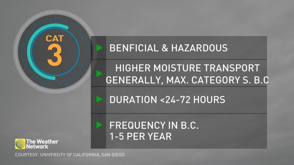
This impending slug of moisture will rank as a Category 3 on the University of California San Diego’s atmospheric river scale, which ranks the duration and magnitude of these plumes of moisture as they stream into the West Coast.
RELATED: Canada will introduce a new impact scale for atmospheric rivers
Category 3 atmospheric rivers are both beneficial and hazardous, bringing quenching rains that could also lead to localized flooding if it falls too quickly.
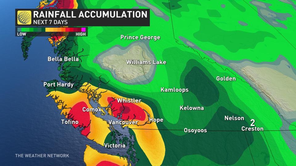
We’re certainly going to see plenty of rain over coastal sections of B.C. through the next week, with 50-100 mm falling across the Lower Mainland and up to 200 mm throughout higher elevations.
Another sign of autumn creeping ever closer is falling freezing levels. We could see accumulating snow at elevations above 2000 m over the next week.
Stay with The Weather Network for all the latest on conditions across B.C.

