Back-to-back winter storms spark weather advisories and warnings in Tahoe region
Back-to-back winter storms are headed for Northern California this weekend — bringing heavy rainfall, mountain snow, and possible thunderstorms and flooding.
The good news is meteorologists say gloomy weather won’t produce conditions as extreme as the Feb. 4 storm that killed three people and cut power to thousands.
The bad news is the looming conditions may be harsh enough to keep you indoors — and away from Tahoe — during President’s Day weekend.
A winter weather advisory is in effect from 10 a.m. Saturday to 4 a.m. Sunday for parts of the Sierra Nevada, including the greater Lake Tahoe area. A winter storm warning goes into effect shortly after, from 4 p.m. Sunday to 10 a.m. Wednesday for the same areas.
The National Weather Service also issued a flood watch, in effect from Sunday afternoon to Wednesday morning, for various portions of Northern California including the Sacramento Valley, the Delta, Northern San Joaquin Valley and the foothills.
Here’s what to expect.
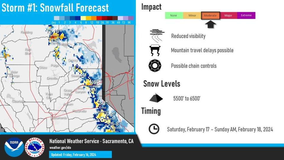
First storm to hit Northern California
The first storm, which will pass over the region between Saturday and Sunday, will drop moderate rainfall across the Valley and foothills and snow in the mountains.
Today will be a quiet weather day with more active weather expected over the weekend and through mid next week. Here's a breakdown of the anticipated weather impacts with these two storms. #CAwx
Forecast: https://t.co/WjKBsJmSfA
Roads: https://t.co/6jnhwJwK5a pic.twitter.com/U46vVdhIKt— NWS Sacramento (@NWSSacramento) February 16, 2024
Meteorologist Dakari Anderson with the weather service said the first storm isn’t expected to produce extreme conditions.
Storm No. 2 to hit Northern California
The second storm will be more aggressive.
According to the weather service, the second system will kick off late Sunday evening through at least Wednesday.
Elevations above 5,500 feet are forecast at 1 to 2 feet of snow starting Sunday through Wednesday; above 7,000 feet is forecast at 3 to 4 feet.
The brunt of the storm will occur on Monday, with the heaviest amounts of rain and snow expected across the area.
Anderson said an additional 1.5 to 2 inches of rain could fall across the Sacramento region.
Another 2 to 3 inches are expected in the foothills, including portions of Redding. The lowest amounts — up to 1.5 inches — are forecast for the northern San Joaquin Valley.
Wind gusts are forecast to whip between 20 and 30 mph on Saturday throughout the Valley, with speeds increasing on Monday.
Anderson said gusts as high as 55 mph are expected across the mountains.
How much snow has fallen at Tahoe ski resorts?
The UC Berkeley Snow Lab, located at Donner Pass, received another 13 inches of snow during the last storm from Wednesday into Thursday morning.
“We are now at 85% of median snowfall and 83% of median snow water equivalent to date,” the laboratory posted Thursday on x, formally known as Twitter.
We have received 13" (33 cm) of #snow in the last 24 hours, which brings our storm total to 14.2" (36 cm) so far. We are expecting snow showers today.
We are now at 85% of median snowfall and 83% of median snow water equivalent to date. More on the way!#CAwx #CAwater pic.twitter.com/wfoaKvRUyt— UC Berkeley Central Sierra Snow Lab (@UCB_CSSL) February 15, 2024
Here’s how much snow has fallen in Tahoe so far this season across ski resorts, as of Friday, according to their websites:
Sugar Bowl Ski Resort: 179 to 231 inches
Palisades Tahoe: 195 inches
Mt. Rose Ski Tahoe: 141 to 191 inches
What do you want to know about life in Sacramento? Ask our service journalism team your top-of-mind questions in the module below or email servicejournalists@sacbee.com.

