Bahamas prepares for Tropical Storm Isaias as disturbance heads south of Puerto Rico
Potential Tropical Cyclone Nine, a broad and fast-moving storm, is expected to sweep Puerto Rico with 45 mph winds and several inches of rain overnight as it passes south of the island.
Next in its sights could be the Dominican Republic and Haiti on the island of Hispaniola, which is already waterlogged from repeated rain over the last few weeks. Emergency managers worry any extra rain could set off devastating mudslides and flooding.
Current projections from the National Hurricane Center, which has yet to upgrade the disturbance to Tropical Storm Isaias, show it could make its way toward the Bahamas and South Florida by the weekend, although it’s still too early to predict exactly what kind of impact it would have.
The 8 p.m. Wednesday update continued to show the storm’s track potentially going up the spine of Florida by the weekend as a possible tropical storm with 50 mph winds and rain. The storm’s track had shifted east, according to an update earlier in the day.
The National Weather Service said Wednesday South Florida could see one to three inches of rain and rough seas, although it stressed in bold and bright red letters that this prediction could be subject to “major changes.”
Forecasters are uncertain about Isaias’ future path and strength. It’s a wide and sloppy storm that has been slow to form a center, which makes it hard for forecasters to track.
“It still must be stressed that since the system lacks a well-defined center and remains in its formative stage, uncertainty in the specifics of the track forecast remains high in both the short and longer range,” forecasters wrote.
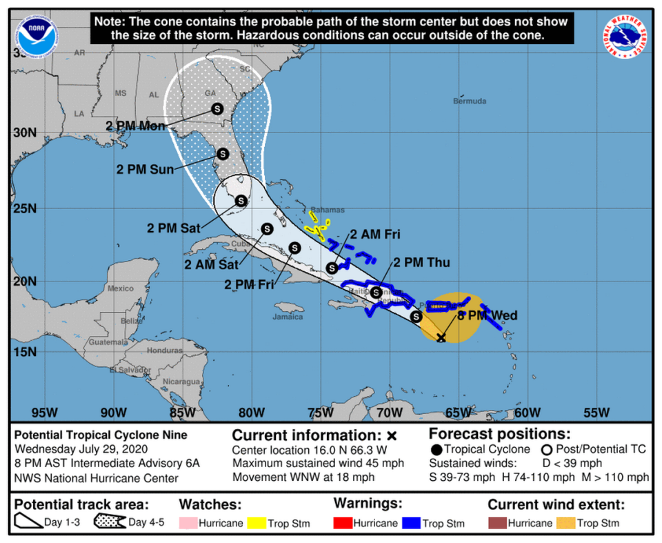
Current projections show Isaias crossing over Hispaniola on Thursday, a dangerous possibility for the island but a good sign for the Bahamas and Florida.
The high mountains of Hispaniola are known as hurricane shredders, and if a weaker Isaias emerges on the other end of the island, current models show it would be met with high wind shear in the Florida Straits, another factor that slows down storms.
Over the last day, the NHC has downgraded the expected wind speed of the disturbance, which is expected to strengthen into a tropical storm sometime Wednesday night. Barbuda, Antigua, Martinique, Guadeloupe Montserrat, St. Kitts and Nevis discontinued their tropical storm warnings Wednesday.
Wednesday morning, the Bahamas issued tropical storm warnings for the southeast Bahamas and Turks and Caicos Islands and a tropical storm watch for the central Bahamas. Turks and Caicos announced it planned to close all its airports as of 9pm Wednesday.
Caribbean countries watching, preparing for tropical storm amid COVID-19 outbreak
Bahamian officials urged residents to finish their hurricane preparations in anticipation of the arrival of Tropical Storm Isaias.
“Start to prepare now,” Lillian Quant-Forbes, the director of social services, said during a morning press conference. “If it goes away, then all is good and we thank God for it. But prepare as if it is coming.”
While the storm’s track shifted slightly overnight to where the Bahamas was not in the cone, the country’s chief meteorologist, Trevor Basden, warned Bahamians not to drop their guard.
Tropical storm-force winds, he said, were likely in the next 48 hours for the southeastern Bahamas and the nearby Turks and Caicos Islands.
“With this system, it is a rainmaker,” said Basden, the director of the Bahamas Department of Meteorology. “As it passes toward us in a west-northwesterly direction, you can expect localized flooding; so you’re looking at rainfall amounts one to three inches with some accumulations of pockets, six to eight inches.”
Given the low-lying areas of the country, Basden noted that one to three inches of rain in a couple of hours could lead to flooding.
“The blessing we have here is that it’s expected to move rapidly and also we have another blessing in that it is to go over the mountainous areas of Hispaniola, that’s the Dominican Republic and Haiti, and then the next big brother to block, is also Cuba. No matter what, let’s call it a rainfall event so be prepared,” he said.
Still, given the devastating effects of last year’s Category 5 Hurricane Dorian, many Bahamians remain uneasy and are concerned that what’s being predicted to be a tropical storm, could turn into a full-force hurricane.
NOAA calls for a busy 2020 hurricane season, with the possibility of ‘extreme activity’
Basden, noting that Dorian was out in the warm ocean, said it was highly unlikely Isaias would follow a similar trajectory. Still, he acknowledged that while the models are very good when it comes to track forecasting, they still fall short on intensification.
“But noting what happened with Dorian, the scientists tweaked the models,” he said. “For the most part, we are looking at a 75 percent probability that this would not develop into even a hurricane.”
Nevertheless, the head of the National Emergency Management Agency, Capt. Stephen Russell, told Bahamians that as a result of the potential rain and flooding, floodwater rescue and emergency teams were being activated and the country’s 115 shelters were being prepared, with a 9 a.m. Thursday deadline for all shelters in the southeastern Bahamas.
While emergency managers don’t envision a scenario where they will have to relocate people from one island to the next, Russell said that individuals living in low-lying areas that are prone to flooding should be prepared to move in a timely manner when advised to do so.
“You should know where your shelters are. If you are not comfortable in your home, make plans now to move and let somebody know where you are going if necessary,” Russell said.
Bahamians, he said, should continue to monitor the system very closely and “aim to complete your hurricane preparedness activities now as you get more into the active period of the 2020 hurricane season.”
Also still under tropical storm warnings are Puerto Rico, Vieques, Culebra, the U.S. Virgin Islands, the British Virgin Islands, St. Martin, Saba, St. Eustatius, St. Maarten, Anguilla, St. Barthelemy, Dominica, and the Dominican Republic.
The storm could bring 50 to 60 mph winds, heavy rains and potentially life-threatening flash flooding and mudslides to the northern Leeward Islands, the Virgin Islands and Puerto Rico. The Leeward Islands, British and U.S. Virgin Islands could see three to six inches of rain.
Puerto Rico could see three to six inches of rain, with some areas seeing up to 10 inches of rain. The Dominican Republic, northern Haiti and the Turks and Caicos could experience three to six inches of rain, with some spots seeing up to eight inches of rain.

