Battle against still-growing Fairview Fire continues amid storm, potential floods
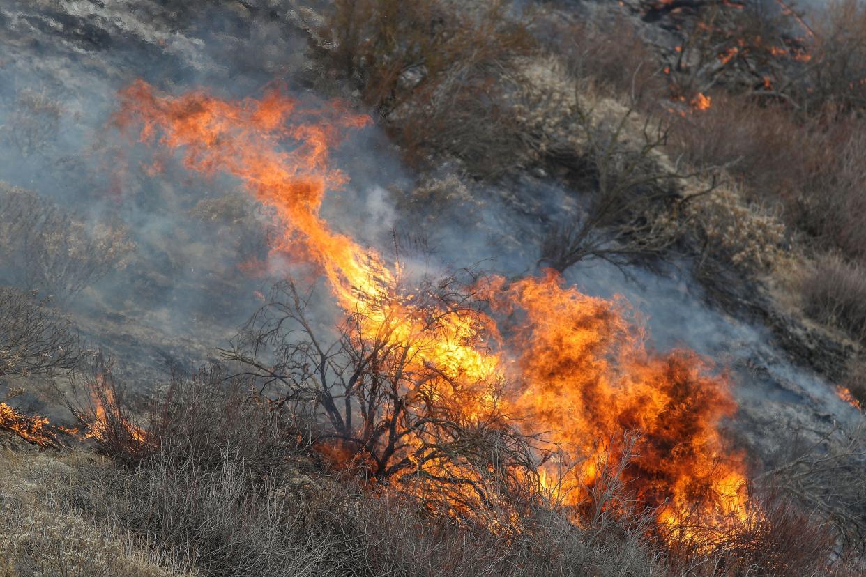
The hundreds of firefighters battling the Fairview Fire burning on the west side of the San Jacinto Mountains heading into the weekend faced a new factor and challenge: a storm that was anticipated to bring heavy rain and winds along with lightning and, potentially, flooding.
Riverside County officials warned Friday that the incoming storm, which was fueled by the remnants of a tropical storm that has made landfall in Mexico, could bring up to 8 inches of rain to parts of Riverside County and lead to flash flooding and potential mud and debris flows.
However, the fire area was more likely see one to three inches, though that rain could still create a risk of flooding in areas that have already burned. A Cal Fire spokesperson said "a pretty good rain" was falling on the fire as of the afternoon. However, he said it was too early to know how that will affect firefighting efforts.
The National Weather Service issued flood watches through Riverside County from Friday morning through Saturday night. The heaviest rain was expected on the eastern slopes of the mountains and in their neighboring deserts. In addition, high wind warnings are in effect for all of the fire area.
A warning covering the San Jacinto Mountains called for winds of 45 to 55 mph and gusts of as much of 100 mph. Another warning said winds could be 35 to 45 mph, with gusts of up to 65 mph, in valley areas west of the mountains, including Temecula, Sage and Cahuilla.
The combination of winds, potentially heavy moisture and resulting floods was likely to create a complicated situation for fire crews and one that impacts their ability to fight the fire could vary widely depending on how the storm unfolds.
Cal Fire Capt. Richard Cordova said Friday morning that the winds were already picking up and firefighters were prepared to see gusts of as high as 50 to 60 mph. He said those winds, which would come before any moisture, would likely build the fire and make it blow in different directions near Sage and Temecula on the south and southwest sides of the fire. Those winds could also carry embers, which could start new fires.
Cordova said any moisture the weather brought would help firefighting efforts, while a worst-case scenario would be for the storm to bring wind while all the moisture stays to the east. However, lightning and too much rain that results in flooding could also create challenges.
"It kind of goes good to bad to good again, especially with this type of system which we don't normally deal with, which is the remnants of a hurricane," he said.
Challenges Friday
A Friday morning update from CalFire stated that ERC, a burn index calculation firefighters use to determine likely conditions, was expected to decrease rapidly from current levels in the 90th percentile. That would be a good thing for efforts, Cordova said.
Evacuation orders in some parts of the Sage and Temecula areas were reduced to warnings around 5:30 p.m., Friday amid rainy weather conditions that CalFire said in a Tweet were aiding firefighters to slow the spread of the fire.
The agency said Thursday that it expected full containment of the fire by Sept. 12, although officials cautioned that is subject to changing conditions. Cordova said Friday the agency was still shooting for that day, but changes could make meeting that target impossible.
As of just before 3 p.m. Friday, Cal Fire had mapped the fire, which started southeast of Hemet Monday afternoon, at 27,463 acres. That acreage was up just slightly from 27,319 acres Thursday night. Containment has remained stalled at 5% since Tuesday.
Several more areas received evacuation orders Thursday, and they extended south and east from Hemet to Lake Riverside, Aguanga and Valle De Los Caballos and near Thomas Mountain. Valle De Los Caballos is just a couple of miles from Temecula. A much smaller area on the north side of the evacuation area between Hemet and Mountain Center along Highway 74 was under evacuation warning.
Cordova said Thursday was "a better day" for firefighting efforts with the fire growing more modestly than it had previously.
"We had a cloud cover over the incident, and it that gave firefighters an opportunity to get into some areas where we weren't able to get in before," he said. Friday and Saturday, however, looked to be very challenging because of the winds, he said.
During an operational briefing posted to YouTube at around 11 a.m. Friday, a Cal Fire official said one of the most challenging sections of the fire going into Friday afternoon was expected to be on the southwest edge, where fire was moving off of Red Mountain to the roads below around Sage. Day Operations Branch Chief Justin McGough said that Thursday night the fire began impacting homes in that area, which he said had been under evacuation order for three days.
He added that residents called 911 as the fire approached and the department had to stop firefighting operations to help remove the residents.
"We again had to put our firefighters in harm's way to remove people that had chosen to stay home in an area that had been under an evacuation order..." he said. "We want (residents) out of harm's way so that we don't have to continue to put our firefighters in increased harm's way to go in and get (them) out."
In that area, fire teams were trying to "hold onto the ground we've got" amid winds that were pushing the fire further south and west Friday. McGough added that residents of Anza and nearby communities could also expect to see an increased firefighter presence in their area as firefighters work to get ahead of movement into their communities and establish control lines there.
Winds could push fire into Hemet
There was also concern Friday about the northwest side of the fire around Hemet, where high winds could lift sparks and other fire material and deposit it into a "receptive fuel bed that bumps up to and is part of the city of Hemet."
On the eastern side, meanwhile, there were concerns about what heavy moisture could do to firefighting efforts. McGough said that firefighters are continuing to work to establish fire control lines on Rouse Ridge and using some large machinery to do so. However, the department will need to make sure firefighters working in those areas don't become stranded because of flooding.
"We need make sure those (firefighters) don't become part of the problem, because we have heavy rainfall and they are unable to negotiate the existing road system to get out of harm's way into a safety zone," he said.
Based on the anticipated movement of the fire to the south, it was likely there would be more evacuations closer to Temecula on Friday. As of Friday afternoon, Anza Road was the southern boundary of the evacuation area.
Cordova said Friday morning it was possible that the fire could eventually move into Temecula itself, with the biggest concern being that embers cast into the city could start new fires a mile or two ahead of the main fire.
"Worst-case scenario, it could hit Temecula, but we are hoping we can kind of capture it or slow it down before it gets there," he said.
Going into Friday, several aircraft, including 16 helicopters, were being used in firefighting efforts. But once winds go above 30 mph, it becomes unsafe to fly and dropping water and retardant on fires becomes ineffective, which meant there was potential for those efforts could be stopped during periods of both high wind and lightning Friday.
Damage and fatalities
As the fire has progressed, officials have expressed uncertainty about whether structures have been lost. However, Cal Fire's incident dashboard was updated Thursday to reflect that 11 structures were destroyed while three others have been damaged.
Cordova said those updated numbers are the result of inspections by the department's inspection team, which was continuing to look for more damage. He said the damaged structures are mainly in the Avery Canyon and Gibbel Road areas southeast of Hemet not far from where the fire started. 18,573 structures are currently threatened.
There have been no more injuries or deaths in the fire since Monday, when two people who are believed to have been family members trying to escape the fire died in their car. A third person, who was also believed to be a family member, sustained serious injuries outside the car.
The Riverside Sheriff's Office said Wednesday that the two people who died could not be immediately identified because of the state of their bodies.
However, NBC Los Angeles reported that a man who is related to the victims said they are a father and daughter who were killed as they tried to escape a fast-moving brush fire that raced through a canyon this week. The person who was injured is the wife and mother of the victims, who remained hospitalized with critical injuries.
Officials have not said more about the cause of the fire since saying it is under investigation. In a document filed with the California Public Utilities Commission, Southern California Edison reported “circuit activity” in the area close to the time the fire erupted.
Paul Albani-Burgio covers breaking news and the City of Palm Springs. Follow him on Twitter at @albaniburgiop and via email at paul.albani-burgio@desertsun.com.
This article originally appeared on Palm Springs Desert Sun: Fairview Fire fight continues; storm, wind, floods expected

