Bay Area storm updates: Shower and storm chances continue Tuesday

SAN FRANCISCO (KRON) — Following a stormy weekend across the Bay Area, rain is expected to persist Monday. Thunderstorms with wind gusts up to 58 mph are possible in parts of the East Bay and North Bay, according to the National Weather Service.
Rains Monday are expected to stretch into Tuesday with scattered showers continuing through Wednesday, according to KRON4 Meteorologist Kyla Grogan.
San Francisco Bay Area weather radar
“Scattered showers continue to roll through the Bay Area as we head through the holiday weekend,” Grogan said. “Our biggest concern right now is a combination of saturated ground and wind that can bring down trees and has the potential to cause power outages.”
Along with rain, high winds are expected Monday into Tuesday.
“We are under a wind advisory through 4 a.m. Tuesday morning,” added Grogan. “After that the wind will give us a break. Unfortunately, the dangers don’t end when the wind does as we still have more showers expected Tuesday into Wednesday morning. And after that we will still have the issue of some of our rivers, creeks and streams continuing to take on rain runoff which will cause levels to rise.”
This current round of rain is expected to last through Wednesday, followed by a couple of dry days, before more rain arrives next weekend.
“Our Bay Area-wide flood watch continues until 10 a.m. Wednesday,” said Grogan. “After that we should see some improvement and we get a decent break on Thursday before more showers are forecast to arrive later Friday into Saturday.”
Latest Bay Area storm updates:
Tuesday, Feb. 20
12:40 a.m. — Sonoma County park closures
The Sonoma County Regional Parks announce temporary park closes due to the storm:
Forestville River Access
Guerneville River Park
Hood Mountain Regional Park and Open Space Preserve
Riverfront Regional Park
Spring Lake Regional Park
Steelhead Beach Regional Park
Stillwater Cove Regional Park
Sunset Beach River Park
Wohler Bridge Fishing Access
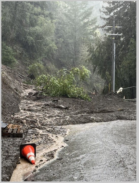
10:28 a.m. — Highway 9 closure
Highway 9 is closed between Sanborn Road and Redwood Gulch due to a mudslide, the City of Saratoga announced on X.
9:38 a.m. — Shower and storm chances continue
Shower and storm chances continue for Tuesday, according to the National Weather Service.
We're not done yet.
Shower and storm chances continue today.#CAwx https://t.co/ScrUH5FqHT— NWS Bay Area 🌉 (@NWSBayArea) February 20, 2024
8:50 a.m. — 2 high schools in west Sonoma County closed due to storm-related impacts
Two high schools in west Sonoma County are closed Tuesday due to storm-related impacts, according to the county’s Office of Education. Analy High School and Laguna High School in the West Sonoma County Union High School District are closed as well as the district’s office and all special education consortium classes after a tree fell on a building at Analy High, county officials said.
No other school closures have been reported in the county for Tuesday.
Copyright © 2024 Bay City News, Inc.
7:50 a.m. — Road closures
Here are the following road closures:
Highway 12 from Fremont Road to Watmaugh Road in Sonoma County
Highway 121 North Highway 116 Arnold Dive to 8th Street in Sonoma County
Highway 84 between Old Canyon Road to Main Street in Sunsol in Alameda County
Highway 9 from Sanborn Road to Redwood Gulch Road in Santa Clara County
7:31 a.m. — Flood Warning for Sonoma County
Due to excessive rainfall, flooding is expected in Sonoma County:
Mark West Circle near Mirable Heights
Green Valley Circle at Martinelli
Colgan Circle near Sebastopol
Small streams in surrounding areas
7:15 a.m. — National Weather Service
Scattered showers and storms are forecasted for Tuesday, according to the National Weather Service. The Bay Area has the highest chance of showers and storms Tuesday afternoon. On Tuesday evening, the Central Coast is forecasted to have the most rainfall.
Thunderstorm hazards include lightning, small hail, and gusty winds.
The NWS warns that the heavy rainfall could cause localized floods on roadways.
Monday, Feb. 19
10:15 p.m. — I-280 reopens
California Highway Patrol announced southbound I-280 has fully reopened. The highway had been closed in Burlingame due to a fallen tree.
10:05 p.m. — More than 500 flights delayed at SFO
The weather is the likely source for hundreds of flights being delayed at SFO Sunday. The delays have left frustrated travelers waiting hours for their flights. KRON4’s Sara Stinson reports.
10 p.m. — Bay Area roads closed due to weather
As of 10 p.m. Monday night, the following highways are closed due to storm-related reasons:
State Route 12 from Fremont Rd. to Watmaugh Rd. (flooding).
State Route 121 just north of State Route 116 Arnold Dr. to Eight St. (flooding).
State Route 84 between Old Canyon Rd to Main St. in Sunol (road slip-out).
State Route 9 (SR-9) from Sanborn Rd. to Redwood Gulch Rd. (mudslide debris).
9:40 p.m. — More than 9,000 PG&E customers without power in Santa Rosa
A power outage in Santa Rosa is affecting more than 9,000 PG&E customers. The outage was reported to PG&E at 9:21 p.m., according to PG&E’s outage map.
PG&E believes the outage was caused by weather. There is no estimated time for power to be restored.

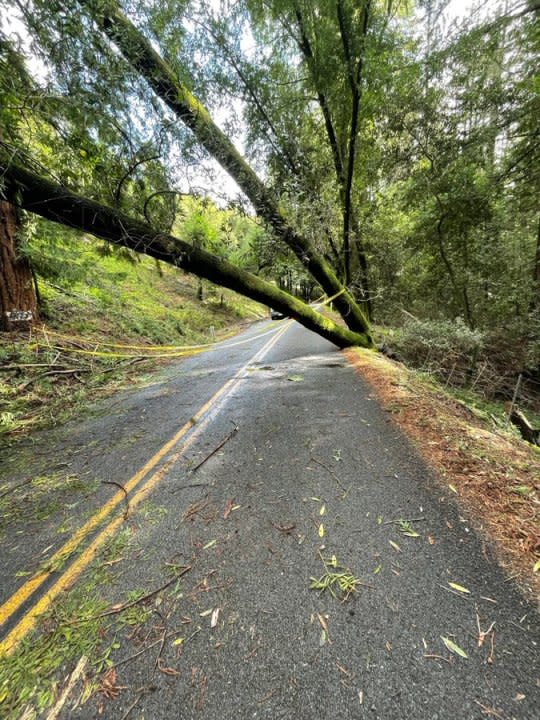
8:25 p.m. — Pinehurst Road cleared
Pinehurst Road between Canyon Road and Skyline Boulevard has been cleared and is open to all traffic. Trees and debris had fallen on it earlier Monday afternoon.
7:45 p.m. — Downed tree on SB I-280 in Burlingame halts traffic
A tree has fallen onto the southbound lanes of 280 right before the Trousdale drive exit in Burlingame. Crews are working to remove the tree now. Only one lane open. pic.twitter.com/5EIJlrcuRU
— Sara Stinson (@SaraStinsonNews) February 20, 2024
A tree reportedly fell on southbound lanes of I-280 at Trousdale Drive in Burlingame blocking all lanes. Avoid the area if possible. There is no estimated time of reopening.
6:20 p.m. — Flood warning in Sonoma County

The National Weather Service issued a flood warning in parts of Sonoma County effective through 8:15 p.m. Monday. Officials warn never to drive through water on roadways,
6 p.m. — Winter weather warning in the Sierra
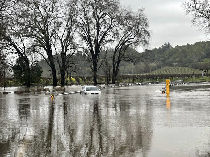
5:04 p.m. — Waters rise in Sonoma County flooding streets
Mark West Station Road at Starr Road in Sonoma County flooded Monday with water rising and actively flowing across the roadway at the 2-inch mark, Sonoma County Fire officials reported.
Current Situation:
3:50pm Monday, 2/14/24 Mark West Station Rd at Starr Rd. Water continues to rise and is actively flowing across the roadway at the 2’ mark. #sonomacounty pic.twitter.com/tg5wBd8jwY— Sonoma County Fire District (@SoCoFireDist) February 20, 2024
4:30 p.m. — Special weather statement issued

The National Weather Service issued a special weather statement for Redwood City, Mountain View and Palo Alto effective until 5 p.m. Monday. Residents should expect up to 5-mile-per-hour winds. No hail is expected. NWS advises residents to seek sturdy shelter.
4:19 p.m. — Severe thunderstorm warning in effect

The National Weather Service issued a severe thunderstorm warning in San Mateo, Redwood City and Foster City until 4:30 p.m. Monday. Residents should expect up to 60-mile-per-hour winds and possible pea-sized hail as well as a possible tornado.
3:45 p.m. — 55 mph winds reported at Land’s End in San Francisco
Can confirm sustained strong winds at Land’s End today.
NWS projects 55mph gusts!
Volume up! https://t.co/VmIGr5l2RI pic.twitter.com/E8aEGOAAzl— SAN FRANCISCO FIRE DEPARTMENT MEDIA (@SFFDPIO) February 19, 2024
3:22 p.m. — North Bay flood advisories extended
Flood advisories for Cloverdale, Santa Rosa and Napa have been extended until 10 p.m. Monday, according to the NWS.
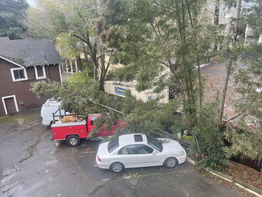
2 p.m. — Tree down in San Anselmo
A tree fell in San Anselmo Monday morning, landing on several vehicles parked nearby. It is unknown if any of the vehicles suffered significant damage.
1:55 p.m. — Pinehurst Road in Contra Costa County closed due to fallen tree
Pinehurst Road is currently closed to traffic between Canyon Road and Skyline Boulevard due to fallen trees and debris, according to Contra Costa County Public Works. Drivers are advised to use alternate routes.
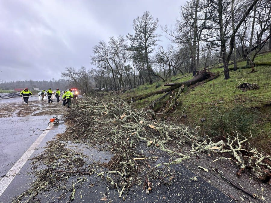
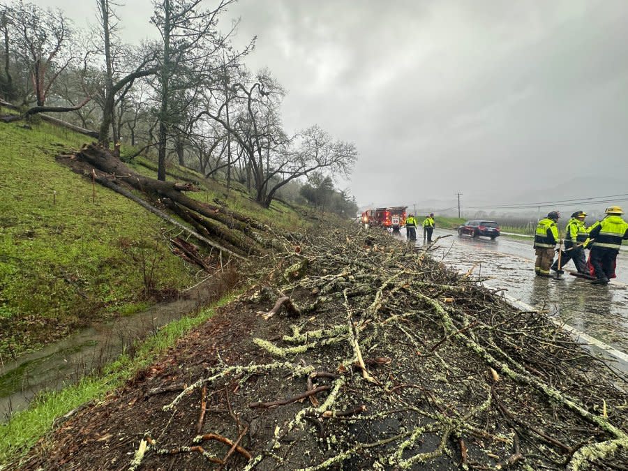
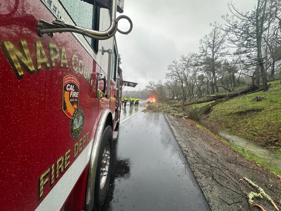
1:20 p.m. — Trees down in Lake and Napa counties
Storm impacts along with saturated soil and strong winds have led to several trees coming down in Napa and Lake counties, according to CalFire. One tree, on Highway 29 at Tucker Road, temporarily blocked southbound traffic.
1:15 p.m. — Chain control in effect over Donner Pass
Chain control is in effect on I-80 westbound from the Donner Lake Interchange to Rainbow and on I-80 eastbound from Kingvale to the Donner Lake Interchange, according to the California Highway Patrol.
Chains or traction devices are mandated on all vehicles except four-wheel/all-wheel drive vehicles with snow tires on all four wheels.

1:05 p.m. — Flood advisories issued for North Bay
Flood advisories have been issued until 4 p.m. Monday for Napa, Cloverdale and Santa Rosa. The NWS has warned of minor flooding, flooding of highways, streets and underpasses. If you encounter flooding on the roadway, the NWS advises strongly against trying to drive through it.
“Turn around, don’t drown,” the weather service tweeted.
1 p.m. — Road slipout on Highway 84 causes road closure
One-way traffic control is in effect on Highway 84 near Sunol after a slipout, Caltrans District 4 said Monday morning. The affected roadway, east of Palomares Road, will be completely closed starting at 5 p.m., according to California Highway Patrol. Caltrans will reassess the area on Tuesday. There is no estimated time for reopening the roadway after Monday night’s closure.
For the latest news, weather, sports, and streaming video, head to KRON4.

