Bears, berries, and unforgettable vistas: Hiking Glacier National Park
GLACIER NATIONAL PARK, Mont. — I'm the kind of person who takes those I-was-here photos at the entrances to national parks.
I know it's cheesy. But for me, it's an important part of the whole experience.
My husband and I had planned to add Montana's Glacier National Park (plus mandatory cheesy souvenir photo) to our parks-visited list in the summer of 2020, but we canceled because some friends wanted to join us and they couldn’t get rooms.
Turns out it was just as well. The COVID-19 pandemic meant that summer would find us hunkered down at home.
► Heading to Glacier National Park?: Top tips to make your trip unforgettable
But in hopes that the pandemic could wane, as June 2020 rolled around we threw the dice and booked rooms for the summer of 2021, figuring we could cancel if things did not improve.
That gamble paid off.
Crown of the Continent
Glacier — known as the Crown of the Continent — is located in northwestern Montana.In 1910, President William Howard Taft signed a bill establishing Glacier – known as the Crown of the Continent – as the country's 10th national park. The area previously had been the domain of the Blackfeet Indians, who controlled the prairies east of the mountains, and the Salish and Kootenai Indians who lived in the western valleys, according to the National Park Service.
Covering 1,012,837 acres, its northern boundary ends at the Canadian border, but the park flows seamlessly into that country's Waterton Lakes National Park. Together they form The Waterton-Glacier International Peace Park, a UNESCO World Heritage Site.
Our planning picked up pace as our departure neared with lots of emails as we tried to make sure we had everything covered. I borrowed a couple of guidebooks from the library and we downloaded and printed maps from the park's website. Two days before departure, we bought a pair of walkie-talkies because we thought they'd be handy if our group ever got separated.
We knew there was no way we could hit all of Glacier's 700-plus miles of hiking trails, so we made up a to-do list including a few iconic ones. Unfortunately, we had to cross off some hikes on the Canadian side, like Waterton Lakes due to the border closure.
As a practical matter, given that we are middle-aged, not natural athletes or in particularly great shape, we figured one good hike each day would be a win. The unseasonable heat – into the 90s – also forced us to temper our ambitions. Temperatures in the 90s were not in our playbook when we planned our trip.
In late June, fully vaccinated and masked up for our flight — the first in almost two years — we headed to Big Sky Country. Travel was drama-free as all the fellow passengers I could see took COVID precautions, as did most of the people I saw in the airports.
Morton and I met our friends from New York City – Lanny, Audrey, Rohan and Evelyn – in Spokane, Washington, and drove just over five hours the next day to our accommodations at Rising Sun Cabins near the park’s east side. That's not the most direct way to get to the park. You can fly into Glacier Park International Airport in Kalispell, which is much closer; but we wanted to sample Spokane. Amtrak also is an option.
The thrill of seeing the entry signs to the national parks never gets old and this time was no exception. Yes, I take cheesy photos at those signs. I consider doing so part of the total experience.
Timing our visit for the last week of June was risky, as there was the possibility of some trails not being open because of snow; but going later meant we would hit the summer crowd that would descend on the July 4 weekend.
We got lucky when the iconic Going-to-the-Sun Road opened completely the Friday before we arrived. Tickets are required to travel the historic road ($2 per vehicle and valid for seven consecutive days), but since we were staying at Rising Sun Cabins ($194 per night including fees) for the first five days of our visit, we didn’t need tickets.
Based on our past experiences with the larger national parks, we planned to spend five days on the east side and three on the west side to cut down on drive time between sites.
We entered the park at the West Glacier entrance, and traveled 44 miles along Going-to-the-Sun Road to get to our cabins. The iconic route exceeded the hype as we passed eye-catching scenes including Bird Woman Falls, Haystack Falls and the Weeping Wall. Our cabins were perfect — rustic enough for us to feel like we were truly in the great outdoors, but with enough modern amenities to make us comfy.
But armed daily with two cans of bear spray, a couple of bear bells, bug spray, sunblock, the walkie-talkies, binoculars and lots of water and snacks, we were ready for whatever adventures lay ahead.
Day 1: St. Mary Visitor Center; Two Medicine
This was our getting-to-know-Glacier-a-little day. We figured we'd just explore what was closest to us and fairly easy to hike while we built up our stamina to take on the big stuff.
We started out for the nearby St. Mary Visitor Center, which is just inside the park's east entrance but got distracted by the Triple Divide Peak so we stopped a while. The peak is a rare hydrologic feature: from the summit, water flows to the Atlantic Ocean, the Pacific Ocean, and Hudson Bay.
The visitor center was closed because of COVID, but rangers were outside with maps and information. We took a couple of maps and headed to nearby Beaver Pond Loop.
Our excitement was heightened by the fact that we were super-aware of the need to keep yelling, singing and generally make noise in case a bear was nearby (this became par for the course on pretty much all our hikes).
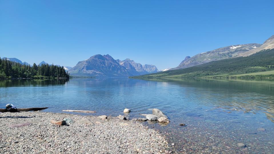
After trudging for about three miles, we turned around and stopped at St. Mary Lake for lunch, which included mangoes we brought from Florida for our friends. Some of us used the opportunity to stick our tired feet in the ice-cold water while soaking in the vista. The multicolored rocks on the lake floor were pretty awesome.
Next, we headed for Two Medicine with a notion to visit Twin Falls. But once we realized what it would take to get there given that we already had done some hiking, we opted instead for a 2-mile hike along Two Medicine Lake with a stop at Paradise Point before making our way to Aster Falls.
We saw a deer, but another group told us they had seen a moose enjoying an afternoon drink at a nearby lake. It was gone by the time we got there.
Day 2: Bullhead Lake; parts beyond
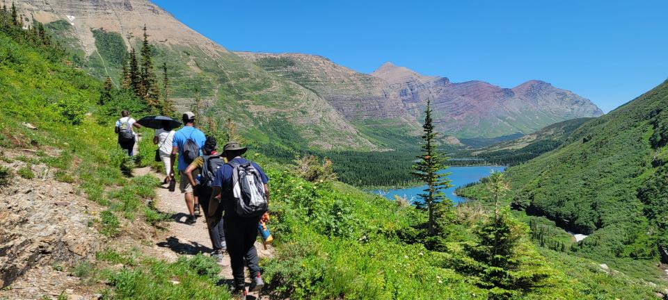
Our friend Audrey had identified Bullhead Lake in the popular Many Glacier area on the east side as a relatively easy hike for our group, so we were all on board for the trek along the Swiftcurrent Pass Trail that would take us through the Swiftcurrent Valley. The gentle terrain meant we wouldn't have to work too hard to cover the approximately four miles to the lake.
Along the way we passed the lovely Red Rock Falls but didn’t linger because we wanted to get to our goal and the temperature was rapidly rising. By the time we got to Red Rock Lake, we were due for a break so we paused and soaked up that view.
Bullhead Lake exceeded our expectations. We got great views of Swiftcurrent Mountain and Swiftcurrent Glacier, and a lone duck in the middle alternately chilling and diving was quite the sight. That duck swam and dove to its heart’s content, oblivious to onlookers.
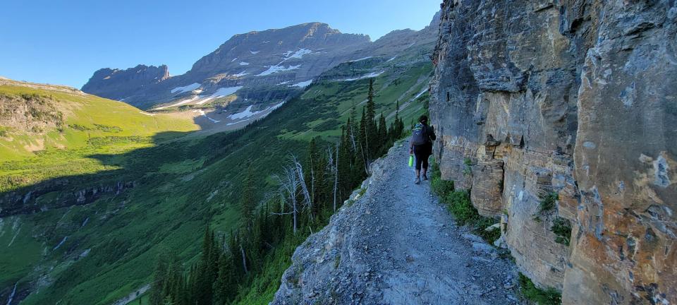
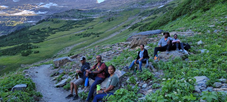
We had snacks and relaxed for a while before, emboldened by the ease with which we had reached our goal, we decided to aim higher — as in taking on switchbacks (trails that zig-zag) en route to the top of Swiftcurrent Pass.
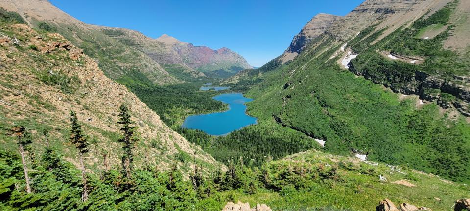
The switchbacks were no joke, but we powered through, albeit slowly and with frequent stops along the way. Temperatures into the mid-90s made a challenging hike even more difficult. After reaching an overlook that allowed us to view the valley and some of its lakes — Bullhead, Red Rock and Fishercap — we were pretty much done. It had been a struggle, but that view was so worth it. We even spotted a moose drinking at Bullhead Lake.
It was then we realized that while we had more than enough water for our initial trip, we would be short for the extended journey. The high temps meant we had been chugging, not sipping our water.
My husband and I eventually got ahead of our group but kept in touch via walkie-talkies as we got farther away. We got back to the parking lot long before our friends did, so he got water to take back to them since they had run out by that point.
Lesson: Bring more water than you think you might need. The beauty of the park might lure you way beyond your planned destination.
For dinner, we drove to Two Sisters, just north of St. Mary Village. Assured by the gentleman at the desk that they were the only game in town at that hour, we resigned ourselves to waiting, and were seated after about 45 minutes.
As we were leaving, the gentleman asked where we were from. I told him Florida. He said, “Yes, but you’re from somewhere else.” I told him Jamaica, which led to a whole conversation about his visits to the island, his love of Ocho Rios and how much he loved jerk dishes but not the national dish of ackee and saltfish. He was great!
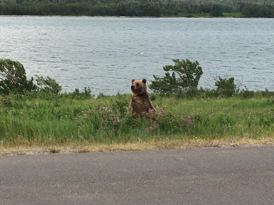
On our way back to our cabins, we spotted movement in the nearby brush and voila! Just like that, there was a large brown bear (which actually was black) going about its business of what appeared to be foraging for dinner.
The quiet of the car ride ended abruptly as we started yelling while trying not to, because we didn’t want to scare the bear, and everyone reached for their phone to snag a picture. A definite wildlife appreciation moment.
Day 3: Going-to-the-Sun Road Shuttle
We bought tickets on June 1 for the shuttle , figuring a day or two riding it would allow everyone to enjoy the scenery without any risk of a distracted driver. The nominal $1 cost is part of the park’s crowd-control strategy in the time of COVID-19.
We picked up our wristbands for the ride at St. Mary Visitor Center. As we exchanged good-morning greetings with the pleasant ranger handing out the bands, I asked how he was doing. “I’m great! Can’t you see I’m working in a painting?” he said. Framed as he was by the mountains, it was a picture-perfect statement.
We boarded the shuttle heading west to Logan Pass, the highest point along Going-to-the-Sun Road, where we hoped to visit Hidden Lake and check out the Continental Divide. But a sign informed us that the trail was closed because a mama bear and her cubs were roaming the area.
The other option, Highline Trail, was closed because of snow, so we milled about the short trail near the visitor center before getting back on the shuttle and heading east.
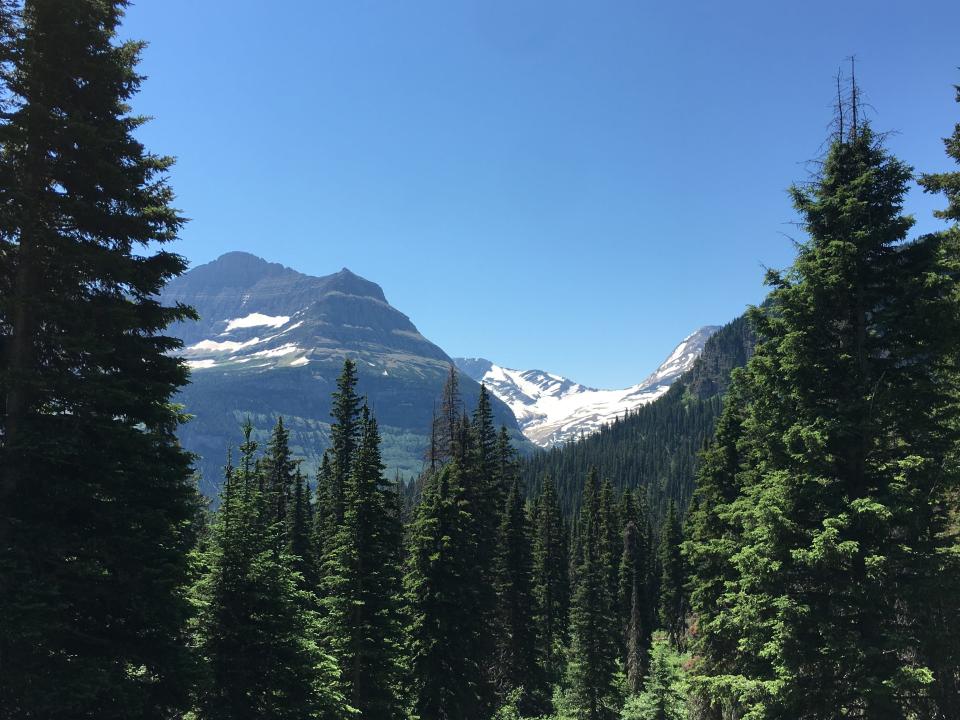
We stopped at the Jackson Glacier overlook, which afforded a clear view of the glacier. The area isn't very big, so we got out of the way quickly to let other visitors have a look. We then took a short hike of about a mile along the Gunsight Lake Trail before turning back.
Like many of the glaciers in the park, Jackson is receding at an alarming rate. According to the National Park Service, at the end of the Little Ice Age around 1850, there were about 80 glaciers in what would eventually become Glacier National Park, but by 2015, that number had fallen to 26.
Then it was back on the shuttle and on to Sun Point and a nice hike. Our walk took us through a burnt landscape — the scene of the 2015 Reynolds Creek Fire, which consumed about 4,000 acres. Investigators determined it likely was caused by humans. The charred trees and the new growth had a vibe all of their own.
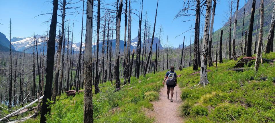
We made our way to the smallish Baring Falls before continuing to the larger and more impressive St. Mary Falls (total of about two miles).. The views of St. Mary Lake had us constantly pausing to reflect on its beauty. Sometimes no words were necessary in our group of six.
Day 4: Grinnell Glacier, and a boat ride
Grinnell Glacier is one of the park’s top attractions, so we rose early and were on the move by 6:45 a.m. because we wanted to avoid the crowded parking lot we had seen a couple days earlier.
As we headed out, we spotted a mama brown (or was it a grizzly?) bear and her cub eating and frolicking on the side of Going-to-the-Sun Road and our excitement hit a new high. For a few minutes it was just us and them. Mama even stood on her hind legs a few times, offering a really neat photo opportunity.
It was as it should be — we were in our car and they were minding their business. In short order, the road was jammed with cars as folks jockeyed for the best position to get a glance. One man even got out of his car — this is a definite no-no. These bears are wild animals and mama bears in particular are completely unpredictable.
The pair eventually crossed the road and headed to the hills.
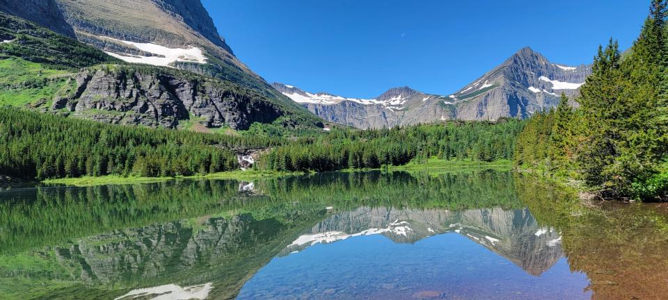
We got to the parking lot just in time to grab the last open spot. It was then that we learned the glacier overlook was closed part of the way because of snow. While we could have hiked part way to the glacier and gotten amazing views, the elevation was a deterrent. We opted to go low and visit Grinnell Lake instead.
Our hike took us along Swiftcurrent Lake and Lake Josephine and we paused at both, but didn't linger because we wanted to take advantage of the cooler morning temperatures.
When we got to the lake, we took a while to enjoy snowcapped mountains, the waterfalls fed by snowmelt and the mix of blues, greens, grays and hints of other hues. Some of us even took turns skipping rocks because some things just never get old.
And as it turns out, it was a bear kind of a day. On our way to catch the St. Mary boat tour, we saw what looked like an older brown bear strolling along the road. Completely unbothered by gawking motorists, that bear just sauntered along. We moved on after it passed us and disappeared beyond the cars backed up behind us. Perfect.
Our guide for the tour — Dylan, a student at Oregon State — was quite knowledgeable and the boat ride was the ideal ending to another day of adventures.
Day 5: More on Going-to-the-Sun Road
Having done the shuttle, we decided to stop at some additional spots along Going-to-the-Sun Road since we were moving to Whitefish, just outside West Glacier, for the remainder of our visit.
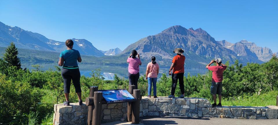
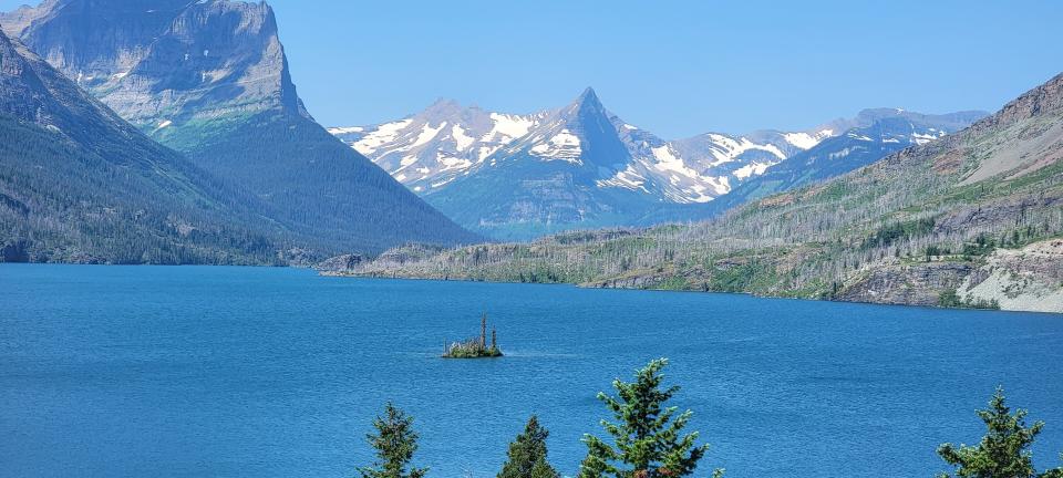
Our first stop was the Wild Goose Island overlook — reportedly one of the park's most popular spots for photos. The view is significant because the tiny island in St. Mary Lake has the mountains of the Continental Divide as its backdrop.
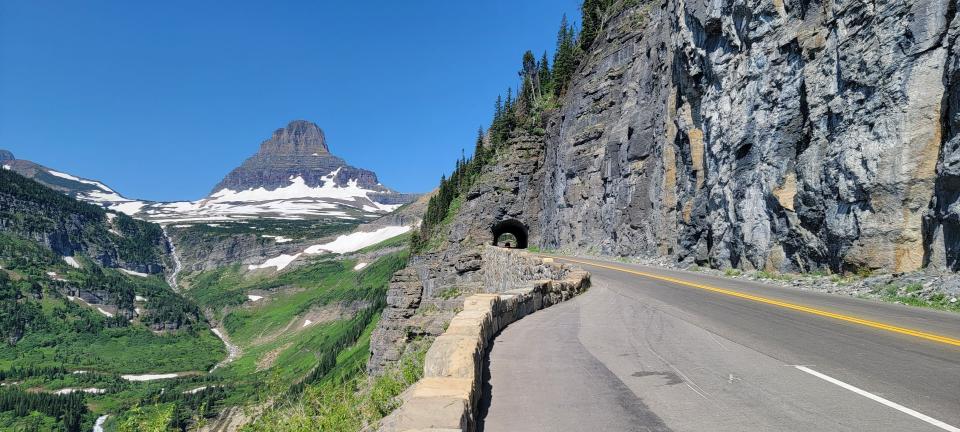
Next stop was to get a look at the East Side Tunnel — one of two such engineering masterpieces along the Going-to-the-Sun Road — and the sweeping vista that frames it.
As we approached Big Bend, we spotted an inviting waterfall and gave in to the moment when we found a parking spot.
We stopped a few more times for random views before arriving at the Apgar Visitor Center. It also was closed because of COVID, but rangers were outside doling out assistance.
We went on a short hike along the Apgar Bike Path and ventured along some other trails before heading into the bustling Apgar Village. A break here meant getting in line at what appeared to be a popular spot in town — the ice cream shop. All of us opted to try the huckleberry ice cream. So yummy.
I had heard of huckleberry (as in Huckleberry Finn and "I'm your huckleberry" — the popular line by Doc Holliday in "Tombstone") but never realized what it was. The sweet, dark purple fruit, which is a favorite of bears, looks similar to blueberries and has a nice tart edge.
We then wandered for a bit along the Lake McDonald coastline and enjoyed the view of its surrounding mountains before heading to our rented house ($579 per night including fees) in nearby Whitefish.
This day was the turning point we had been warned about— it was the start of peak season for the park. There was a marked increase in the amount of traffic and people from only a few days earlier.
Day 6: Highline Trail
Fired up about the prospect of visiting Hidden Lake and to a lesser extent, the Highline Trail, we got to the park just before 6 a.m.
It was already choked with traffic, and when we finally got to Logan Pass at about 6:45 a.m., there was no parking, so we circled back to a nearby lot we had just passed and snagged remaining spot.
The parking spot — downhill from Logan Pass — meant our hiking began ahead of schedule.
The path to Hidden Lake and the Continental Divide was once again closed because of the mama bear and her cub, but the Highline Trail was open.
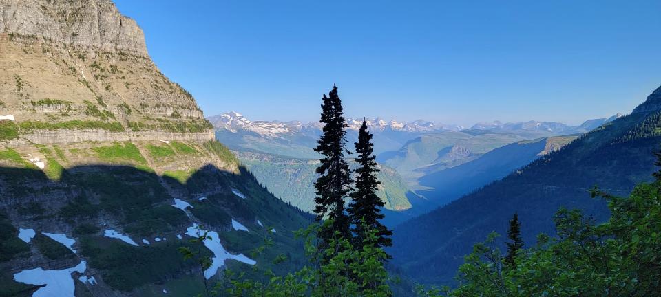
While I initially had balked at even going on the Highline, it was so much easier than I had thought. To say the views were breathtaking is to understate the feast that laid before my eyes. It was hard not to keep stopping to take photos.
The hike started out fairly routine, but then I walked by a mountain goat and soon I was looking down on Going-to-the-Sun Road, which seemed like just a ribbon and the cars on it almost toy-like. If anyone had told me the day before that I would be traversing narrow ledges completely unafraid, I would have told them they were crazy. Now, don’t get me wrong: I wasn’t completely relaxed, but I felt no fear, which is huge for someone who has a reputation for spooking easily.
I just could not get over the views. Hike, pause, look around, hike. Unfortunately, the trail was busy so I soon had to stop pausing for every new angle of a view. We went about three miles before we decided to turn around.
Some of our fellow hikers wore flag shirts and offered greetings of "Happy Fourth," or variations thereof, as we traversed the trail on this Independence Day.
The journey back was a breeze and you couldn’t tell us we weren’t pro hikers.
Day 7: Trail of Cedars, Avalanche Lake
It was our last day in the park, and while there were a few things that we hadn’t seen, we knew we could head home content if we managed to add Trail of the Cedars and Avalanche Lake to our list.
We got to the park shortly after 5:30 a.m. and found a few parking spaces still vacant. Trail of Cedars, a loop of a little more than a half-mile long, is wheelchair-accessible.
We made our way through a section of the loop before veering to the trailhead for the hike to Avalanche Lake. The morning was cool and the vibes just right as we made our way through what is described as the easternmost rainforest in the United States.
The canopy of hemlock and red cedars (some of the trees are believed to be hundreds of years old) that encircled us added an intimacy to the experience despite the presence of other hikers. It was easy to feel like you were at one with the forest, but yet not quite a part of it.
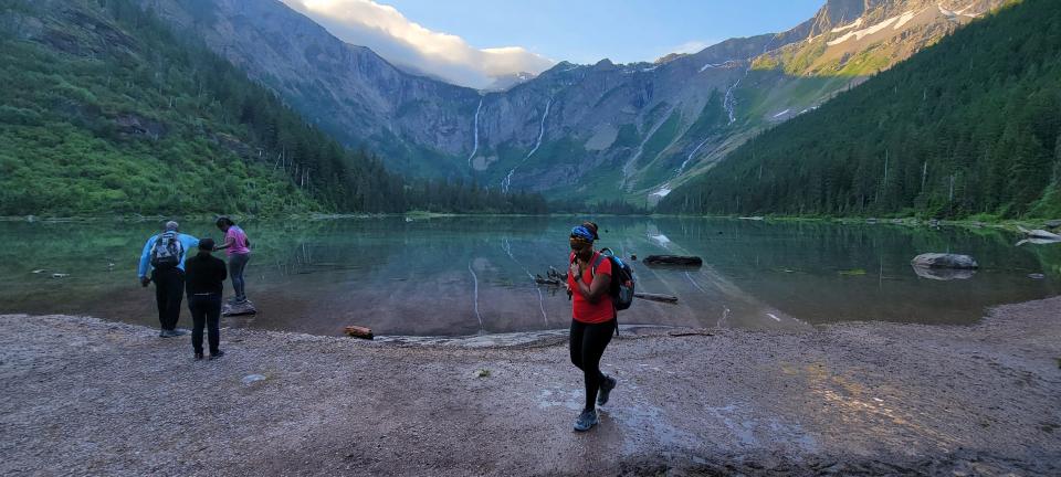
We weren’t sure what to expect when we got to the lake, almost two miles later, but like much of this trip we were open to any and every experience that the park had to offer. And of course, we were not disappointed.
The early morning mist was starting to dissipate as the sun was breaking through, giving an almost otherworldly feel. We had some snacks and sat for a long while to enjoy our surroundings before heading back, completing the Trail of the Cedars on the way.
Satisfied that we had thoroughly explored some key spots and found some less popular ones to enjoy, we left Glacier National Park one last time.
The beauty of the national parks is that while they all feature iconic sights, in the end the experience is very personal and so long as one respects the space and all that it offers, including wildlife, there is no wrong way to commune with nature.
Carol Rose is a USA TODAY Network of Florida journalist. You can reach her at crose@pbdailynews.com. Help support our journalism. Subscribe today.
This article originally appeared on Palm Beach Daily News: Glacier National Park in Montana offers majestic views and brown bears

