North Jersey could now see 6 inches of snow as weekend begins
North Jersey could see up to six inches of snow as the week comes to a close, according to the National Weather Service.
When will the snow start?
Slush mixed with rain could develop over the area Friday evening, said Jay Engle, a meteorologist with the service.
That could switch to pure snowfall late Friday night into Saturday morning, he said.
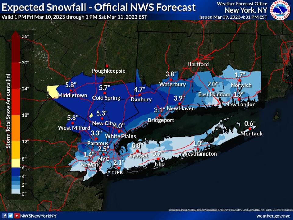
How much snow will get?
Here is what the NWS is predicting for the Metro New York area:
West Milford 5.8 inches
Ringwood 4 inches
Wantage 4-6 inches
Paramus 3.3 inches
Morristown 3-4 inches
New York City 2.5 inches
Newark 1.4 inches
Hackensack 2 inches
Bergenfield 2 inches
Ramsey 4 inches
Lyndhurst 2 inches
Ridgewood 3 inches
Winter Weather Advisory
The NWS has a winter weather advisory in effect for the area from 6 p.m. Friday to 10 a.m. Saturday.
Next week's forecast
At the start of next week, temperatures could drop to below normal as a jet stream moves over the Northeast and Mid-Atlantic regions, according to a forecast issued by the NWS' Mount Holly station.
More:NJ had record high temperatures, low snowfall this winter. What's ahead for spring?
Slippery roads
The Hackensack Office of Emergency Management issued an alert on Thursday warning of inclement weather leading to slippery conditions for the Friday evening commute.
This article originally appeared on NorthJersey.com: North Jersey has snow in weather forecast to start weekend

