Bermuda Triangle revives a 'zombie' storm in time for Halloween
Tropical Storm Tammy sprang back to life over the central Atlantic Ocean on Friday, scoring a comeback as unlikely as the storm’s very existence.
The storm found a favourable environment near Bermuda to revive itself and prove the naysayers wrong, a zombie-like achievement that’ll keep this storm’s second wind blowing through Halloween next week.
DON’T MISS: It's not just your imagination, Atlantic storms are getting stronger faster
Tammy is back as a tropical storm after being extra-tropical (e.g., non-tropical) for a couple of days. Tammy is the first Atlantic storm to be a #hurricane, then extra-tropical and then come back as a tropical storm since Paulette (2020). pic.twitter.com/pX09O9jqcJ
Philip Klotzbach on Twitter: "#Tammy is back as a tropical storm after being extra-tropical (e.g., non-tropical) for a couple of days. Tammy is the first Atlantic storm to be a #hurricane, then extra-tropical and then come back as a tropical storm since Paulette (2020). pic.twitter.com/pX09O9jqcJ / Twitter" is back as a tropical storm after being extra-tropical (e.g., non-tropical) for a couple of days. Tammy is the first Atlantic storm to be a Philip Klotzbach on Twitter: "#Tammy is back as a tropical storm after being extra-tropical (e.g., non-tropical) for a couple of days. Tammy is the first Atlantic storm to be a #hurricane, then extra-tropical and then come back as a tropical storm since Paulette (2020). pic.twitter.com/pX09O9jqcJ / Twitter", then extra-tropical and then come back as a tropical storm since Paulette (2020). Philip Klotzbach on Twitter: "#Tammy is back as a tropical storm after being extra-tropical (e.g., non-tropical) for a couple of days. Tammy is the first Atlantic storm to be a #hurricane, then extra-tropical and then come back as a tropical storm since Paulette (2020). pic.twitter.com/pX09O9jqcJ / Twitter"
— Philip Klotzbach (@philklotzbach) Philip Klotzbach on Twitter: "#Tammy is back as a tropical storm after being extra-tropical (e.g., non-tropical) for a couple of days. Tammy is the first Atlantic storm to be a #hurricane, then extra-tropical and then come back as a tropical storm since Paulette (2020). pic.twitter.com/pX09O9jqcJ / Twitter"
Tammy pulls the ultimate party trick for Halloween
Tropical Storm Tammy formed near the Lesser Antilles back on October 18, growing into a hurricane before making landfall on Barbuda on October 21 with maximum sustained winds of 140 km/h.
Tammy spent the following week slowly pulling away from the Caribbean as it maintained hurricane strength.
Like many storms this time of year, Tammy seemed to meet its fate as it merged into a cold front pushing across the western Atlantic Ocean.
MUST SEE: Tammy tips 2023 into Atlantic's fourth-most active hurricane season
The U.S. National Hurricane Center (NHC) issued its final advisory on Hurricane Tammy at 5:00 a.m. on October 26, declaring that the system no longer had tropical characteristics.
30 hours later, however, the storm had its own ‘Dewey Defeats Truman’ moment of sorts.
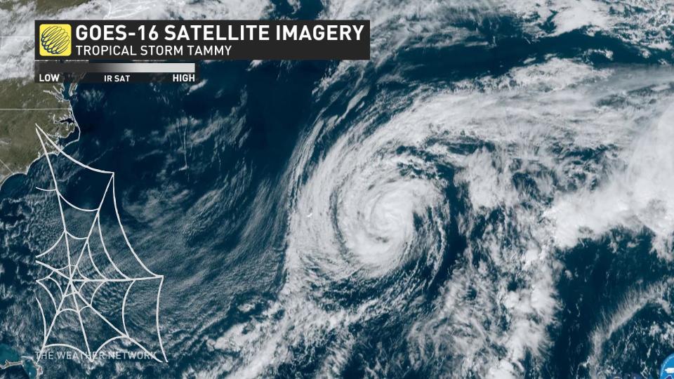
The system broke free of that cold front east of Bermuda and thunderstorms began to bubble again near the centre of the storm. These thunderstorms quickly organized, allowing the system to recombobulate and once again earn the title Tropical Storm Tammy.
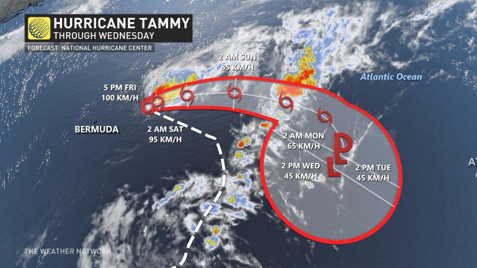
Forecasters expect a refreshed Tammy to meander in the central Atlantic Ocean for the next five days, drifting east through the beginning of November as it fizzles out for the second and probably last time.
Storm systems are diverse and complex
How did Tammy lose its identity and come back to life a day later? The answer lies within all of us. Much like humans, low-pressure systems exist on a spectrum that makes it hard to fit these natural wonders for a label.
All low-pressure systems are cyclones, and there are different types of cyclones depending on their characteristics.
READ MORE: How hot water fuels the world’s most powerful hurricanes
Extratropical cyclones are the common lows that send cold air and warm air churning around the globe. These storms feed their energy from strong upper-level winds pulling air away from the surface, deepening the centre of low pressure.
Tropical cyclones develop when powerful thunderstorms draw air away from the surface, leaving behind less air—and lower air pressure—in their wake. A tropical cyclone features warm air throughout the storm, and it feeds its energy almost entirely from warm ocean waters fuelling those thunderstorms.
But not all storms neatly fit within these two boxes. There are hybrid storms—like Fiona in 2022 and Sandy in 2012—that fall somewhere in the middle of the spectrum, featuring characteristics of both types of storms.
And it’s possible for a storm to drift back and forth as it interacts with its surroundings. Tammy’s transition from hurricane to post-tropical and back to a tropical storm again is a great example of how fluid these formidable storms can be depending on the environment around them.
A fitting storm for a quirky year
Tropical Storm Tammy’s regeneration is a perfect footnote for a storm whose entire existence is relatively unlikely. This has been an incredibly active hurricane season in the Atlantic basin, far exceeding averages with 20 tropical storms or hurricanes so far this year. (Our first storm was an unnamed system that formed back in January.)
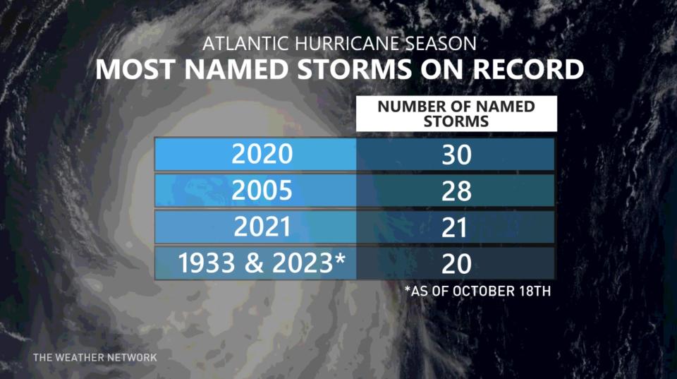
That would be a noteworthy feat during any hurricane season—2023 is now tied for the fourth-most active season on record—but the basin managed to churn out one storm after another despite a strong El Niño over in the eastern Pacific Ocean.
El Niño tends to suppress Atlantic hurricane activity by increasing wind shear that can destroy a storm before it has a chance to develop. This year, though, unprecedented warmth across the Atlantic helped to supercharge the season.
Header image courtesy of NOAA.

