Berrien County sets priorities for bike, boat and horse trails
While the December holidays came and went, Berrien County adopted a master plan for extending trails that not only crisscross evenly within its borders but that connect to one another.
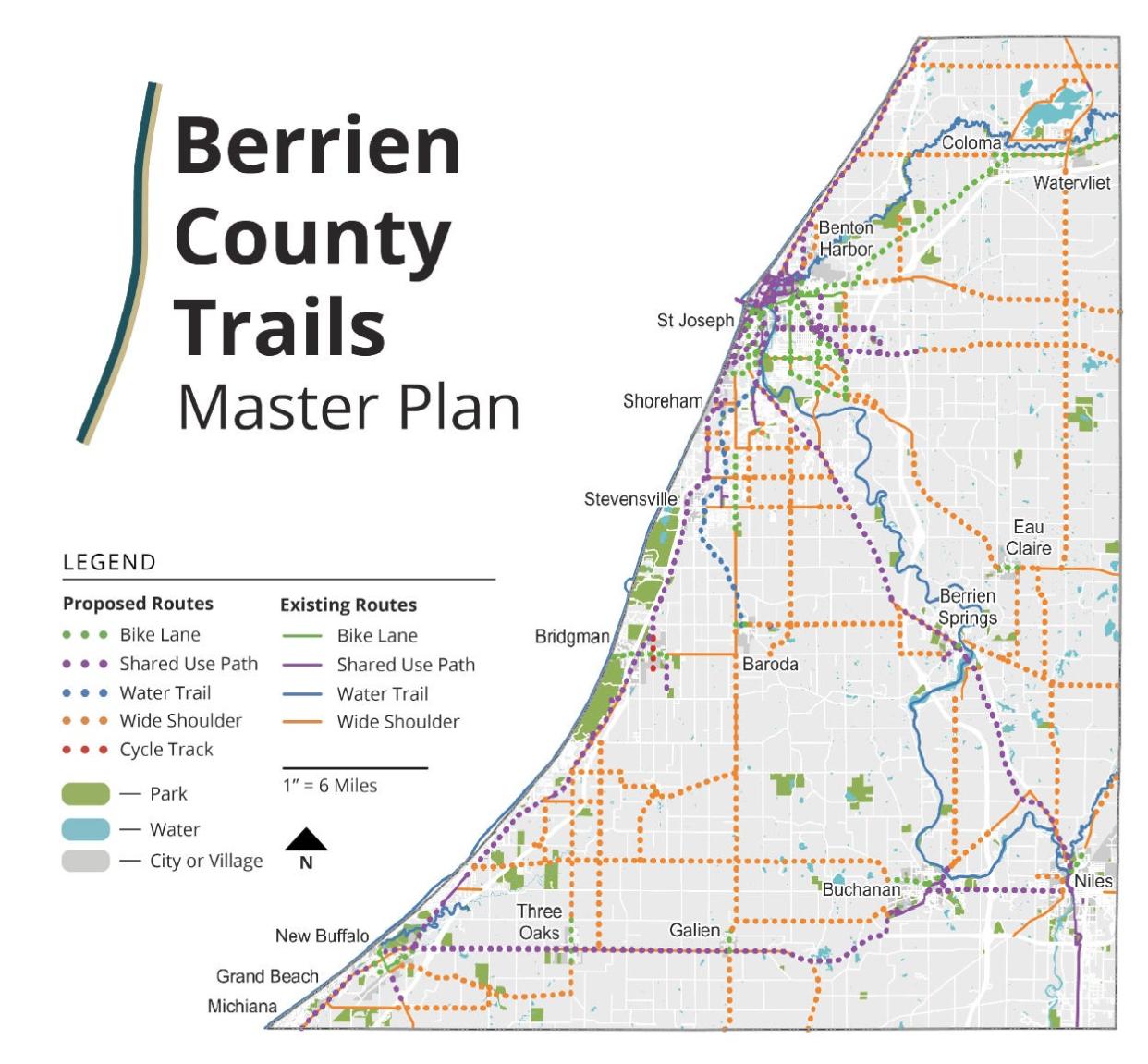
It’s a wish list, yes, but also a guide for government officials to say these 372 miles of proposed routes are priorities for at least 10 years — if officials have the funding and desire to add safer places to bike, walk, roll wheelchairs, paddle boats and ride horses.
It’s the county’s first-ever Trails Master Plan, in the works since 2019, having gleaned suggestions from area residents in forums and outreach efforts.
It proposes 45 miles to be added to the nearly eight miles of bike lanes, 110 miles to the existing 35 miles of paved trails and 192 miles to the existing 95 miles of widened shoulders along roads. The Friends of Berrien County Trails (www.berrientrails.org) tout the routes as connecting “schools, parks, beaches, shopping areas, medical facilities and major employment centers.”
The plan also proposes adding 24 miles to the existing 122 miles of water trails in the county. Water trails mean ensuring that there are access points for paddlers and that, when trees block the waterway, someone regularly goes in to cut openings.
The plan suggests a water trail along Hickory Creek from Baroda to the St. Joe River in St. Joseph, as well as on the Galien River from Glendora Road in New Troy to Glassman Township Park, adjacent to Interstate 94.
And the plan encourages creating equestrian trails because, at this point, there are none in Berrien County. It suggests a couple of opportunities: One would be on land that Berrien County Parks is exploring near the Watervliet Municipal Airport and Paw Paw River. The other horse trail would be on Andrews University land south of Berrien Springs that the Michigan Department of Natural Resources is in the works of acquiring.
For bicyclists, the plan includes a suggested network of roads where shoulders could be widened for better riding when the county road department is repaving roads. This wish list/map provides priority routes that local cyclists have suggested through the feedback process. But, to become reality, Hamilton said, it will also require the local township to lend its support with funding or a grant.
Read the 142-page master plan and find an interactive map to zoom in on the proposed routes at https://www.berrientrails.org/bcmasterplan.asp.
The county's new plan has been introduced to 39 townships, municipalities and other local governments, hoping they’ll pass resolutions of support, though the resolutions don’t bind them to provide funding. Hamilton has gotten word on nine resolutions so far.
The Berrien County Board of Commissioners adopted the master plan on Dec. 1.
Broader trail planning in 2019:Berrien County dreams of trails, like a link from Niles to Berrien Springs
“This is the first time we looked at all the trails throughout Berrien County and saw that there is a real opportunity to fill in the gaps and create a connected regional network,” Marcy Hamilton, senior planner and deputy executive director of the Southwest Michigan Planning Commission, says.
The plan has been led by Hamilton, Friends of Berrien County Trails President Gary Wood, Be Healthy Berrien and Abonmarche Consultants.
“It is the final plan, but it can always change as new information is discovered,” Wood says.
Berrien 'backbone'
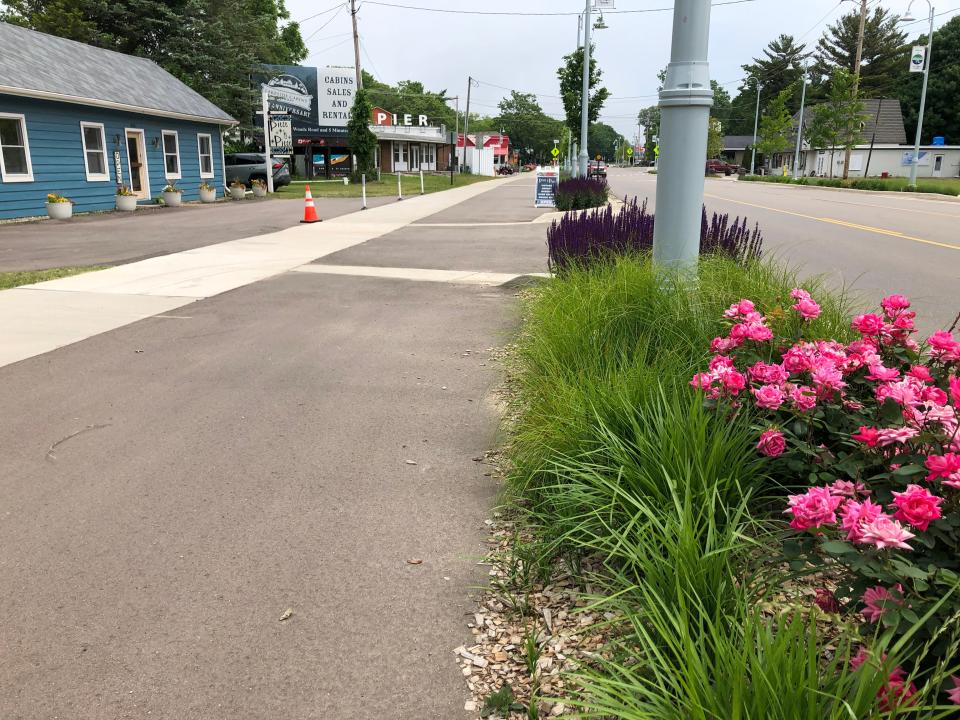
Now, here’s a look at what Hamilton and trail planners call a “backbone system” of paved trails. These trails, if completed, would form a triangle linking Niles, St. Joseph and New Buffalo.
∎ Marquette Greenway: This past fall, organizers raised the final $300,000 needed to completely build the Michigan portion of Marquette Greenway, a 3.8-mile section that totals $5.6 million in cost. Work on the first phase of the Michigan portion, from downtown New Buffalo to Grand Beach, will begin early this spring or summer and finish next year. The second phase, taking it along Grand Beach Road to the Michigan line, would be finished in 2025.
When done, the Marquette Greenway will be a 60-mile trail from Chicago to New Buffalo. The Illinois portion is done, but officials say the Indiana sections need about $4 million to be raised so they can be paved by 2027. That’s in addition to a $17.8 million federal grant and several other funds that have been secured.
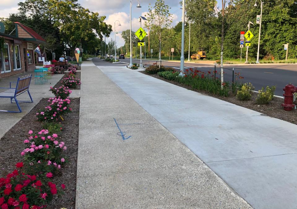
∎ Red Arrow Highway trail: Piece by piece, the initial parts of this backbone trail close to Lake Michigan are coming together, with the hope of connecting New Buffalo to the county’s northern edge. It's being created through a “road diet” that reduces vehicle traffic from four to three lanes along the Red Arrow Highway, which provides room to build a separated trail. It would extend from the Marquette Greenway.
A 1.3 mile section in Union Pier was finished in 2021. Another 1.5-mile section north of that was built in 2022, starting from the Harbert Community Park in Harbert and going north to Sawyer. There’s a gap between those two sections. For now, Hamilton points out that cyclists can (and do) find a connection between that gap by using the quiet, residential Lakeshore Road, parallel to and west of Red Arrow Highway.
Hamilton says organizers are now trying to arrange another section of trail from Union Pier south to U.S. 12. And trail advocates in Benton Harbor are working on a trail from Harbor Shores/Jean Klock Park north to the Whirlpool Corp. campus.
∎ Indiana-Michigan River Valley Trail: This trail, which currently runs from Mishawaka to Niles, recently gained $900,000 in funding through U.S. Rep. Fred Upton to build the next section from Plym Park to Pucker Street in Niles. North of that, dreams call for extending it to Berrien Springs, but Hamilton and other organizers are still trying to secure a route. She says one tricky part between Walton and Fairland roads requires the costly, time-consuming work of title searches to determine who owns certain slivers of land.
August 2021:A push to create a trail from Niles to Berrien Springs is taking longer than expected
∎ McCoy’s Creek Trail: An extension of this five-mile trail, which links two natural areas and passes through Buchanan, will be built in 2024, going east for another mile to the River St. Joe farmstead brewery. Local organizers are also working on another three-mile extension along Walton Road to reach a future portion of the Indiana-Michigan River Valley Trail.
∎ Old Sauk Trail: It’s just a line on a map for now, a dream, but the concept is to build a trail running east-west from New Buffalo to Buchanan. For now, Hamilton says, the concept would place it along the side of U.S. 12.
Is winter back?:Join a snowy winter fest, watch for comet or check out boat show
Find columnist Joseph Dits on Facebook at SBTOutdoorAdventures or 574-235-6158 or jdits@sbtinfo.com.
This article originally appeared on South Bend Tribune: Berrien County trails plan suggests routes for bikes, paddling, horses

