Best family-friendly hiking trails in Phoenix this spring — and most are free
In Arizona, a summertime trifecta of excessive heat at low elevations and the potential for wildfires and forest closures in the high country can challenge even the most determined hikers.
When escape to cooler mountain climes isn't an option, the scramble to find suitable hikes that are close by, offer a little shade and are entertaining for kids and satisfying for adult hikers can be challenging.
But it is possible to hike safely during the Phoenix inferno months by hitting local trails early in the morning (we’re talking be done by 9 a.m.). Take plenty of water; don a hat, sun-protective clothes and sturdy footwear; and always tell somebody where you are going and when you expect to return.
Here are family friendly trails in metro Phoenix that kids and grownups will enjoy.
Best parks in Phoenix: 5 places with playgrounds, hiking, pools and more fun things to do
Phoenix: Rio Salado Habitat Restoration Area
Just 2 miles south of downtown Phoenix, where the Salt River once flowed, a former dumping ground has been transformed into a thriving 595-acre oasis in the desert.
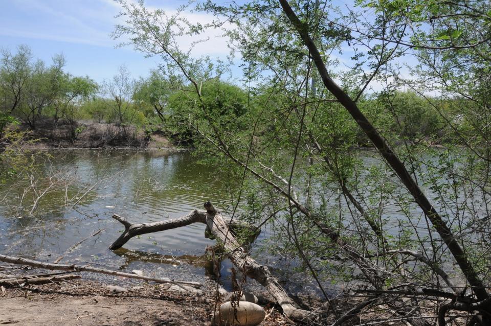
With the cooperation of the Army Corps of Engineers, the Flood Control District of Maricopa County and droves of volunteers, tons of waste were cleared out of the Salt River channel and replaced with ponds, waterfalls and tens of thousands of indigenous plant species.
Although the revitalized strip of riparian habitat looks as if it occurred naturally, it’s a “demonstration wetland” that was created by tapping into the groundwater beneath the river channel and pumping more than 2.6 million gallons of water per day to sustain the habitat.
Trail segments are organized to feature specific desert habitats such as cottonwood-willow, lower Sonoran, mesquite bosque and paloverde. The area is flush with native plants that were harvested from seeds or cuttings within a half-mile of the Salt River. Snowy egrets, raptors, toads and dozens of other species have settled into the reedy shores and shaded coves.
Length: 13.8 miles of trails.
Rating: Easy.
Elevation: 1,010-1,070 feet.
Where: There are six trailheads in Phoenix:
2801 S. Seventh Ave.
2439 S. Central Ave.
3131 S. Central Ave.
3212 S. Seventh Ave.
3203 S. 16th St.
The trailhead at 2875 S. Seventh St. is closed.
When: Sunrise to 7 p.m. or sunset, whichever comes first.
Admission: Free.
Facilities: Restrooms at some trailheads.
Details: https://www.phoenix.gov/parks.
The secret to summer hiking in Phoenix: Get out early. Here are 4 scenic trails to try
Gilbert: Riparian Preserve at Water Ranch
The sound of waterfowl is deafening. Even with its proximity to U.S. 60 and a busy community center, a hike in this wetland complex of seven ponds and a fishing lake mimics a stroll in a wilderness marsh.
The groundwater recharge basins are surrounded by extensive vegetation that attracts thousands of shorebirds, making for a shady hike in warm weather.
Great blue herons, snowy egrets, long-billed dowitchers, mallards, grebes, killdeer, warblers and hummingbirds are easy to spot. Short loop trails with interpretive signs weave among flower gardens, mesquite bosques, nesting sites and feeding grounds. For hard-core birders, viewing blinds are set up along the shores.
In addition to the hiking trails, the site features a playground with educational activities (dinosaur dig, anyone?), an observatory and a hefty events calendar. Leashed dogs are allowed; owners must clean up after their pets.
Length: 4.5 miles of trails.
Rating: Easy, barrier-free.
Elevation: 1,200 feet.
Where: 2757 E. Guadalupe Road, Gilbert.
When: 5:30 a.m.-10 p.m. daily. Trails open dawn to dusk.
Admission: Free.
Facilities: Restrooms.
Details: https://www.gilbertaz.gov.
More: Gilbert Riparian Preserve has loads of free family fun. Here's what you can do there
Buckeye: Skyline Regional Park
Anchoring the maze of paths that wind through 8,600-acre Skyline Regional Park, the Turnbuckle Trail offers an excellent introduction to the park’s mix of easy strolls and challenging mountain climbs among the washes and foothills of the southern White Tank Mountains.
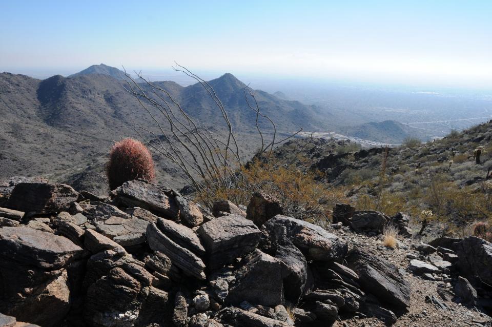
Although it's just 2 miles north of Interstate 10, the blissfully quiet site has a wild yet accessible feel. Begin your hike at sunrise to finish before the heat of day sets in.
Like most hikes in the park, Turnbuckle begins with a stroll across a graceful, oxidized bridge spanning Mountain Wash. It loops around a prominent mountain peak and connects with Valley Vista Trail for an optional 0.3-mile, difficult climb to a vertigo-inducing summit. This short trek involves some steep, narrow sections with drop-offs.
Length: 4 miles round trip.
Rating: Moderate.
Elevation: 1,500-2,300 feet.
Where: 2600 N. Watson Road, Buckeye.
When: Trails are open sunrise to sunset. Gates close at 10 p.m.
Admission: Free.
Facilities: Restrooms, picnic tables, campsites.
Details: https://www.buckeyeaz.gov/community/skyline-regional-park.
More Skyline Regional Park: If you want peace and quiet, this hike is for you
Cave Creek: Jewel of the Creek Preserve
Showcasing the desert foothills and thriving riparian environment surrounding the Jewel of the Creek area of perennial Cave Creek, this unexpected strip of lush creek-side willows, alders, walnut trees and cattails is hemmed in by rugged Sonoran Desert terrain making for a breathtaking hybrid desert-wetland hike. You’ll also wander through a mesquite bosque, the fifth rarest ecosystem on Earth.
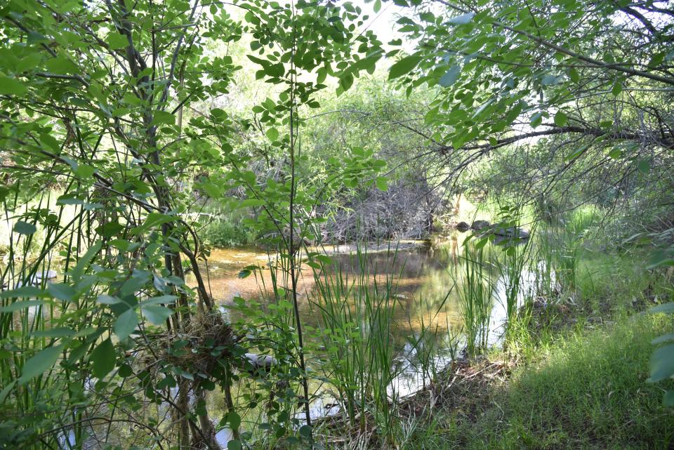
Although most hikers grab a map at the trailhead and head out on their own, park ranger Kevin Smith — who knows just about everything about the local flora, fauna, geology and human history of the area — conducts regular guided tours for those who would like an educational experience. See the website for a schedule.
We can thank the Desert Foothills Land Trust for securing the preservation of this delicate ecosystem and raising the funds needed to plan and build the trail.
Length: 1.9 miles for the creek loops.
Rating: Moderate.
Elevation: 2,400-2,150 feet.
Where: 44000 N. Spur Cross Road, Cave Creek.
When: 6 a.m.-8 p.m. Nov. 1-April 30. 5 a.m.-9 p.m. May 1-Oct. 31.
Admission: $3 per person in cash (exact change required).
Facilities: Portable toilets at Spur Cross Ranch trailhead.
Details: https://www.dflt.org, https://www.maricopacountyparks.net.
Cave Creek hike: This old mine yielded a fortune in beauty products
Read more of Mare Czinar's hike recommendations at arizonahiking.blogspot.com.
Support local journalism. azcentral.com
This article originally appeared on Arizona Republic: Best kid-friendly hikes in Phoenix, and most are free

