Beware Dallas: Dangerous, disruptive flash flood threat looms

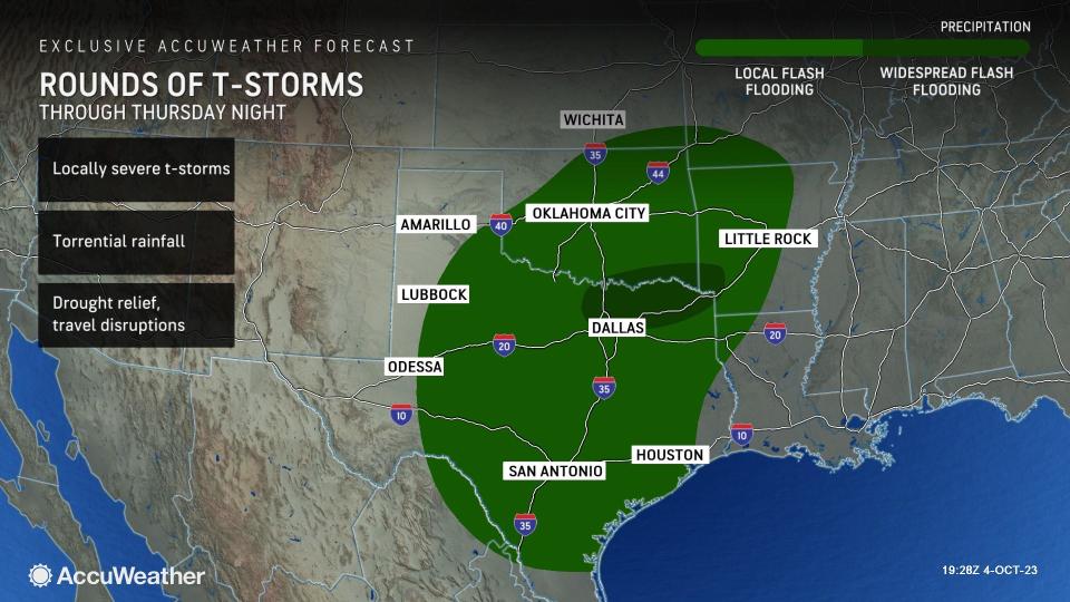

As a strong push of Canadian air pushed across the southern Plains, the handoff from very warm to cool conditions set off torrential downpours that helped to ease short-term drought conditions but also led to dangerous flash flooding in portions of north-central and northeastern Texas, including the Dallas/Fort Worth Metroplex Wednesday night.
Flash flooding, some turning life-threatening, occurred around Dallas, including interstate 35 and farther to the east in northern Texas, to the north in southeastern Oklahoma and to the northeast in parts of Arkansas.
There is the potential for hourly rainfall to exceed 1 inch through Thursday night, which can easily overwhelm storm drains and catch basins, as well as cause dry streambeds to rapidly fill with rushing water.
 |
When the ground is very dry and hard-packed like it is now, it can behave much like concrete or pavement, AccuWeather Meteorologist Jake Sojda said.
"After an extensive lack of rain, it can take time for the ground to soften [when rain returns] and then become more 'spongelike' and able to more effectively absorb rainfall once again," Sojda explained.
A general 2-4 inches of rain will fall on the zone from northeastern Texas to western Arkansas and eastern Oklahoma through Thursday.
AccuWeather forecasters urge motorists to be prepared for major delays, as some roads may become blocked by high water. Even seemingly shallow areas of water may be subject to a rapid rise that can strand vehicles and create a life-threatening situation in a matter of a few minutes.
Making sure storm drains are free of debris and avoiding parking in low-lying areas that are prone to flooding during torrential downpours are also good measures to take, experts say.
Although the heaviest rain is expected to shift to the east of Dallas around daybreak Thursday, the effects from areas of torrential rain and flooding seen Wednesday night may linger into the morning commute.
 |
There is the potential for torrential rain to extend southward toward the Gulf Coast, affecting travel and outdoor activities in part of the Houston area from Thursday to Thursday evening.
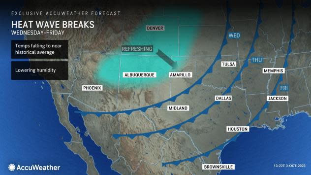
"After an abnormally warm September [and a blistering summer] in the southern Plains and Texas, temperatures more akin to autumn are finally forecast to sweep the region," AccuWeather Senior Meteorologist Courtney Travis said.
In the wake of the cold front and its associated showers and thunderstorms, temperatures will be slashed by 10-20 degrees with much lower humidity levels later this week. The air should feel the coolest it has been since last spring over much of the Lone Star State and neighboring Oklahoma.
Want next-level safety, ad-free? Unlock advanced, hyperlocal severe weather alerts when you subscribe to Premium+ on the AccuWeather app. AccuWeather Alerts™ are prompted by our expert meteorologists who monitor and analyze dangerous weather risks 24/7 to keep you and your family safer.
