With big snow dump coming, here are 10 places to explore in Oregon's mountains
My favorite moments of every winter come after big snow events in Oregon’s mountains and foothills.
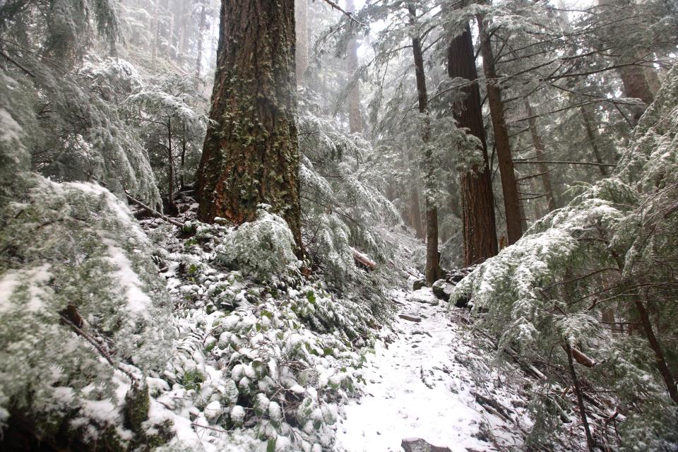
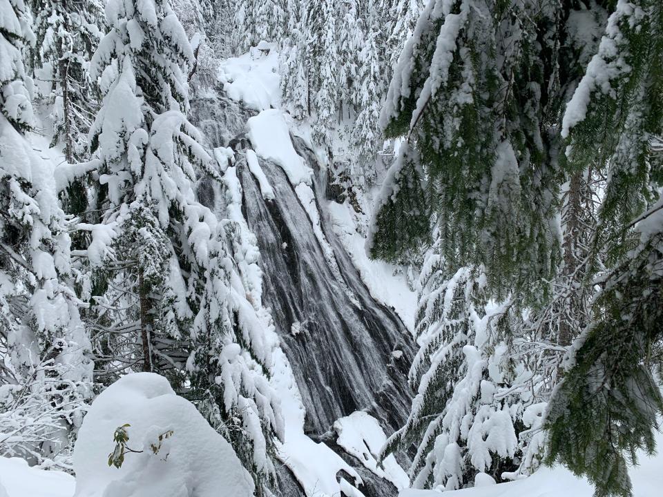
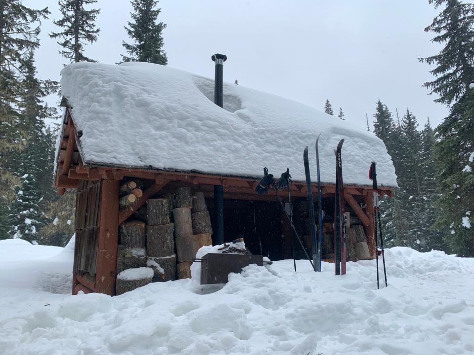
In those moments, waterfalls are transformed, forests turn white, backcountry shelters become cozier and just about every aspect of winter recreation gets more beautiful and interesting.
This coming week, the weather is forecast to bring some major snow to the mountains and even some fairly low elevations, making it a potentially fun moment to try out some new places covered in white.
Of course, nobody knows exactly what the weather is going to bring — this is just an educated guess based on weather models. But even if the snow doesn’t show, or is followed by a bunch of rain, here's a mix of fun, unique and little-known places to explore in the future.
How do you figure out where snow will be?
When I say lower-elevation snow, I’m generally referring to the 1,000 to 3,500-foot range. It’s not unusual to have snow there in winter, but especially lately, it’s also not common to have great snow, either.
The best place to figure out where the snow is falling is the National Weather Service’s website, where you can type in a location — or just click on a map — for a forecast of that specific location.
For example, if I want to figure out whether Silver Falls State Park might get some snow — which creates some beautiful scenes — that’s where I go.
Winter recreation safety
Driving into snowy locations requires planning and knowledge. The places I’m going to feature skew safer, but any trip into the snowy mountains should include a vehicle with snow tires or chains, 4-wheel drive and, most of all, common sense. Numerous Oregon drivers get suck every season after attempting to drive down unplowed snowy roads. If you’re snowshoeing, skiing, snowmobiling or just hiking in the white, make sure to be well-prepared with a map, GPS device and knowledge of your adventure.
Alright, here’s a handful of fun places to visit after a low-elevation snow.
Silver Falls State Park
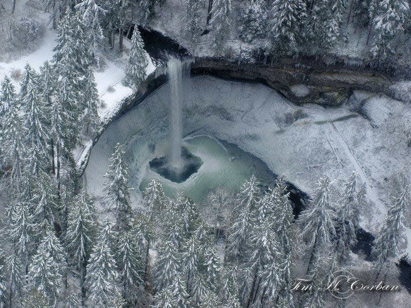
At 1,500 feet or thereabouts, the area’s most famous waterfalls are tough to catch with a coat of white. But it does happen and could happen early next week. If you head out to Oregon’s largest state park after low-elevation snow, just be prepared for icy trail conditions as you head out into the winter wonderland of the Trail of Ten Falls.
Proxy Falls
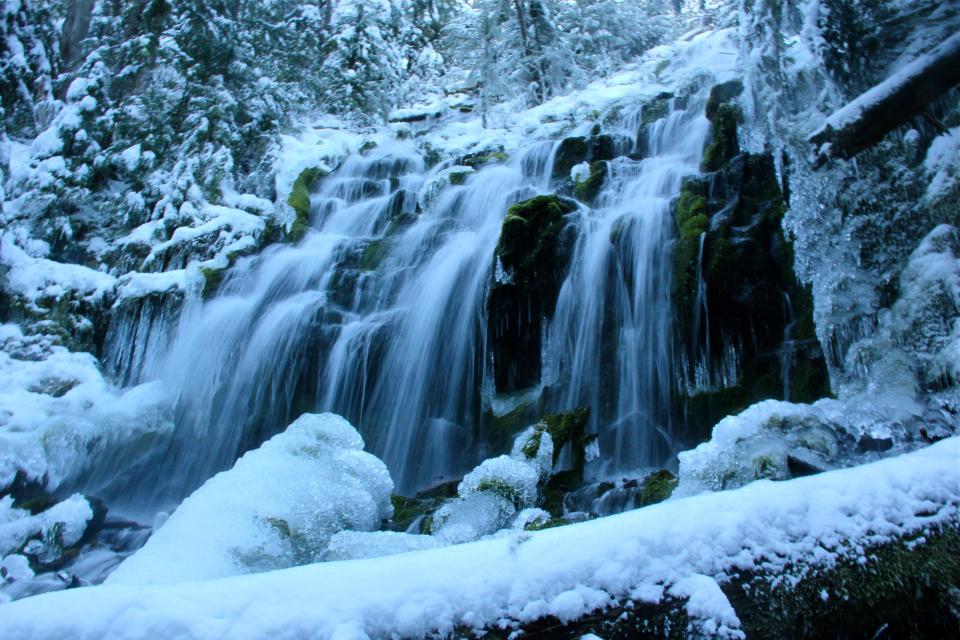
Almost as famous as Silver Falls, this waterfall is a little more likely to have snow and a lot more effort to reach. In summer, it’s one of the state’s most popular waterfall hikes. In winter after a snow, it’s transformed, with icicles hanging off and snow surrounding it.
The trip is challenging, requiring 7 miles round-trip with some navigation of snow-covered trails. The trek begins at the snow gate on McKenzie Pass Highway 242 east of McKenzie Bridge. It begins at 2,100 feet, which may or may not have snow, then travels 2.6 miles and 1,000 feet to the Proxy Falls Trailhead. I used snowshoes as the best option, but some travel in just boots or microspikes. Skis are fine for the highway, but not great for the trail.
Once you reach the trailhead, just hike the route as you normally would. It’s sometimes tough to follow the snowed-over trail, but do your best and you’ll be rewarded with some cool views of both upper and lower falls.
Isaac Nickerson Loop
One of the least-known snowshoe routes in the Santiam Pass area begins at a sno-park with a goofy name.
Ikenick Sno-Park, just off Highway 126, sits at the fairly low elevation of 3,200 feet. Because of that, it often has limited snow and even less visitors.
But it’s a real gem when the snow shows up.
Low-elevation snow opens up one of the best moderate-level snowshoe routes in the area. The Isaac Nickerson Loop is 4.4 miles and climbs 472 feet, passing multiple viewpoints of the Cascade Range and dipping into snowy forest. It's well-marked and easy to follow, combining Forest Service roads 650 and 637 on a lollypop-shaped route.
North Santiam / Parrish Lake route
This unofficial route begins at a pullout for Parrish Lake Road, on the side of Highway 22, and follows snowed-over roads along the North Santiam River to views of Mount Jefferson.
The trip begins at 3,100 feet and one reason I’ve always liked it is the absolute solitude. It’s rare for anyone else to be out here.
The route is 4 miles round-trip, with 400 feet of climb to a Jefferson viewpoint. I’d call it a moderately difficult outing.
The route follows Parrish Lake Road to a bridge over the snowy North Santiam River. Then, turn right on little-traveled Forest Service Road 400 and follow it through the snowy forest. At mile 2, climb a ridgeline to find views of Mount Jefferson.
Sahalie and Koosah Falls
The two most spectacular waterfalls on the McKenzie River are even grander when seen covered in snow.
This classic trek begins at one of a few places off Highway 126 east of McKenzie Bridge. The small pullout at the Sahalie Falls Day-Use Area is the most common place to access the route, but Carmen Reservoir Road is also sometimes open. None of the roads are plowed for recreational use, however, so it can be a crap-shoot.
Wherever you start, the route follows the Waterfalls Trail and McKenzie River Trail on both sides of the river, using a bridge north of Sahalie Falls and Carmen Reservoir Road to connect the loop.
The full route is 3 miles, but you can easily visit just Sahalie or Koosah to shorten your day.
Fey Lake / Big Meadows route
This route is marked and follows the road past views of the North Santiam River, Big Meadows and finally Fey Lake.
The trip begins just off Highway 22 east of Detroit near milepost 75. Park at a pullout from Highway 22 at Big Springs Road, just before Maxwell Butte Sno-Park.
The trek to Fay Lake is fairly difficult at 6.7 miles round-trip and 700 feet of elevation gain. Skis or snowshoes work.
An easier option would be turning back at the scenic viewpoint over the North Santiam River. That route is 3.6 miles round-trip with just 200 feet of climb.
“If you do Fay Lake, you get a guaranteed calendar-quality, close-up view of the North Santiam River filled with large boulders topped with deep snow as you snowshoe over the bridge,” said Lee Slattum, longtime trip leader and snowshoe chair for the Salem-based outdoor club The Chemeketans.
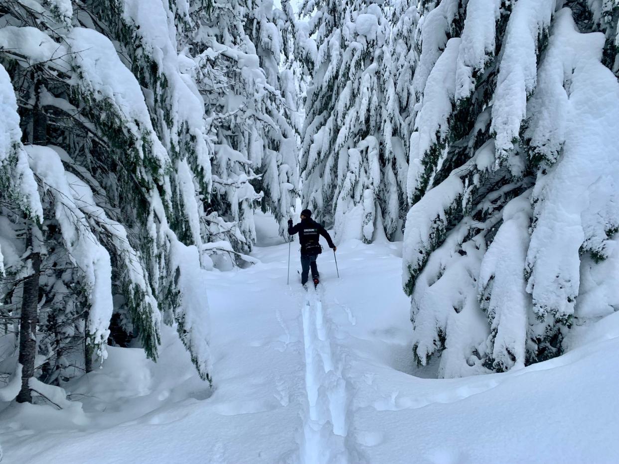
Mountain View Shelter Loop
With seven different trails totaling 22 miles, the network of routes that begin at Maxwell Sno-Park might be the best for snowshoers in the Santiam Pass area.
However, first-time snowshoers often get confused about which route to take, given the myriad junctions and options.
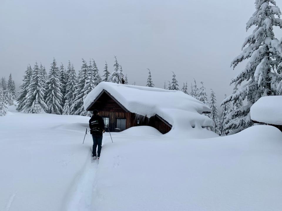
The best overall trip is the Mountain View Shelter Loop. Not only does it offer snowy forest and spectacular views — taking in Mount Washington, the Three Sisters, Three Fingered Jack and Mount Jefferson — but it also has a shelter where you can stop for lunch or the night.
Spending a night at Mountain View Shelter is on a first-come, first-served basis and often fills on weekends.
A good map of the trail system is mandatory—you can find one here. The typical route to Mountain View Shelter is about 5 to 7 miles with 600 to 700 feet of climb (depending on how you choose to travel).
Snowy old-growth climb up Marys Peak
Last week, Bill Sullivan wrote about why Marys Peak is a fun island of snow during the winter in the Coast Range — that “other” mountain range in Oregon.
One that I wanted to add that's especially fun, after a low-elevation snow, is climbing North Ridge Trail, accessed via Woods Creek Trailhead, up the quiet side of Marys Peak. The trip is typically snowless to start, before climbing into the snow. It presents an almost wilderness-like experience, full of solitude and old-growth trees, during the year's coldest months.
North Ridge to the summit of Marys Peak is not easy, requiring 9.5 miles round-trip with a climb of 2,400 feet. The trip might require snowshoes, will definitely require climbing over downed trees and should only be undertaken by those in good shape.
Salt Creek Falls and Diamond Creek Falls adventure
Two of Oregon’s most stunning waterfalls covered in snow and ice is the highlight, beginning at Salt Creek Sno Park off Highway 58 east of Oakridge.
The classic option is an easy 1.5 to 2-mile out-and-back snowshoe trek to 286-foot Salt Creek Falls, a breathtaking sight in winter that looks its best after a nice low-elevation snow. From the snow-park, all that's required is trekking a summer access road to the falls. You can also follow the trails down to a lower viewpoint.
For a grander adventure, venture onto Diamond Creek Loop on a 5-mile trek past another snowy waterfall. Diamond Creek Falls is a glorious sight amid fresh snow. That trip will definitely require snowshoes.
If you’re with kids, there’s also a sledding hill.
Gold Lake cross country ski and snow shelter
The Gold Lake Sno Park area isn’t exactly low elevation or a hidden gem, but I wanted to include at least one three-sided shelter on here because it’s so much fun after heavy snow — it starts to feel like a snow cave. The small wooden shelters have a fire stove and offer a nice place to eat lunch or relax.
There are multiple three-sided shelters you can reach from Gold Lake Sno Park, but my favorite is the one at Gold Lake itself. To reach it, from the parking area, cross over Highway 58 onto Forest Road 500. You'll see a yellow gate that is probably mostly covered in snow and beyond is the pathway.
From here, ski or snowshoe 5 miles round-trip to reach the shelter and views of Gold Lake. After this incoming dump, I expect the shelter would be in full snow cave mode and almost covered up. Which makes it fun.
Zach Urness has been an outdoors reporter in Oregon for 15 years and is host of the Explore Oregon Podcast. Urness is the author of “Best Hikes with Kids: Oregon” and “Hiking Southern Oregon.” He can be reached at zurness@StatesmanJournal.com or (503) 399-6801. Find him on Twitter at @ZachsORoutdoors.
This article originally appeared on Salem Statesman Journal: Snowy waterfalls, cabins, snowshoe trips to do in Oregon mountains

