The biggest, most destructive geological events of 2018
For 4.5 billion years, Earth's fierce geologic forces have created new continents, spawned the world's highest mountains and darkened skies with volcanic ash.
The planet is full of powerful, dynamic systems in constant motion that have led to cataclysmic destruction events and the creation of new life throughout the eons.
2018 was no exception to the ever-changing, churning world beneath our feet. Take a look at some of the year's top geologic events to hit the headlines.
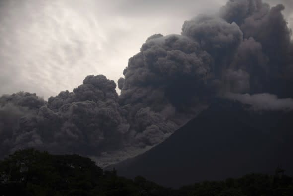
Santiago Billy/AP
Volcan de Fuego, or Volcano of Fire, blows outs a thick cloud of ash, as seen from Alotenango, Guatemala, Sunday, June 3, 2018. (AP Photo/Santiago Billy)
Earthquake shakes the Caribbean Sea
On the night of Jan. 9, a 7.6 magnitude earthquake with a depth of 6.2 miles shook the Caribbean Sea with an epicenter north of Honduras and west of Jamaica.
In its wake, tsunami warnings were sent within a 621-mile radius of the epicenter, but all advisories and warnings were canceled later in the evening.
No damage was reported from this event as many of the nearby areas where sparsely populated, despite the high magnitude and several strong aftershocks.
"We have reports that it was felt in the majority of the country, but we don't have reports of damage," Lizandro Rosales, director of Honduras' contingencies commission, said in a January report.
Despite being of a higher magnitude than the 7.0 quake that struck Haiti in 2010, no significant property damage or loss of life occurred in the region following the 2018 seismic event.
14 die in wake of February Oaxaca earthquake
At 5:39 p.m. local time, a 7.2 magnitude quake with a 15-mile depth rocked the southern Mexico northeast of Pinotepa de Don Luis on Feb. 16.
Although the epicenter of the earthquake was located near the coast, there was no tsunami danger. Oaxaca is often the site of seismic activity due to its location near a tectonic plate boundary and subduction zone.
The oceanic Cocos Plate subducts, or slides beneath, the North American continental plate, leading to frequent releases of building pressures.

During the quake itself, only two injuries were reported at the time. However, in the aftermath, a helicopter surveying the damage crashed leading to the death of 14 people and causing injuries to 15 others.
Nearly one hour after the initial earthquake struck, a magnitude 5.8 aftershock jolted the region with an epicenter closer to the coast.
Nearly a million homes and businesses lost power following the earthquake, which damaged at least 50 homes in Oaxaca, according to Reuters.
Kilauea eruption and subsequent lava flows throughout summer of 2018
While the mighty Kilauea is always an active hot spot and attraction for tourists of Hawai‘i Volcanoes National Park, May 2018 marked a large eruption event that continued throughout the summer.
Beginning on May 3, the ash cloud from Kilauea reached heights of 30,000 feet, according to the United States Geological Survey (USGS). Lava continued to flow in the days and months following the eruption, becoming increasingly steady through August.
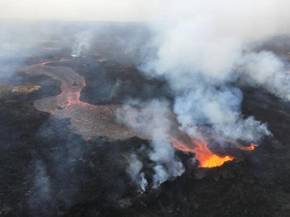
M. Patrick
The ongoing eruption also caused several earthquakes in the region. The increased geologic activity led to the destruction of property, evacuations, road closures, the displacement of thousands of residents and injuries.
On the day of the eruption, 21 active fissures cracked open and 37 structures were destroyed. In addition, at least 10,000 residents were displaced from their homes throughout the month of May.
Sporadic reports of injuries also continued throughout the month including reports of burns as well as a passenger boat struck by rock hurled from the volcano.
Guatemala's Volcán de Fuego eruption claims nearly 200 lives
The deadliest eruption of Guatemala's infamous "Volcano of Fire" since 1923 occurred on June 3 and claimed nearly 200 lives in its wake.
Volcán de Fuego is one of the world's most active stratovolcanoes and is located just 27 miles from Guatemala City.
With almost no evacuation time before the deadly eruption, the June 3 event created devastating lava flows and Lahars, or powerful volcanic, debris flows.
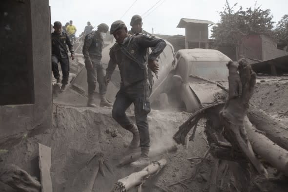
Moises Castillo
Police officers move in the disaster zone near the Volcan de Fuego, or "Volcano of Fire," in Escuintla, Guatemala, Tuesday, June 5, 2018. (AP Photo/Moises Castillo)
Homes were buried in ash while baseball-sized volcanic rocks rained from the skies, leaving a crumpled mass of melted rubber and twisted steel throughout the populated areas in the region, according to CNN.
In addition, lava flows and debris swept through entire villages, wiped out bridges and made areas inaccessible to first responders.
The ground remained so hot following the eruption in some areas that rescuers' boots melted when trying to navigate through the debris, according to the Associated Press.
Indonesian earthquake leads to widespread destruction and more than 2,000 deaths
Through late July and August, several powerful quakes and aftershocks struck Indonesia near Lombok. However, the most devastating geologic event in the region occurred in late September.
On Sept. 28, a magnitude 7.5 earthquake struck near the Central Sulawesi province, triggering a 20-foot-high tsunami along the coastlines and massive landslides across the region.

Rifki
Indonesian men survey the damage following earthquakes and a tsunami in Palu, Central Sulawesi, Indonesia, Saturday, Sept. 29, 2018. A tsunami swept away buildings and killed large number of people on the Indonesian island of Sulawesi, dumping victims caught in its relentless path across a devastated landscape that rescuers were struggling to reach Saturday, hindered by damaged roads and broken communications. (AP Photo/Rifki)
In its wake, the death toll climbed to more than 2,000 people. Thousands more were reported to have suffered serious injuries. Entire families and homes were swept away by the tsunami.
Property damage was catastrophic, with hundreds of thousands displaced and tens of thousands of homes left damaged and destroyed in the aftermath.
The earthquake was initially measured at a magnitude of 7.5 by the United States Geological Survey. About 10 minutes later, another quake struck the area, this one registering as a magnitude of 5.8.
A spokesperson for Indonesia's Meteorology, Climatology and Geophysics Agency (BMKG) confirmed that a tsunami occurred along a shoreline of Palu, one of the most heavily damaged areas.
Volcanic eruption on Indonesian island of Bali strands travelers
Just weeks after the devastating earthquake and tsunami, Mount Agung on the Indonesian island of Bali erupted on Nov. 21.
Several eruptions followed through the next week, forcing airport closures due to ash impeding visibility for aviation.
The volcano erupted twice within a week, stranding around 59,000 travelers at the time.
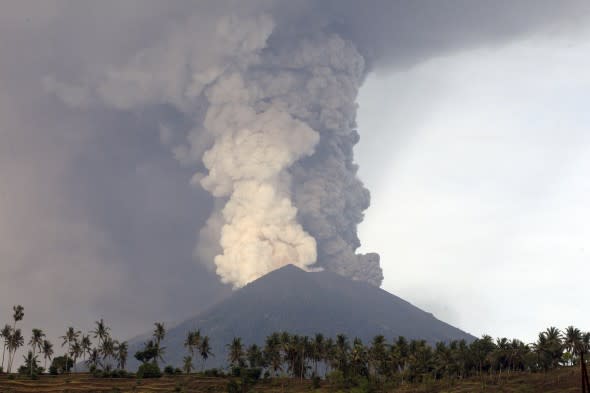
Firdia Lisnawati
A view of the Mount Agung volcano erupting in Karangasem, Bali, Indonesia, Monday, Nov. 27, 2017. (AP Photo/Firdia Lisnawati)
The volcanic eruption led to the closure of the local airport and caused evacuations across the wider radius of the mountain.
Scientists had seen the early signs of the eruption ahead of time and had been monitoring its activity.
Nearly 40,000 people were evacuated from the slopes of Agung to hundreds of refuge shelters.
Earthquake rocks Iran, hundreds injured
On Nov. 25, a magnitude 6.3 earthquake shook western Iran, leading to hundreds of injuries.
According to the USGS, the earthquake was at a depth of 10 km (6.2 miles) and struck 114 km (70.8 miles) northwest of the city of Ilam in Iran's Kermanshah Province just after 8 p.m. in Iran.
In addition, many buildings were damaged in the rural areas of SarPol-e zahab and Qasr-e-Shirin.
Tremors from the quake were felt as far away as Baghdad.
Alaskan quake shakes the city of Anchorage, causes widespread damage

Dan Joling/AP
In this Friday, Nov. 30, 2018 file photo, a vehicle is trapped on a section of road that collapsed during an earthquake in Anchorage, Alaska. The collapsed roadway that became an iconic image of the destructive force of a magnitude 7.0 earthquake and its aftershocks was repaired just days after the quake. The off-ramp connecting Minnesota Drive and a road to Ted Stevens Anchorage International Airport reopened Tuesday, Dec. 4, 2018, with shoulder work finished Wednesday. (AP Photo/Dan Joling, File )
Around 8:30 a.m. local time on Nov. 30, a massive earthquake shook the city of Anchorage, Alaska.
The 7.0 earthquake struck approximately 10 miles north of the city at a depth of 27 miles. Injuries as well as property damage were reported in the aftermath. Many of the injuries were due to lacerations from broken glass.
One person suffered serious airway burns after fighting a fire at his home, which was caused by the earthquake.
Evacuations also took place throughout the city of Anchorage. Employees working in the air traffic tower at the Anchorage Airport were evacuated, as the tower had to be inspected for damage.
In addition, bridges and road infrastructure was damaged during the quake, leading to many road closures.
