Blast of cold air, snow showers to follow storm in eastern Great Lakes, interior Northeast next week


 |
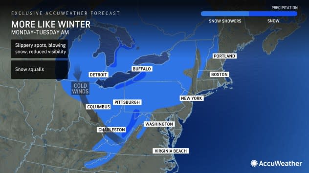
Days before winter officially begins, a brief but noteworthy bout of cold, snow and wind will visit the eastern Great Lakes and portions of the interior Northeast early next week, right on the tail of a massive East Coast storm, say AccuWeather meteorologists.
The episode of wintry weather, happening amid a period of otherwise dry and mild conditions, may last for only 24 to 36 hours in many areas but can produce dangerous travel conditions across portions of Michigan, New York, Ohio, Pennsylvania and West Virginia as early holiday travel gets underway.
"It is really going to feel like winter for a time early next week, with lower temperatures and strong winds expected," said AccuWeather Senior Meteorologist Adam Douty.
Preceding the blast of winter, there will be dry and mild conditions to end the week and start the weekend, with the mercury making it into the upper 40s and even 50s in cities such as Buffalo, Cleveland, Detroit and Pittsburgh. Such temperatures are as much as 10 degrees above the historical average for mid-December.
A powerhouse storm moving up the Eastern Seaboard will spread rain into at least a portion of the area on Sunday and Sunday night. Additionally, a change in pressure between the strengthening storm and high pressure over the northern Plains will kick up the winds to end the weekend and will continue to be a factor well after the storm exits to start the new week.
 |
"Winds across the Great Lakes on Monday as the storm exits could be strong enough to blow around holiday decorations," said Douty. "Because of that, homeowners may want to make sure outdoor decorations are secure."
Wind gusts in the range of 40 to 50 mph are possible from Sunday through Monday night, especially immediately downwind of the Great Lakes. In addition to threatening decorations, the ferocious gusts could bring down tree limbs and cause power outages.
Showers will be accompanied by the wind to start the new week as the jet stream dips south and some energy in the upper levels of the atmosphere moves in. Temperatures will also begin to fall gradually during the day on Monday, changing many rain showers to snow showers by evening.
The combination of the drop in temperature and some frozen precipitation can make travel tricky as early as the Monday evening commute in Michigan, including the Detroit metropolitan area, and even south across portions of Indiana and western Ohio. Roads and sidewalks will turn slippery, and visibility can drop due to windswept snow as temperatures tumble below freezing.
Similar conditions can be expected beginning Monday night farther south and east, through eastern Ohio, West Virginia, western Pennsylvania and western New York. The relatively warm Great Lakes will enhance the snow as the colder air passes over it, and a similar effect can happen in the Appalachians.
"The best chance for accumulating snow will be across areas that would typically expect it during a chilly blast," added Douty. "This includes downwind of lakes Erie and Ontario from northern Ohio into western New York, as well as the upslope areas in the central Appalachians from West Virginia into Pennsylvania."
There is the risk that flurries and snow showers could evolve into heavier snow squalls due to a strong jet stream disturbance pivoting southeastward from Monday afternoon to Tuesday morning, AccuWeather Senior Meteorologist Alex Sosnowski said.
 |
People cross a street during a light snow in West Chester, Pa., Wednesday, Dec. 6, 2023. (AP Photo/Matt Rourke) |
"Sudden snow squalls can make for dangerous driving conditions on the highways," Sosnowski stated.
Because the event will be short-lived, a significant lake-effect snow event is not anticipated, and accumulations should be on the lighter side. Just a few inches at most can be expected in areas where the snow is more persistent; however, even in places where snow can amount to just a coating, such as Greater Pittsburgh, subfreezing temperatures can make for slippery travel as late as Tuesday morning.
After the cold and snow blow through, the weather will quickly return to the relatively quiet and mild conditions that the region has been accustomed to so far in December.
"The cold will be short-lived, as temperatures return to or even above historical averages by the middle and end of the new week," said Douty.
Want next-level safety, ad-free? Unlock advanced, hyperlocal severe weather alerts when you subscribe to Premium+ on the AccuWeather app. AccuWeather Alerts™ are prompted by our expert meteorologists who monitor and analyze dangerous weather risks 24/7 to keep you and your family safer.
