Blizzard predicted in Toronto as vigorous winter storm nears Ontario
Winter storm warnings are in place across southern Ontario as the countdown begins for the arrival of a major snowstorm aiming for the region.
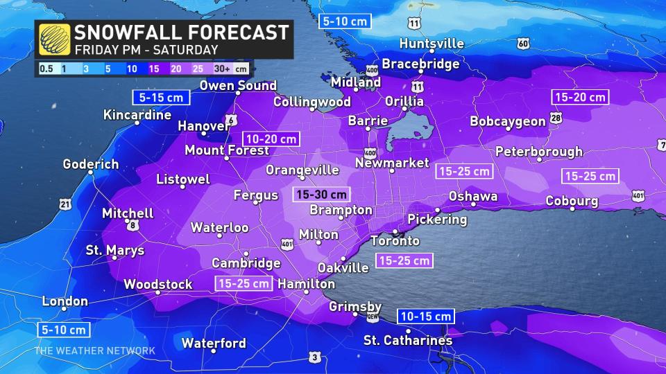
The system will produce a 15-25 cm blanket of heavy, wet snow across much of southern Ontario, with gusty winds likely leading to blizzard conditions at times. A few spots could see up to 30 cm of snow. Travel will be difficult and dangerous at the height of the storm, and tree damage and power outages are possible.
Visit our Complete Guide to Spring 2023 for an in-depth look at the Spring Forecast, tips to plan for it and much more!
A Texas low getting its act together over the southern Plains on Thursday night brought a risk for baseball size hail and strong tornadoes to portions of the southern United States, including the cities of Dallas and Memphis.
This dynamic and moisture-laden storm will trek toward the Great Lakes on Friday, pushing heavy precipitation into southern Ontario during the evening hours. The storm will last into the first half of Saturday, possibly bringing the season’s biggest snowfall totals to some parts of the region.
Heavy snow, low visibility rapidly sets in Friday night
Friday morning’s commute will likely unfold just fine. The latest model runs have trended the storm’s speed a bit slower, which could spare much of the Friday evening commute across the Greater Toronto Area (GTA).
MUST SEE: 'Common sense' driving tips to help steer through Canada's winter
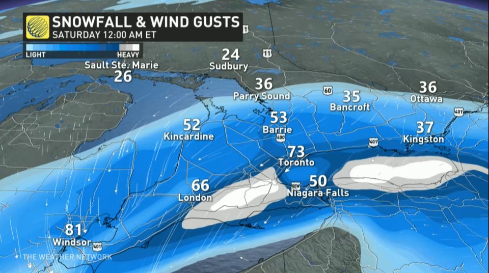
Conditions will rapidly deteriorate as night settles in, with the heaviest snowfall and gustiest winds arriving through the overnight hours. Winds could easily gust to 60-70+ km/h during the storm.
The combination of heavy snow and strong winds will lead to a period of blizzard conditions on Friday night, especially near the west end of Lake Ontario, including the city of Toronto. Travel will be difficult and dangerous at the height of the storm.
The bulk of the precipitation we’ll see from this system will fall as snow—a change from the region’s recent systems—but warmer temperatures in the southwest will make this mostly a rain event there, and marginal temperatures could force some mixing around the Niagara Peninsula.

By the end of the storm on Saturday morning, we’ll likely see a blanket of 15-25 cm of snow across much of southern Ontario, with up to 30 cm in spots. The greatest uncertainty is how much of the region will see a changeover to ice and rain. The highest risk for a changeover to a period of ice pellets and freezing rain will be for areas south and west of the GTA.
MUST WATCH: Why Ontario should pay attention to this incoming storm
Making a bad situation worse, temperatures hovering near the freezing mark will make this a heavy, wet snowfall.
Gusty winds and the weight of this wet snow on trees and power lines will lead to an increased risk for power outages throughout the area. Remain mindful of trees and tree branches that could fall during the storm.
MUST SEE: Staying safe during a power outage
Shovelling up to 30 cm of snow is a chore on its own, but the sheer weight of the snow will increase the challenge of the post-storm cleanup. Pay extra mind to the physical stress of shovelling heavy snow, taking care to stretch beforehand, shovel with safety in mind, and stop for frequent breaks.
Folks heading out to clean up on Saturday will encounter light snow lingering through the first half of Saturday as the system pushes east into New England.
Beyond this storm, temperatures will warm up a touch heading into the first weekend of March. Daytime highs approaching the mid-single digits will aid with cleanup efforts, though black ice will be a concern each night as lows drop below freezing.
WATCH: Do you know about the 4-4-4 rule regarding blizzards?
LOOK AHEAD: Great ski conditions likely for March Break
Below-seasonal temperatures will return for the second half of next week and through the following week, which is March Break for most schools. At this point, we don't expect frigid weather, but not very spring-like either, with temperatures a few degrees colder than seasonal.
Southern Ontario ski areas should be in great shape for March Break.
Today may be the first day of #MeteorologicalSpring, but this year, astronomical spring begins on March 20. ☔❄️ Let's debate: Do you consider March to be a winter, or spring month? #TWNPoll #SpringForecast
Today may be the first day of The Weather Network on Twitter: "Today may be the first day of #MeteorologicalSpring, but this year, astronomical spring begins on March 20. ☔❄️ Let's debate: Do you consider March to be a winter, or spring month? #TWNPoll #SpringForecast / Twitter", but this year, astronomical spring begins on March 20. ☔❄️
Let's debate: Do you consider March to be a winter, or spring month? The Weather Network on Twitter: "Today may be the first day of #MeteorologicalSpring, but this year, astronomical spring begins on March 20. ☔❄️ Let's debate: Do you consider March to be a winter, or spring month? #TWNPoll #SpringForecast / Twitter" The Weather Network on Twitter: "Today may be the first day of #MeteorologicalSpring, but this year, astronomical spring begins on March 20. ☔❄️ Let's debate: Do you consider March to be a winter, or spring month? #TWNPoll #SpringForecast / Twitter"— The Weather Network (@weathernetwork) The Weather Network on Twitter: "Today may be the first day of #MeteorologicalSpring, but this year, astronomical spring begins on March 20. ☔❄️ Let's debate: Do you consider March to be a winter, or spring month? #TWNPoll #SpringForecast / Twitter"
Stay tuned to The Weather Network for the latest on this major storm eyeing southern Ontario.

