Blizzards to make for near-impossible overnight travel in Ontario
Travel will remain difficult if not impossible across much of southern Ontario overnight Friday into Saturday as a juggernaut of a winter storm hammers the Great Lakes.
The sun set on Friday evening with blizzard conditions plaguing communities from Windsor to Kingston, shuttering dozens of major roads across the region and leaving tens of thousands of homes and businesses without power as temperatures dropped.
Avoid all non-essential travel until conditions improve. This is the kind of storm that can and will leave motorists stranded on the road, which is no small ordeal when it’s this cold and windy.
Resources:
According to Hydro One, the storm knocked out power to more than 70,000 customers during the day Friday. That number ticked up from 50,000 around sunset, and it’ll continue to fluctuate as high winds persist overnight.
Heavy snowfall and whiteout conditions have led to widespread road closures across southern Ontario. All roads in Dufferin County were closed as of 2:25 p.m. on Friday, and all roads in Bruce County closed later the same evening. Authorities shuttered sections of Highways 401 and 402 on Friday afternoon due to impassable conditions and multiple collisions.
“Fortunately, no serious injuries have been associated with any of the multi-vehicle collisions along the 401/402 corridor,” the Ontario Provincial Police (OPP) tweeted on Friday.
You don't want to be caught in this. #MiddlesexOPP media officer Cst. Jeff Hare says the 401/402 corridor is one of the worst traffic scenes he's ever seen. Today is a good day to stay home and stay safe. For road closure information, check @OPP_COMM_WR or @511ONWest. ^dr pic.twitter.com/2iKGIpkN2u
You don't want to be caught in this. OPP West Region on Twitter: "You don't want to be caught in this. #MiddlesexOPP media officer Cst. Jeff Hare says the 401/402 corridor is one of the worst traffic scenes he's ever seen. Today is a good day to stay home and stay safe. For road closure information, check @OPP_COMM_WR or @511ONWest. ^dr pic.twitter.com/2iKGIpkN2u / Twitter" media officer Cst. Jeff Hare says the 401/402 corridor is one of the worst traffic scenes he's ever seen. Today is a good day to stay home and stay safe. For road closure information, check OPP West Region on Twitter: "You don't want to be caught in this. #MiddlesexOPP media officer Cst. Jeff Hare says the 401/402 corridor is one of the worst traffic scenes he's ever seen. Today is a good day to stay home and stay safe. For road closure information, check @OPP_COMM_WR or @511ONWest. ^dr pic.twitter.com/2iKGIpkN2u / Twitter" or OPP West Region on Twitter: "You don't want to be caught in this. #MiddlesexOPP media officer Cst. Jeff Hare says the 401/402 corridor is one of the worst traffic scenes he's ever seen. Today is a good day to stay home and stay safe. For road closure information, check @OPP_COMM_WR or @511ONWest. ^dr pic.twitter.com/2iKGIpkN2u / Twitter". ^dr OPP West Region on Twitter: "You don't want to be caught in this. #MiddlesexOPP media officer Cst. Jeff Hare says the 401/402 corridor is one of the worst traffic scenes he's ever seen. Today is a good day to stay home and stay safe. For road closure information, check @OPP_COMM_WR or @511ONWest. ^dr pic.twitter.com/2iKGIpkN2u / Twitter"
WestJet cancelled all flights out of Pearson on Friday as well, stating the weather situation across Canada is "unlike anything we've experienced."
Widespread blizzard warnings remain in effect across southern Ontario as the storm rages across the region. These warnings blanket southwestern Ontario and many of the lakeshores, including the communities of Hamilton, St. Catharines, London, Windsor, Goderich, Kincardine, Orillia, and Kingston.
Communities under this warning could experience “crippling blizzard conditions,” according to Environment and Climate Change Canada (ECCC).
Elsewhere, winter storm warnings cover the rest of southern and eastern Ontario into the start of the weekend, alerting residents of the risk for heavy snow and high winds creating reduced or zero visibility that will make travel dangerous for the duration of the storm.
Yes, there's a gas station across the street. In Ft Erie now. @weathernetwork #ONStorm pic.twitter.com/EHInSWP8VT
Yes, there’s a gas station across the street. In Ft Erie now. Mark Robinson on Twitter: "Yes, there's a gas station across the street. In Ft Erie now. @weathernetwork #ONStorm pic.twitter.com/EHInSWP8VT / Twitter" Mark Robinson on Twitter: "Yes, there's a gas station across the street. In Ft Erie now. @weathernetwork #ONStorm pic.twitter.com/EHInSWP8VT / Twitter" Mark Robinson on Twitter: "Yes, there's a gas station across the street. In Ft Erie now. @weathernetwork #ONStorm pic.twitter.com/EHInSWP8VT / Twitter"
— Mark Robinson (@StormhunterTWN) Mark Robinson on Twitter: "Yes, there's a gas station across the street. In Ft Erie now. @weathernetwork #ONStorm pic.twitter.com/EHInSWP8VT / Twitter"
MUST SEE: Holiday havoc: Vast, 3,000-km-sized storm puts travel plans in peril
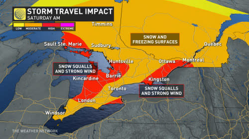
Through Saturday morning: Travel havoc as blizzards continue
Conditions steadily deteriorated into the day Friday as this mammoth storm system wrapped up and intensified over the Great Lakes region.
Friday’s high temperature occurred early in the morning before the legendary push of Arctic air crossed the border and swept over Ontario. Windsor’s temperature dropped from 1°C at 1:00 a.m. down to -17°C with a wind chill value of -32 by 1:00 p.m.
Frigid temperatures and dangerously cold wind chills will continue into the long holiday weekend.
While the Greater Toronto Area (GTA) won’t have to deal with major snow accumulations from this system, anyone driving outside of the GTA in any direction will likely have to deal with dangerous conditions into Saturday. It’s critically important to be aware of what’s happening throughout the region and alter travel plans accordingly.
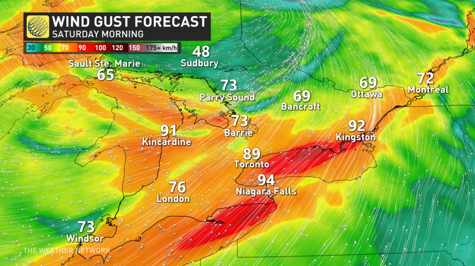
Winds will continue to howl overnight Friday into Saturday.
Lakeshore communities along Huron, Erie, and Ontario could see gusts exceed 90 km/h, with widespread gusts of 70-80+ km/h across the rest of southern Ontario.
WATCH: Wicked winds rip through Ontario and Quebec as blizzard hits
In addition to the risk for power outages and damage, the intense winds are creating blizzard conditions and whiteouts across areas dealing with snowfall.
"Remember, it does not take much accumulation in combination with very strong winds for whiteout conditions to develop," says Environment and Climate Change Canada (ECCC) in the winter storm warning. "Consider postponing non-essential travel until conditions improve."
Travel along the 401 corridor east of Toronto and towards Kingston is highly discouraged.
Can't say this strongly enough - this afternoon and evening will be one of the worst driving situations I've ever seen for the 401 east of Toronto through Kingston. Anyone on the road should be prepared to be stranded by blizzard conditions. #ONStorm pic.twitter.com/ViYsqYG5UW
Can’t say this strongly enough - this afternoon and evening will be one of the worst driving situations I’ve ever seen for the 401 east of Toronto through Kingston. Anyone on the road should be prepared to be stranded by blizzard conditions. Chris Scott on Twitter: "Can't say this strongly enough - this afternoon and evening will be one of the worst driving situations I've ever seen for the 401 east of Toronto through Kingston. Anyone on the road should be prepared to be stranded by blizzard conditions. #ONStorm pic.twitter.com/ViYsqYG5UW / Twitter" Chris Scott on Twitter: "Can't say this strongly enough - this afternoon and evening will be one of the worst driving situations I've ever seen for the 401 east of Toronto through Kingston. Anyone on the road should be prepared to be stranded by blizzard conditions. #ONStorm pic.twitter.com/ViYsqYG5UW / Twitter"
Visibility can change rapidly during high winds and heavy snowfall.
Powerful southwesterly winds across the lakes will also lead to large waves, as well as a risk for ice shoves and ice buildup along the shoreline.
Saturday (Christmas Eve): Intense snow squalls set up
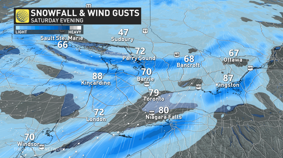
Blustery winds behind the storm will give rise to intense lake-enhanced snow squalls off Lake Huron, Georgian Bay, and Lakes Erie and Ontario. Road closures are likely as heavy snowfall combines with powerful winds up to 100 km/h to lead to widespread whiteout conditions.
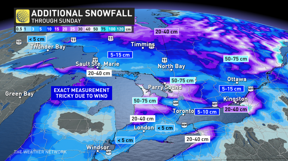
Regions caught beneath the Huron and Georgian Bay snow squalls could see 50-75 cm of snow by the end of the weekend, with totals of 20-40 cm possible away from the lakes as the bands meander inland. Exact measurements will be tricky due snow blowing and drifting in the high winds.
Sunday (Christmas Day): Conditions gradually improve as system pushes east
Christmas Day itself is looking much better across the bulk of Ontario’s population centres as the storm lifts north and east out of the province.
Snow squalls will remain a threat for the snowbelts and some communities near Lakes Erie and Ontario. This lake-effect snow could meander and push through southern Ontario at times through the day Sunday.
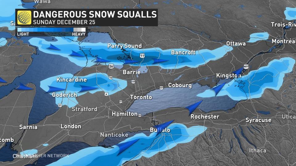
Check the forecast if you plan to travel on Christmas Day to see if there is any chance of encountering snow squalls on your route. The squalls will continue through the day, slowly winding down into Boxing Day on Monday.
WATCH: Your questions about holiday storm answered by our meteorologists
Check back for the latest on the forecast across southern Ontario.
ICYMI: Our Chief Meteorologist @ChrisScottWx along with meteorologists @ThatMetGirl @matt_grinter and weather expert @KMacTWN answer your questions about the incoming #ONStorm #QCStorm 🎙❄ https://t.co/nzsF0L6jeo
ICYMI: Our Chief Meteorologist The Weather Network on Twitter: "ICYMI: Our Chief Meteorologist @ChrisScottWx along with meteorologists @ThatMetGirl @matt_grinter and weather expert @KMacTWN answer your questions about the incoming #ONStorm #QCStorm 🎙❄ https://t.co/nzsF0L6jeo / Twitter" along with meteorologists The Weather Network on Twitter: "ICYMI: Our Chief Meteorologist @ChrisScottWx along with meteorologists @ThatMetGirl @matt_grinter and weather expert @KMacTWN answer your questions about the incoming #ONStorm #QCStorm 🎙❄ https://t.co/nzsF0L6jeo / Twitter" The Weather Network on Twitter: "ICYMI: Our Chief Meteorologist @ChrisScottWx along with meteorologists @ThatMetGirl @matt_grinter and weather expert @KMacTWN answer your questions about the incoming #ONStorm #QCStorm 🎙❄ https://t.co/nzsF0L6jeo / Twitter" and weather expert The Weather Network on Twitter: "ICYMI: Our Chief Meteorologist @ChrisScottWx along with meteorologists @ThatMetGirl @matt_grinter and weather expert @KMacTWN answer your questions about the incoming #ONStorm #QCStorm 🎙❄ https://t.co/nzsF0L6jeo / Twitter" answer your questions about the incoming The Weather Network on Twitter: "ICYMI: Our Chief Meteorologist @ChrisScottWx along with meteorologists @ThatMetGirl @matt_grinter and weather expert @KMacTWN answer your questions about the incoming #ONStorm #QCStorm 🎙❄ https://t.co/nzsF0L6jeo / Twitter" The Weather Network on Twitter: "ICYMI: Our Chief Meteorologist @ChrisScottWx along with meteorologists @ThatMetGirl @matt_grinter and weather expert @KMacTWN answer your questions about the incoming #ONStorm #QCStorm 🎙❄ https://t.co/nzsF0L6jeo / Twitter" 🎙❄ The Weather Network on Twitter: "ICYMI: Our Chief Meteorologist @ChrisScottWx along with meteorologists @ThatMetGirl @matt_grinter and weather expert @KMacTWN answer your questions about the incoming #ONStorm #QCStorm 🎙❄ https://t.co/nzsF0L6jeo / Twitter"
— The Weather Network (@weathernetwork) The Weather Network on Twitter: "ICYMI: Our Chief Meteorologist @ChrisScottWx along with meteorologists @ThatMetGirl @matt_grinter and weather expert @KMacTWN answer your questions about the incoming #ONStorm #QCStorm 🎙❄ https://t.co/nzsF0L6jeo / Twitter"
---

