Blizzards, tornadoes and a hurricane: We lived through SoCal's year of weird weather
How to describe the weather in Southern California this year?
All that rain? That snow? Spring floods and a summertime hurricane?
“Distinctly different,” says Daniel Swain, a UCLA climate scientist who chooses his words carefully.
Maybe it was more than different. As the rest of the planet followed a predictable if worrisome pattern, setting records for heat and rising sea levels, Southern California didn’t know which way to turn. It was downright weird.
Let the numbers tell the story.
For the first time, the National Weather Service issued a tropical storm warning for the Southern California region. Though Hurricane Hilary lost some ferocity and was downgraded to a tropical storm by landfall in mid-August, it was undeniably historic.
More than 3 inches of rain fell in Burbank and more than three times that much soaked the mountains, obliterating a slew of records that dated back to 1877 when the weather service began tracking data.
There were mudslides, flash floods and widespread power outages. Still, we may have gotten lucky.
“The flooding wasn’t catastrophic,” Swain says. “It could have been worse.”
Read more: Full coverage of Hilary
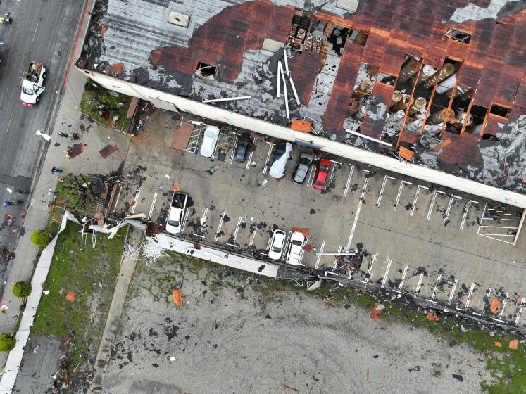
Tornadoes aren’t unprecedented in Southern California — they crop up from time to time. This year, we got two violent twisters in two days.
It was late March and a powerful storm front was dumping record rainfall on Los Angeles. In other parts of the state, major rivers overflowed their banks, flooding communities and farmlands.
The first tornado touched down in Carpinteria, lasting about two minutes and damaging 25 units in a mobile home park. The following afternoon, the strongest twister to hit L.A. County in four decades ripped through Montebello with 110-mph winds that left 17 buildings damaged, 11 of them badly enough to be red-tagged.
“When it’s happening, you don’t know what to do,” says a woman who watched people running for cover outside her Montebello workplace, “because it’s never happened here before.”
Read more: Strongest tornado in L.A. County in 40 years hit 110 mile-per-hour winds
Each winter, a few dozen atmospheric rivers, or ARs, drift over California. Like rivers flowing across the sky, these streams of water vapor stretch for thousands of miles, carrying moisture from the tropics — hence the nickname “pineapple express.”
This year was extraordinary because there were nine in the three weeks between Christmas and mid-January, arriving one after another like planes on approach to LAX. Six were rated at least a 3 out of 5 based on strength and duration.
“That number of strong ARs is what we might get in a whole year,” says Marty Ralph, a research meteorologist at UC San Diego’s Scripps Institution of Oceanography. “We had a lot of extra action.”
Downtown L.A. received more than double its average rainfall for those few weeks when compared with previous years.
The average temperature in downtown L.A. for September was 72 degrees — 5 degrees cooler than last year.
Sure, there were hot stretches in places such as Woodland Hills and Lancaster, but overall summer temperatures were below normal through much of Southern California. Credit all those low-pressure systems, the overcast days and Hilary taking a bite out of August.
In San Diego, Ralph could feel the difference.
“Coldest summer I can remember,” he says. “I mean, it was cloudy and chilly.”
The blizzard that hit Southern California in late February started in the Gulf of Alaska, but along the way it tapped into that tropical AR system, gathering extra moisture into its icy clutches.
Snow fell as low as 1,000 feet, painting local mountains a brilliant white and offering the once-in-a-lifetime chance to go backcountry skiing within Los Angeles city limits.
Big Bear and neighboring communities got buried under as much as 12 feet, blocking roads and causing San Bernardino County to declare a state of emergency. As Swain says: “How often do you see people trapped in their homes due to snowfall? That is not common in Southern California.”
Thirteen people died during the back-to-back storms and their aftermath. Though county officials ruled only one of those deaths to be weather-related, residents have questioned the finding.
That might seem like a big number, but the 319,956 acres of land burned in California wildfires as of last week are even less than 2022's unusual low of 363,939. They are but a fraction of 4.3 million scorched in 2020 and 2.5 million in 2021.
Though unusual rainfall led to a thicker carpeting of grasses, brush and trees, the moisture content and cooler temperatures hampered ignition. With fewer blazes to fight, state and local crews had more time to work on fuel reduction.
“We didn’t have those sweltering, scorching heat conditions,” Cal Fire spokesman Capt. Chris Bruno says. “We absolutely took advantage of the opportunity.”
There are 21 days until 2024. Is this year a harbinger for stranger things to come?
Long-range forecasts are risky, especially months down the road, but even a cautious Swain says: “I think that’s a plausible line of inquiry.”
This story originally appeared in Los Angeles Times.

