Snowy, icy storm knocking on Ontario’s door to start the weekend
A lively system that spawned a tornado in Los Angeles earlier this week will set its sights on the Great Lakes this weekend, bringing a threat for more snowy and icy conditions to Ontario on Saturday.
This storm will have an early-spring flavour with a taste of winter thrown in the mix. Blustery conditions will accompany a round of rain, snow, and ice throughout the province. Precipitation type will heavily depend on temperature and location, a common feature for storms this time of year.
RELATED: Damage, injuries after Los Angeles area’s strongest tornado in 40 years
A strong and active storm track continues to roll right over Ontario, bringing the opportunity for additional unsettled weather into the final weekend of March.
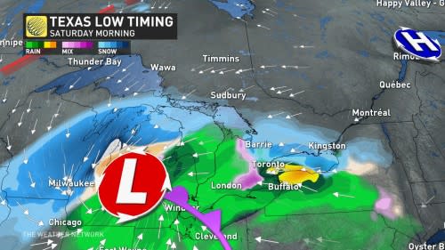
This next system—the second in the past few days—will arrive during the pre-dawn hours on Saturday. The centre of the low will track toward Timmins, putting much of southern Ontario in that messy zone where all precipitation types are possible for the duration of the storm.
Saturday morning will see a chilly easterly wind pick up as the precipitation begins, with gusts of 50 km/h or higher making for raw, glum conditions that will encourage sleeping in or tending the virtual crops in your favourite video game.
Winds will shift around to the south and southwest through Saturday afternoon and into the evening, with gusts increasing to over 60 km/h across the Greater Toronto Area (GTA). Southern Niagara, southwestern Ontario, and along the shores of Lake Huron will see the strongest gusts between 70-80 km/h Saturday evening and overnight.
Gusty winds and dreary rain aren’t the only issues we’ll see across the GTA on Saturday morning.
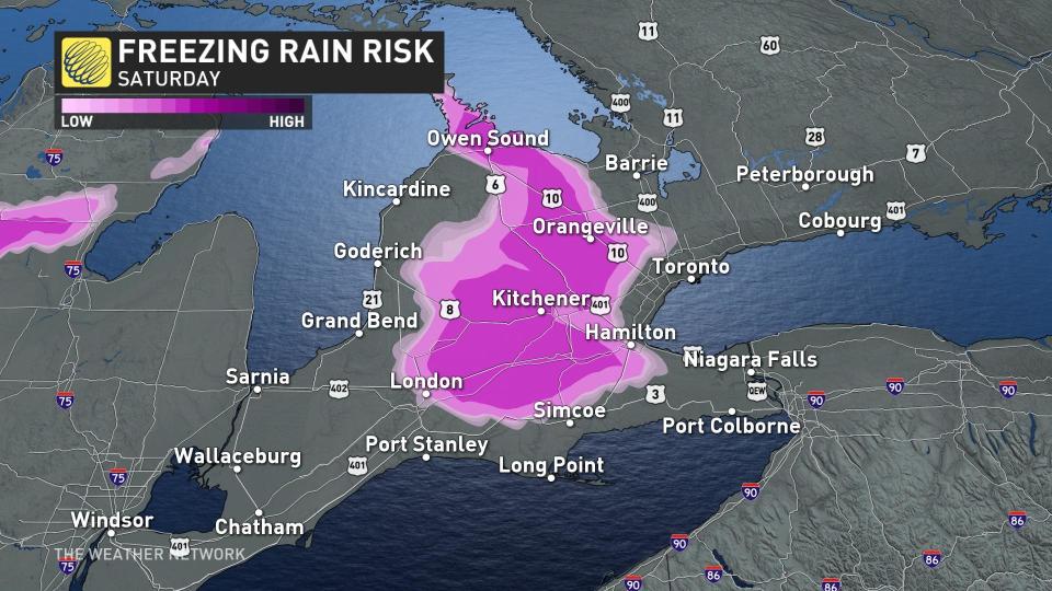
Cooler temperatures on Saturday morning will force a changeover to freezing rain or ice pellets across higher terrain north of the 401 and into the Niagara Escarpment. Slick conditions are possible here before rising temperatures bring a changeover to straight rain later in the morning.
Across the GTA, between 5-15 mm of rain is expected, with up to 25 mm possible from Hamilton to Niagara and into the southwest. For the Ottawa area, less than 5 mm is expected.
Through cottage country and into the Ottawa Valley, precipitation will start as snow through Saturday morning, then gradually change to light rain during the afternoon.
This will be a quick-moving system, so cooler air will filter back in behind the low by Saturday evening. Rain will change over to snow once again from west to east across the southwest and the GTA. Moisture will clear out as the storm pulls east by Saturday night.
MUST SEE: Spring is here: When should you take your winter tires off?
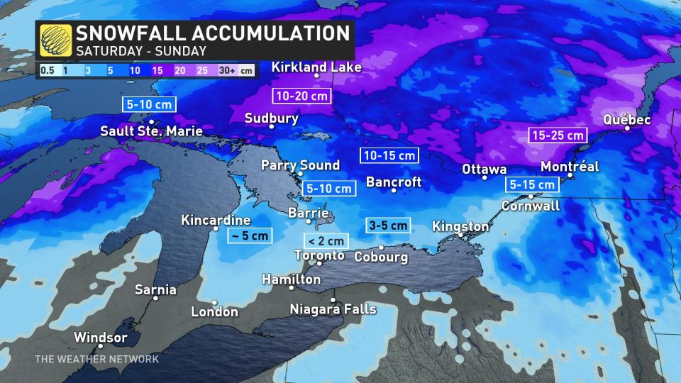
Modest and relatively manageable snowfall totals are in the forecast. South of Highway 401, not much is expected in terms of snow accumulation, but north of the area, 2-4 cm of snow could fall.
Over higher terrain, northwest of Toronto and into cottage country, 5-10 cm of snow is forecast, with 2-5 cm likely in the Ottawa area. Use caution while travelling, however, as even a small coating of snow can make roads slick.
Looking ahead, another storm is expected to track across southern Ontario just in time to close out March.
Changeable temperatures are expected for the final days of March through early April as well, with no sustained warm weather in sight.
Stay tuned to The Weather Network as we continue to update this week's forecast for Ontario.

