Break in Pacific storms for California to aid mudslide, damage cleanup
A much-needed break from the storms touting inches of rain and feet of snow will begin in some areas on Friday and expand to much of the Pacific coast by next week.
The storms have been deadly, disruptive and beneficial at the same time. Mudslides and flash flooding have occurred, while rain has filled reservoirs and streams and banked deep snow in the Sierra Nevada and Cascades for use as water this coming summer.
The upcoming dry weather will allow streams to recede to within their banks and cleanup to accelerate after mudslides and damage. The dry weather will also give travelers a break from wintry conditions over the mountains, while at the same time, ski resorts can expect business to be booming.
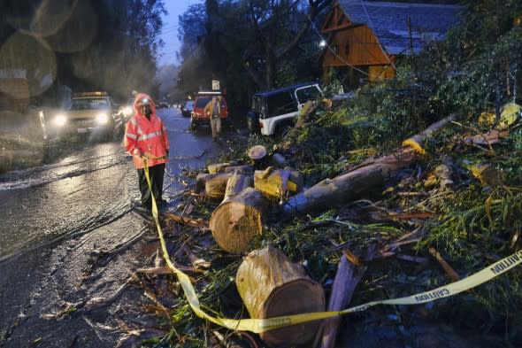
Department of Water and Power employees work in the pouring rain to clear a fallen tree from a road in the Hollywood hills in Los Angeles, Thursday, Jan. 17, 2019. The latest in a series of Pacific Ocean storms pounded California with rain and snow Thursday, prompting officials to put communities on alert for mudslides and flooding and making travel treacherous. (AP Photo/Richard Vogel)
Dry weather will overspread Southern California on Friday and may last through next week and perhaps the end of the month.
Farther north, areas from Northern California to Washington are likely to have to wait until next week for consistently dry weather.
A couple of storms will bring some rain, mountain snow and wind from Friday to Sunday.
There may continue to be weaker storms with rain and mountain snow showers in Washington into Wednesday.
While dry weather will return, some episodes of strong winds are forecast into next week over California.

"There may be a moderate Sundowner wind event during Friday night to Saturday," according to AccuWeather Meteorologist Maggie Samuhel.
Northerly winds of 25-45 mph are forecast.
"However, we don't expect a strong Santa Ana event to follow over the weekend," Samuhel said.
A moderate to strong Santa Ana seems likely early next week, however.
Northeasterly winds may become strong enough to knock over trees and cause problems for high profile vehicles in the traditionally windy spots during a Santa Ana, especially from Monday to Tuesday.
Trees may be more likely to topple due to the excessive rainfall and wet ground.
Gusts early next week over the passes and through the northeast-southwest orientated canyons may reach 60 mph.
"The main effect of the winds will be to dry out the landscape," Samuhel said. "But since we have gotten so much rain lately, we are not likely to have a big jump in the wildfire risk, at least not right away."
Join host Regina Miller as she examines Forensic Meteorology and the reconstruction of weather events for legal testimonies. Steve Wistar, AccuWeather's Forensic Meteorologist and Certified Consulting Meteorologist recalls prominent legal cases where winter weather played a key role in the verdicts.

