Brockton braces for potential Hurricane Lee impact: How to stay ahead of the storm
Hurricane Lee is expected to reach the coast of Maine, New Brunswick, or Nova Scotia in about four days, but the National Hurricane Center warns that the impacts of Lee will be far reaching due to its size.
"There is an increasing risk of wind, coastal flooding, and rain impacts from Lee in portions of New England beginning on Friday," the National Hurricane Center wrote in a tweet Wednesday morning.
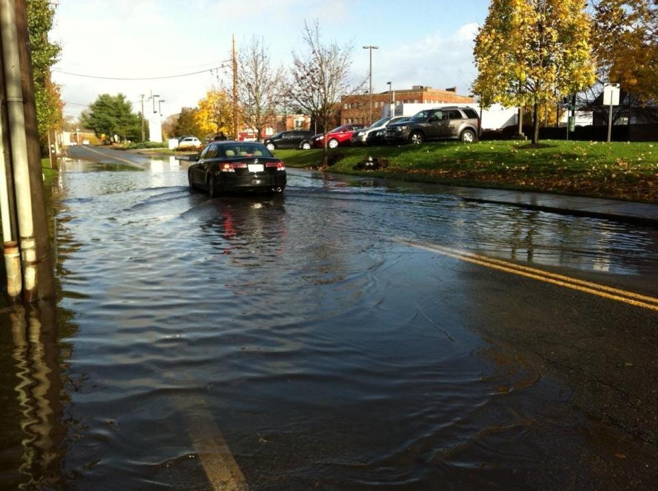
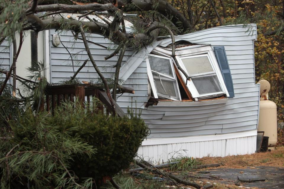
A look back at Hurricane Sandy: Winds from Sandy cause havoc across southeastern Mass.
Brockton and Plymouth are already under flood watches from the National Weather Service, until at least Thursday morning.
According to AccuWeather forecasters, the exact severity of wind, rain and flooding in New England will depend on the track and strength of Lee late this week and this weekend.
Here’s what to know ahead of time to keep you, your family and your property as safe as possible, according to the Massachusetts Emergency Management Agency (MEMA)’s hurricane safety tips.
Is Brockton in a hurricane evacuation zone?
According to MEMA, evacuation during a hurricane may become necessary when there is a risk of a storm surge. “The destructive power of storm surges and large battering waves is often the greatest threat to life and property,” the agency wrote on its website.
However, Brockton, Bridgewater, West Bridgewater, East Bridgewater, Stoughton, Easton and Raynham are not in a hurricane evacuation zone.
Coastal Plymouth is located in hurricane evacuation Zone A, meaning it's in an area of increased risk of flooding from storm surges.
What is the city of Brockton doing to prepare for Hurricane Lee?
As of Wednesday noontime, the Brockton Emergency Management Agency said it’s too early to tell what kind of preparation, if any, the city would undertake. The agency is slated to meet with the National Hurricane Center and MEMA at 3 p.m. Wednesday.

How can Brockton residents stay up to date on hurricane information?
Residents will automatically receive emergency alerts and weather warnings through their radio, television and cellphones with the nationwide Emergency Alert System (EAS) and Wireless Emergency Alerts (WEA). The National Oceanic and Atmospheric Administration (NOAA) weather radio also provides emergency weather alerts and warnings. Follow MEMA on Twitter and Facebook, and call 211 for non-emergency assistance in Massachusetts. For local information, follow the Brockton Emergency Management Agency on Twitter and Facebook.
How should I prepare for power outages?
MEMA recommends ensuring smoke and carbon monoxide detectors are working and have fresh batteries ahead of an impending hurricane. Charge all electronics and get in touch with your medical provider and utility companies ahead of this weekend if your life-supporting medical equipment relies on electricity. Call National Grid of Massachusetts (800-465-1212) to report power outages during the storm.
How should I prepare my home for Hurricane Lee?
Secure or bring in outdoor furniture, clear clogged rain gutters, turn off propane tanks if not in use, elevate items in your basement, and unplug sensitive electronic equipment in flood prone areas, MEMA writes. If damaging winds are expected, cover all windows with storm shutters or marine plywood.
What supplies do I need?
MEMA advises residents stock up on a three-day supply of water and food, a radio, a flashlight, extra batteries, a two-week supply of medication, personal hygiene items, important documents like identification cards and insurance policies, a first-aid kit, waterproof matches, area maps, extra cash, and extra supplies for pets or babies.
An emergency kit checklist can be found on MEMA’s website.
What hurricanes have hit Brockton in the past?
According to reporting by an Enterprise reporter, Brockton residents have been surviving hurricanes for hundreds of years.
Great Colonial Hurricane: Striking on Aug. 25, 1635, this was the first recorded intense hurricane striking New England. The highest winds have been estimated at Category 3 or greater, about 115-plus mph. The storm’s eye passed between Boston and Plymouth causing at least 46 casualties. A 20-foot tidal surge was reported in Boston, ruining farms.
Great New England Hurricane: This hurricane, which arrived on Sept. 21, 1938, has also been dubbed “The Long Island Express.” Without warning, it made landfall, as a Category 3, during high tide along Long Island, N.Y., and the Connecticut coast. The Blue Hill Observatory in Milton measured sustained winds of 121 mph, with gusts of 183 mph. Downtown Providence was devastated by a 20-foot storm surge. The destruction included 600 deaths and 1,700 injuries, and $400 million in damage, including 9,000 homes and businesses lost.

Hurricane Carol: This compact, but powerful Category 2 hurricane battered New England on Aug. 31, 1954, killing 68 and raking the region with 100 mph winds, gusts up to 135 mph. Carol caused more than $461 million in damage, destroying 4,000 homes, 3,500 cars and 3,000 boats. It was the most destructive storm to hit southern New England since 1938.

Hurricane Gloria: Hurricane Gloria, which struck on Sept. 27, 1985, was a powerful Category 4 storm with winds up to 145 mph. It caused severe beach erosion, wrecking many piers and coastal roads. The storm killed eight people, left more than 2 million without power, caused widespread flooding, $900 million in damage.
Hurricane Bob: On Aug. 19, 1991, Hurricane Bob made landfall near New Bedford and cut a path across southeastern Massachusetts. Peak winds were 125 mph on Cape Cod. More than 60 percent of southeastern Mass. and southeastern Rhode Island lost power and there were four different reports of tornados as Bob came ashore. The damage total for southern New England was set at $1 billion.
This article originally appeared on The Enterprise: Brockton, how to prepare for Hurricane Lee, historic hurricanes in MA

