What is BRT and why is OKC spending $61 million on it? Here's what to know
Local officials, city engineers and project consultants for Oklahoma City's MAPS 4 are asking the public for feedback on the $61 million-budgeted "Bus Rapid Transit" lines planned for the south side and northeast Oklahoma City.
The city held public meetings and "open house" events last week, asking residents who stopped by how the upcoming BRT additions could better serve the affected communities in the service areas. Similar events are scheduled throughout the month.
"This is really just the first step," said Luke Schmidt, a traffic engineer with Kimley-Horn and Associates, the consulting firm working on behalf of MAPS 4.
What is Bus Rapid Transit?
Bus Rapid Transit (BRT) is a bus-based transportation system meant to "deliver fast, comfortable, and cost-effective services at metro-level capacities," according to the U.S. Department of Transportation website.
BRT routes are designed to feature high-frequency service with fewer stops, enhanced and specialized bus stations, and dedicated lanes similar to the city's EMBARK streetcar.
BRT services expanded throughout the country the past two decades as authorities attempted to find alternatives to fight rising traffic congestion. One major advantage of BRT is that, unlike most other bus services, it can avoid delays during high travel times.
Currently, Kimley-Horn consultants and engineers are weighing four design options that could be implemented on the BRT routes:
Mixed-flow traffic lanes
Curbside transit lanes
Center-running transit lane
Highway Dedicated Guideway
More:A fast ride between downtown OKC and Tinker eyed as part of Regional Transit Authority
What parts of Oklahoma City will access the new BRT?
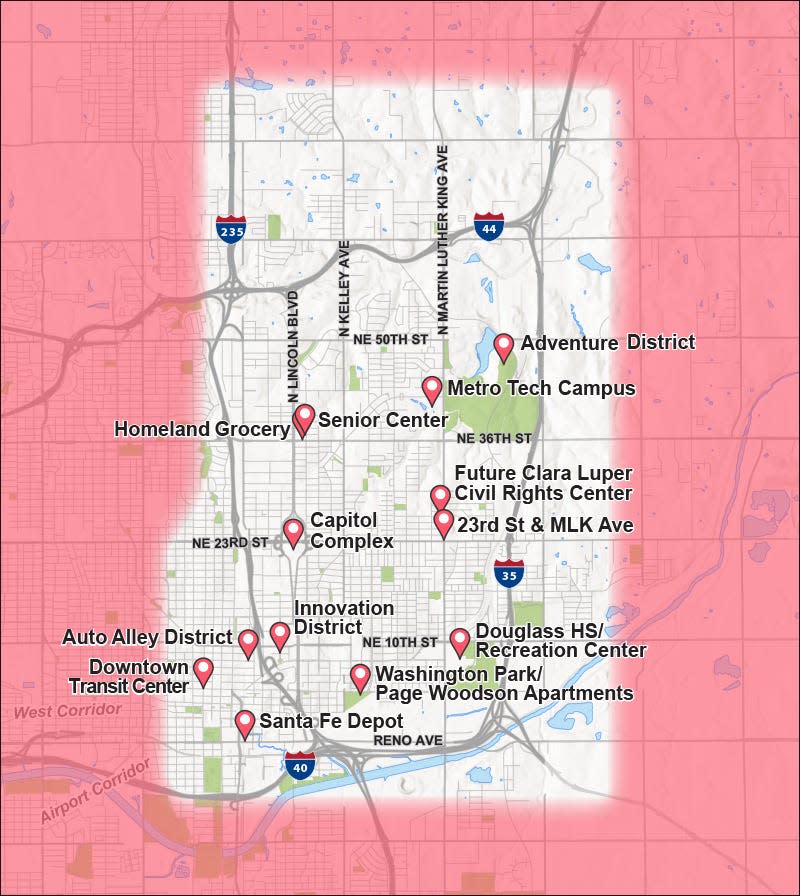
The planned service areas for the latest BRT expansion include both a "Northeast Corridor" and a "South Corridor" in parts of the Oklahoma City metro area.
The 30-square-mile study area for the Northeast Corridor encompasses major metro-area locations like:
The Adventure District
The Automobile Alley District
The Capitol Complex
The upcoming Clara Luper Civil Rights Center
The Downtown Transit Center
Douglass High School and its Recreation Center
The Homeland grocery store at NE 36 and Lincoln, and its soon-to-open neighboring Senior Center
Innovation District
Metro Tech Campus
Santa Fe Depot
Washington Park
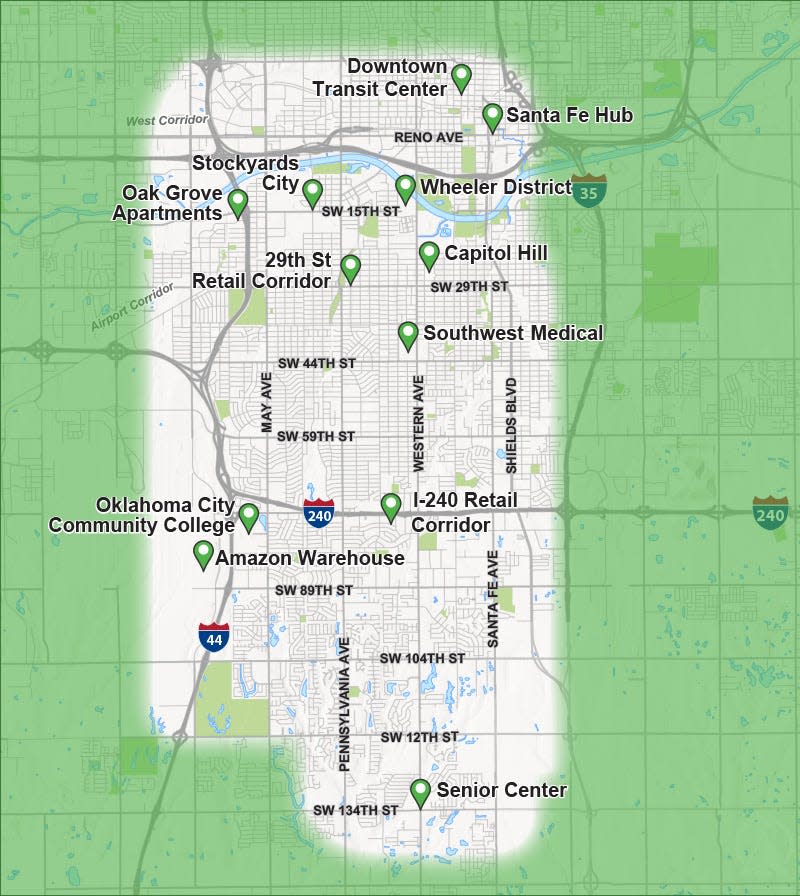
The 50-square-mile study area for the planned South Corridor includes key Oklahoma City sites like:
Amazon's Fulfillment Center Warehouse
Capitol Hill
Downtown Transit Center
Interstate 240 retail plazas
Integris Health Southwest Medical Center
Oak Grove Apartments
Oklahoma City Community College
Santa Fe Hub
Stockyards City
29th Street Retail corridor
The Wheeler District
Schmidt said data from the U.S. Census Bureau indicates that nearly 200,000 people live along the planned "South Corridor," and 55,000 people reside around the planned "Northeast Corridor" for the BRT.
The northeast area hosts about 100,000 jobs, Schmidt said, with the state government and the University of Oklahoma's medical facilities serving as major employers in the area. Similarly, the south OKC area hosts 100,000 jobs, as well, with Integris Health and Oklahoma City Community College providing many of them.
"The actual demographic data is one tool that we're looking at to determine optimal corridors," Schmidt said. "But we're also talking to the public to try to understand what the key destinations are that we need to get to. Where's your neighborhood? Where's your community? Where do you go to school? Entertainment, recreation? So a lot of the feedback will help us with that."
More:Free parking in Oklahoma City's Midtown and Automobile Alley may soon be ending
Where can residents go to submit comment on new BRT developments?
Community members are invited to voice their concerns and considerations about the BRT project through public meetings, pop-up events and interactive surveys.
One for the "South Corridor" is set for 6 to 8 p.m. Wednesday at the Southwest Oklahoma City Public Library, 2201 SW 134.
Another "open house" session is set for the "Northeast Corridor" from 5:30 to 7:30 p.m. Feb. 22 at Metro Technology Centers' Springlake Campus, 1900 Springlake Drive.
Residents also can answer questions through a 5-minute online survey at MAPS4BRT.com.
More:The nation's ailing bus and rail systems have a D- rating. Can Biden's infrastructure plan fix them?
When will the BRT line for northwest OKC launch?
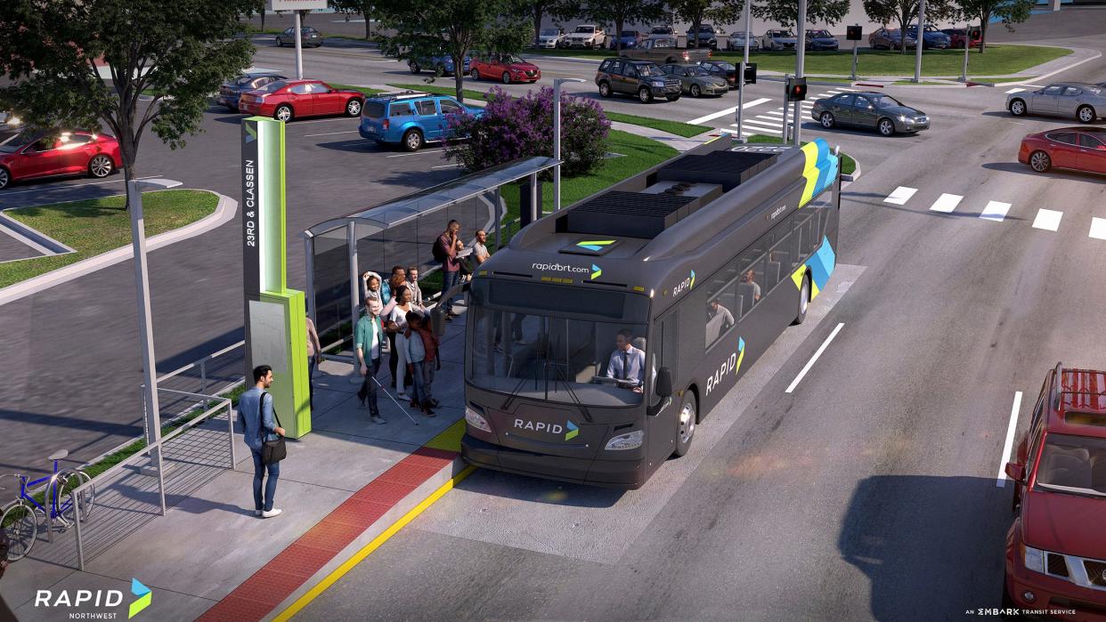
A BRT system line for northwest Oklahoma City is currently in construction and set to start running during autumn of this year. The northwest corridor line will connect downtown Oklahoma City and the Lake Hefner area, servicing medical centers, commercial areas and residents along Classen Boulevard and Northwest Expressway.
According to EMBARK, more than 20% of the region's jobs are located within half a mile of the northwest BRT system, with the potential to reach 40,000 residents and 91,000 local jobs.
The upcoming northwest BRT line provides an example of what the potential northeast and south corridor lines could physically look like. The northwest line is nearly 10 miles each way, featuring nine buses, 30 platform stops and priority traffic signals for 38 intersections. The line was designed to connect with the city's larger fixed-route bus network — specifically routes 005, 007, 008, 010, and 023 — EMBARK's streetcar and Spokies bike share program.
Enhanced station and passenger amenities for the northwest BRT line include:
Benches
Bike racks
Handrails
Level boarding features
Pylon signs with wayfinding
Real-time arrival display
Ticket kiosk
Trash receptacles
Cody Boyd, community engagement officer for EMBARK, said the city plans to connect the northwest line with the planned northeast and south corridor lines, but is still considering exactly where. "A logical point of connection," he said, might be the downtown Transit Center, which provides access to already-existing bus routes and the streetcar.
This article originally appeared on Oklahoman: Engineers seek feedback for rapid bus plans in northeast, south OKC

