Hurricane Norma to make landfall in Mexico, may eventually spread rain into US


The newest hurricane of the season in the East Pacific has developed, and it has rapidly intensified into the next major hurricane. Not only is the system likely to impact Mexico, but some of its moisture and energy will also eventually fuel rainfall across drought-stricken parts of the United States.
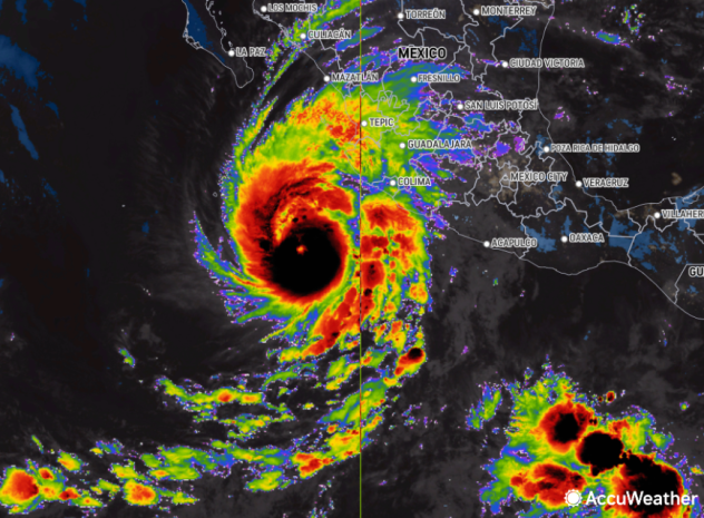
Tropical Storm Norma took shape on Tuesday afternoon and 24 hours later intensified into Hurricane Norma several hundred miles off the coast of Mexico over the Pacific Ocean. Maximum sustained winds spiked from 80 mph Wednesday afternoon to 120 mph late Wednesday night by which time it was moving to the north at 6 mph. Because of the likelihood that the system would become a hurricane and then swing back toward land, AccuWeather meteorologists began to refer to this system as a tropical rainstorm to raise public awareness of the risk to lives and property earlier this week.
 |
This image of the eastern Pacific Ocean shows Norma, as a major hurricane, on Thursday, Oct. 19, 2023. (AccuWeather Enhanced RealVue™ Satellite) |
Norma has rapidly intensified since Tuesday afternoon when winds were near 40 mph. The official threshold for rapid intensification is an increase of 35 or greater within a 24-hour period. AccuWeather meteorologists are projecting Norma to continue to rapidly strengthen and reach Category 4 hurricane strength on the Saffir-Simpson Hurricane Wind Scale with 130-156 mph winds on Thursday.
 |
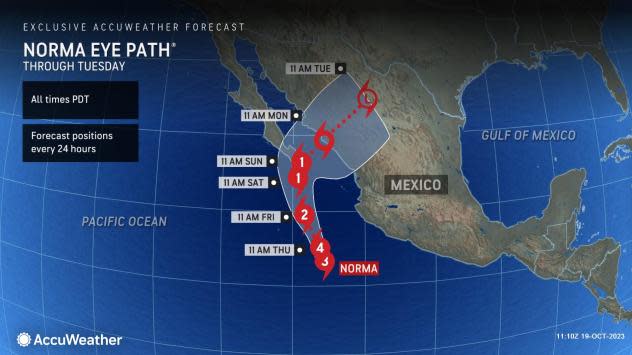
Initially, Norma may track toward the west or north for a time. However, steering breezes will eventually direct the system to the northeast and back toward the western coast of Mexico, perhaps as a potent hurricane.
Norma will likely begin to turn toward the northeast this weekend, eventually reaching landfall early next week along the central west coast of Mexico.
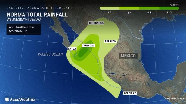
The storm is projected to roll inland in the zone from Mazatlán to Culiacán, Mexico, on Monday. However, the system may pass near the tip of the Baja Peninsula this weekend.
 |
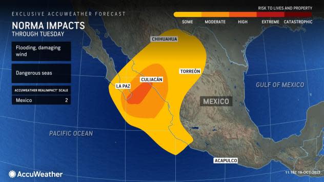
AccuWeather meteorologists have rated Hurricane Norma as "2" on the AccuWeather RealImpact™ Scale for Hurricanes, which is a six-point scale ranging from "less than one" and 1 to 5. There is the likelihood of heavy rain, which could lead to incidents of life-threatening flash flooding, mudslides and washouts, even though the system will weaken from peak status prior to reaching the shore.
The last tropical system to strike Mexico did so as a Category 4 hurricane on the Saffir-Simpson Hurricane Wind Scale. Major Hurricane Lidia made landfall just to the south of Puerto Vallarta, Mexico, with maximum sustained winds of 140 mph.
Have the app? Unlock AccuWeather Alerts™ with Premium+
Along with the likelihood of torrential rain, flooding and mudslides near the point of landfall, heavy rain associated with Norma will be wrung out over the mountains across the interior, where additional flash flooding is possible. There is the likelihood of a broad zone where 4-8 inches of rain will fall with locally higher amounts. The AccuWeather Local StormMax™ rainfall for Norma is 17 inches.
 |
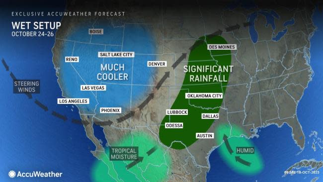
AccuWeather meteorologists believe that some moisture and/or energy from Norma will survive the trip over the mountains in northern Mexico and then reach the U.S.
"A dip in the jet stream that will develop in the western U.S. next week will help to scoop up the energy and moisture from the tropical system over the South Central states," AccuWeather Lead Long-Range Meteorologist Paul Pastelok said.
 |
There may be a gap in the rainfall triggered across Mexico and the U.S. as it may take some time for the jet stream dip to re-energize the system.
"At this time, the heaviest rain is likely to track across the northwestern part of Texas and the southwestern part of New Mexico and into portions of Oklahoma before spreading into more of the central Plains, spanning Tuesday and Wednesday of next week," AccuWeather Senior Meteorologist Brett Anderson said. "However, the exact swath of heaviest rain will depend on how both the jet stream and the energy from the tropical system interact."
Pastelok noted that if everything comes together, a general zone of 2-4 inches of rain might develop with local amounts near and just above 6 inches possible.
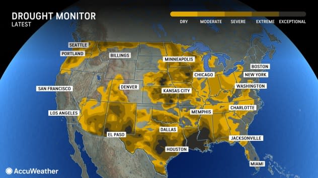
Rainfall of this magnitude could be significantly beneficial in easing drought conditions gripping the region.
Large tracts of the central U.S. have been experiencing abnormally dry conditions to the most extreme drought conditions, according to the United States Drought Monitor.
 |
Not only has this been a major problem for crops and feeding and watering livestock, but rivers in the region are also running very low. The extremely low water levels on the Mississippi River have been greatly diminishing the amount of barge commerce and have allowed salt water from the Gulf of Mexico to intrude upriver near New Orleans, threatening the drinking water supply in the region.
However, even if the rain materializes as projected, it will take many more far-reaching rainfall events to impact the Mississippi River. For example, the Red River, one of the region's major rivers in the path of potential rain, does not flow into the Mississippi River but rather the Atchafalaya River. A flood prevention project years ago re-directed the Red River's water away from the Mississippi River.
For there to be some meaningful rise on the Mississippi, heavy rain would need to fall over a broad region of the Arkansas and Missouri rivers. Any downstream surge in water could take many weeks to reach the main stem of the lower Mississippi River.
Want next-level safety, ad-free? Unlock advanced, hyperlocal severe weather alerts when you subscribe to Premium+ on the AccuWeather app. AccuWeather Alerts™ are prompted by our expert meteorologists who monitor and analyze dangerous weather risks 24/7 to keep you and your family safer.
