Bundle up, Canton! High winds and sub-freezing temperatures coming this weekend
Get ready, Canton. Cold weather is about to rumble into Northeast Ohio.
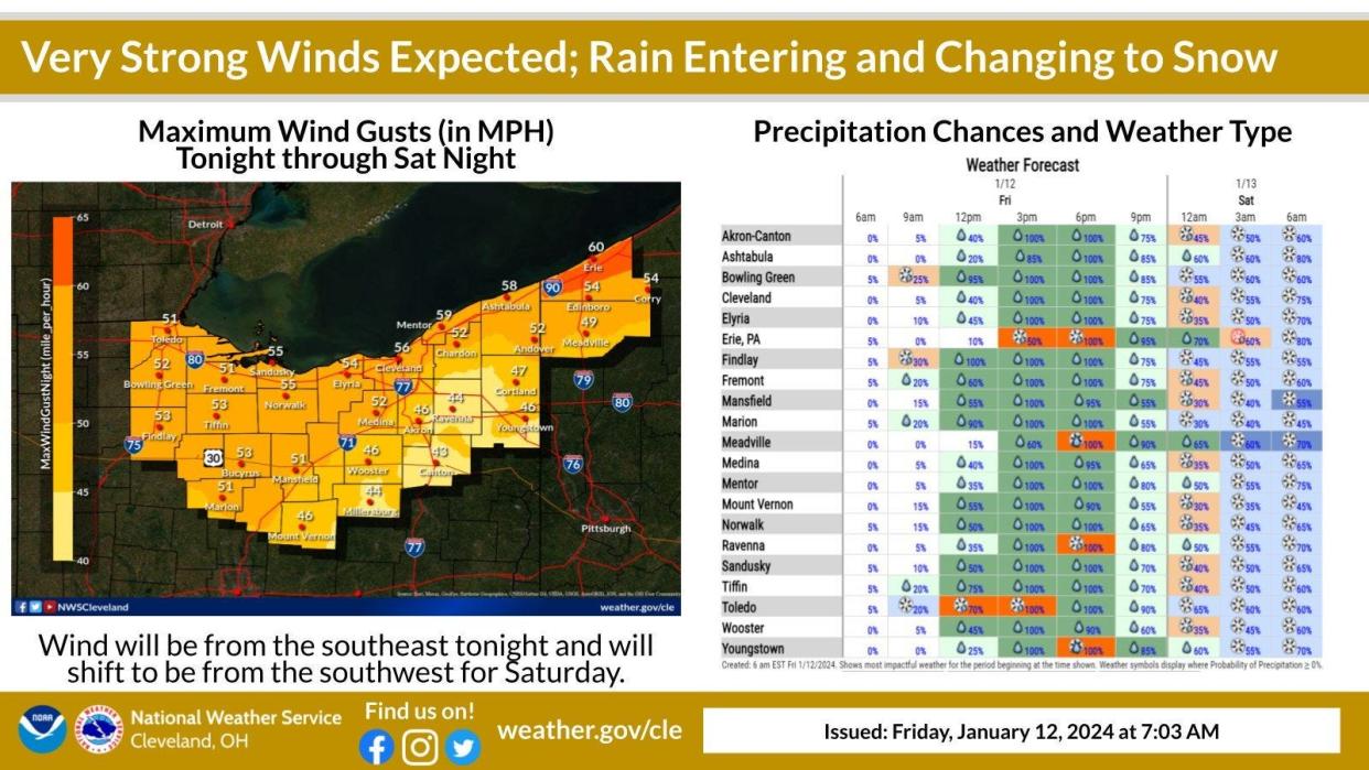
High winds and sub-freezing temperatures are expected to hit the region this weekend, according to the National Weather Service office in Cleveland.
The forecast predicts low temperatures of 15 degrees on Saturday night and 7 degrees on Sunday night.
Winds are expected to begin picking up speed today, with gusts as high as 46 mph tonight and continuing through Saturday night. A wind advisory is in place for Stark County from 4 p.m. today through 1 a.m. Sunday. Gusts of 50 to 55 mph are expected.
Milder weather is expected on Sunday and Monday, but it will be cold. Highs near 19 degrees are forecast for both days.
A low of 4 degrees is forecast for Tuesday night, and a high near 26 degrees is forecast for Thursday.
“Obviously the further we go out, the less precise our forecast, so there's more chances for things to change and shift," said meteorologist Raelene Campbell of the National Weather Service Office in Cleveland.
She said the high winds are the result of a combination of a deepening low pressure system and dropping temperatures. A cold air mass from northern Canada is expected to move into northern Ohio by the beginning of next week.
"It looks like next week we could have a couple more rounds of potential windy conditions and snow," Campbell said. "We’re staying in a really active weather pattern versus it just kind of being cloudy and not much going on for this time of year."
She advised keeping an emergency kit ready to prepare for possible power outages.
Due to the expected winter storm's high winds and snow, the Ohio Turnpike and Infrastructure Commission has issued a travel restriction across the entire toll road for all high-profile vehicles from12 a.m. to 6 p.m. Saturday.
Vehicles prohibited during the ban
High-profile vehicles are defined as those with a height exceeding 7 feet and 6 inches.
The following types of vehicles will be banned from traveling on the Ohio Turnpike until the travel restriction expires or is canceled:
All high-profile tow-behind trailers, campers, boats, and enclosed trailers. Fifth wheel trailers are excluded.
Commercial trucks towing an empty single 53-foot trailer.
All mobile homes, office trailers and livestock trailers.
All long combination vehicles that include long double-trailer combinations exceeding 90-feet in length. (Enclosed trailers only, including Conestoga-type trailers.)
All light commercial vehicle triple-trailer combinations.
Here's what the weather service says is coming our way:
Today
Rain is likely, mainly after 3 p.m. The high will be near 45 degrees. Southeast winds of 18 to 21 mph are expected with gusts as high as 36 mph. The chance of precipitation is 100%. New precipitation amounts between a 10th and a quarter of an inch are possible.
Tonight
Rain is expected before 3 a.m., followed by a chance of rain and snow until 4 a.m. The low will be around 28 degrees. It will be breezy, with a southeast wind of 20 to 24 mph becoming southwest after midnight. Winds could gust as high as 46 mph. The chance of precipitation is 90%. New snow accumulation of less than a half inch is possible.
Saturday
Snow is likely before 8 a.m. Snow showers are likely between 8 a.m and 3 p.m. Patchy blowing snow is expected before 10 a.m. It will be cloudy, with a high near 29 degrees. It will be windy, with a southwest wind 23 to 28 mph, and gusts as high as 50 mph. The chance of precipitation is 60%. New snow accumulation of less than a half inch is possible.
Saturday night
There will be a chance of snow showers, mainly after 7 p.m. Expect patchy blowing snow between 11 p.m. and 2 a.m. It will be cloudy, with a low around 15 degrees. Expect conditions to be breezy, with a southwest wind of 18 to 20 mph, and gusts as high as 38 mph. The chance of precipitation is 40%. New snow accumulation of less than a half inch is possible.
Sunday
There will be a slight chance of snow showers before 1 p.m., with patchy blowing snow between 11 a.m. and 4 p.m. It will be mostly cloudy, with a high near 19 degrees. It will be breezy, with a west wind of 18 to to 21 mph. The chance of precipitation is 20%.
Sunday night
There will be a slight chance of snow showers before 1 a.m. It will be mostly cloudy, with a low around 7 degrees. The chance of precipitation is 20%.
Monday
There is a chance of snow showers after 1 p.m. It will be mostly cloudy with a high near 19 degrees. The chance of precipitation is 30%.
Monday night
A chance of snow showers. Mostly cloudy, with a low around 11 degrees. Chance of precipitation is 40%.
Tuesday
There will be a chance of snow showers before 1 a.m. Skies will be mostly cloudy, with a high near 17 degrees. The chance of precipitation is 50%.
Tuesday night
There will be a chance of snow showers before 1 a.m. Skies will be mostly cloudy, with a low around 4 degrees. The chance of precipitation is 30%.
Wednesday
It will be partly sunny, with a high near 18 degrees.
Wednesday night
It will be mostly cloudy, with a low around 15 degrees.
Thursday
There will be a chance of snow showers. Skies will be mostly cloudy, with a high near 26 degrees. The chance of precipitation is 30%.
This article originally appeared on The Repository: Canton weather forecast calls for high winds, sub-freezing temps

